

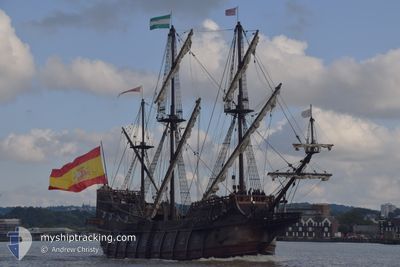
GALEON ANDALUCIA
Exhibition Ship

Current Trip
LOCTUDY FR
| Time Travelled | 12 days |
|---|---|
| Remaining Time | --- |
| Distance Travelled | 524.56 nm |
| Remaining Distance | --- |
| AVG Speed | 6.5 Noeuds |
| MAX Speed | 9.3 Noeuds |
| AVG Wind | 14.5 knots |
| MAX Wind | 18.8 knots |
| MIN Temp | 12.1°C / 53.78°F |
| MAX Temp | 17.4°C / 63.32°F |
| Tirant d eau | 3.2 m |
| Position reçue | 1 h, 30 m depuis |
Current Position
| Longitude | -5.07113° |
|---|---|
| Latitude | 47.95868° |
| Etat | Under way using engine |
| Vitesse | 7.3 Noeuds |
| Parcours | 136.7° |
| Zone | Celtic Sea |
| Station | T-AIS |
| Position reçue | 1 h, 30 m depuis |
Information
The current position of GALEON ANDALUCIA is in Celtic Sea with coordinates 47.95868° / -5.07113° as reported on 2025-06-11 20:37 by AIS to our vessel tracker app. The vessel's current speed is 7.3 Noeuds
The vessel GALEON ANDALUCIA (IMO: 9578115, MMSI: 225356000) is a Exhibition Ship that was built in 2010 ( 15 Age ). It's sailing under the flag of [ES] Spain.
In this page you can find informations about the vessels current position, last detected port calls, and current voyage information. If the vessels is not in coverage by AIS you will find the latest position.
The current position of GALEON ANDALUCIA is detected by our AIS receivers and we are not responsible for the reliability of the data. The last position was recorded while the vessel was in Coverage by the Ais receivers of our vessel tracking app.
The current draught of GALEON ANDALUCIA as reported by AIS is 3.2 meters
Weather
| Temperature | 16.9°C / 62.42°F |
|---|---|
| Wind Speed | 12 knots |
| Direction | 338° NNW |
| Pressure | 1009.6 hPa |
| Humidity | 91.1 % |
| Cloud Coverage | 100 % |


Featured Company
Last Port Calls
| Port | Arrival | Departure | Time In Port |
|---|---|---|---|
| 2025-05-21 11:51 | 2025-05-30 11:37 | 8 d | |
| 2025-05-21 09:21 | 2025-05-21 09:35 | 13 m | |
| 2025-05-09 10:46 | 2025-05-12 21:47 | 3 d | |
| 2025-05-01 11:40 | 2025-05-01 12:16 | 36 m | |
| 2025-04-24 18:16 | 2025-04-28 18:02 | 3 d | |
| 2025-04-07 13:10 | 2025-04-21 08:34 | 13 d | |
| 2025-04-06 13:12 |
Last Trips
| Origin | Departure | Destination | Arrival | Distance | |
|---|---|---|---|---|---|
| 2025-05-21 09:35 | 2025-05-21 11:51 | 10.52 nm | |||
| 2025-05-12 21:47 | 2025-05-21 09:21 | 858.30 nm | |||
| 2025-05-01 12:16 | 2025-05-09 10:46 | 462.80 nm | |||
| 2025-04-28 18:02 | 2025-05-01 11:40 | 496.42 nm | |||
| 2025-04-21 08:34 | 2025-04-24 18:16 | 451.84 nm | |||
| 2025-04-06 13:12 | 2025-04-07 13:10 | 177.83 nm |
Events
| Heure | Evenement | Détails | Position/ Destination | Info |
|---|---|---|---|---|
| 2025-06-11 20:37 | Hors de la zone couverte |
47.95868 / -5.07113
Celtic Sea
|
Vitesse: 7.3 kn Parcours: 136.7° |
|
| 2025-06-11 20:34 | Dans la zone couverte |
47.96115 / -5.07474
Celtic Sea
LOCTUDY FR
|
Vitesse: 7.5 kn Parcours: 134.1° |
|
| 2025-06-11 11:46 | Hors de la zone couverte |
48.67759 / -6.11300
Celtic Sea
LOCTUDY FR
|
Vitesse: 6.6 kn Parcours: 171° |
|
| 2025-06-11 11:46 | Changement de zone | French part of the Celtic Sea United Kingdom part of the Irish Sea and St. George's Channel |
48.67759 / -6.11300
Celtic Sea
LOCTUDY FR
|
Vitesse: 6.6 kn Parcours: 171° |
| 2025-06-11 11:45 | Dans la zone couverte |
48.67759 / -6.11300
Celtic Sea
LOCTUDY FR
|
Vitesse: 6.6 kn Parcours: 171° |
|
| 2025-06-09 11:49 | Hors de la zone couverte |
52.82535 / -4.87050
Irish Sea and St. George's Channel
LOCTUDY FR
|
Vitesse: 8.9 kn Parcours: 209.8° |
|
| 2025-06-09 11:37 | Dans la zone couverte |
52.84741 / -4.84961
Irish Sea and St. George's Channel
LOCTUDY FR
|
Vitesse: 8.2 kn Parcours: 206.7° |
|
| 2025-06-09 10:20 | Hors de la zone couverte |
52.98221 / -4.68799
Irish Sea and St. George's Channel
LOCTUDY FR
|
Vitesse: 7.4 kn Parcours: 224.9° |
|
| 2025-06-09 07:49 | Changement de destination | LOCTUDY FR CAERNAFON UK |
53.13065 / -4.31226
LOCTUDY FR
|
Vitesse: 5.6 kn Parcours: 238.8° |
| 2025-06-09 07:49 | Changement d'ETA | 2025/06/11 16:00 2025/05/31 14:00 |
53.13065 / -4.31226
LOCTUDY FR
|
Vitesse: 5.6 kn Parcours: 238.8° |