
GREAT SONG
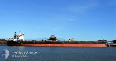
Bulk Carrier
Current Trip
| Time Travelled | 6 days |
|---|---|
| Remaining Time | 7 days |
| Distance Travelled | 1571.98 nm |
| Remaining Distance | 2032.81 nm |
| AVG Speed | 10.6 Noeuds |
| MAX Speed | 12.1 Noeuds |
| AVG Wind | 13 knots |
| MAX Wind | 22.8 knots |
| MIN Temp | 2°C / 35.6°F |
| MAX Temp | 27.5°C / 81.5°F |
| Tirant d eau | 8.6 m |
| Position reçue | 6 d depuis |
Current Position
| Longitude | 129.74538° |
|---|---|
| Latitude | 36.00306° |
| Etat | Under way using engine |
| Vitesse | 10.9 Noeuds |
| Parcours | 122.2° |
| Zone | Japan Sea |
| Station | T-AIS |
| Position reçue | 6 d depuis |
Info
Information
The current position of GREAT SONG is in Japan Sea with coordinates 36.00306° / 129.74538° as reported on 2025-02-13 04:23 by AIS to our vessel tracker app. The vessel's current speed is 10.9 Noeuds and is heading at the port of PORT HEDLAND. The estimated time of arrival as calculated by MyShipTracking vessel tracking app is 2025-02-27 00:05 LT
The vessel GREAT SONG (IMO: 9452476, MMSI: 477550900) is a Bulk Carrier that was built in 2011 ( 14 Age ). It's sailing under the flag of [HK] Hong Kong.
In this page you can find informations about the vessels current position, last detected port calls, and current voyage information. If the vessels is not in coverage by AIS you will find the latest position.
The current position of GREAT SONG is detected by our AIS receivers and we are not responsible for the reliability of the data. The last position was recorded while the vessel was in Coverage by the Ais receivers of our vessel tracking app.
The current draught of GREAT SONG as reported by AIS is 8.6 meters
Weather
| Temperature | 27.1°C / 80.78°F |
|---|---|
| Wind Speed | 16 knots |
| Direction | 52° NE |
| Pressure | 1010.9 hPa |
| Humidity | 82.2 % |
| Cloud Coverage | 99 % |
Featured Company
Most Visited Ports (Last year)
| Port | Arrivals | |
|---|---|---|
| 2 | ||
| 2 | ||
| 2 | ||
| 1 | ||
| 1 | ||
| 1 |
Last Trips
| Origin | Departure | Destination | Arrival | Distance | |
|---|---|---|---|---|---|
| 2025-02-08 14:29 | 2025-02-11 08:46 | 348.14 nm | |||
| 2025-01-16 08:44 | 2025-02-03 02:52 | 3991.09 nm | |||
| 2024-12-11 07:40 | 2025-01-13 06:10 | 5561.77 nm | |||
| 2024-11-24 15:46 | 2024-12-09 19:48 | 2840.31 nm |
Events
| Heure | Evenement | Détails | Position/ Destination | Info |
|---|---|---|---|---|
| 2025-02-13 04:28 | Etat Changé | Default Under way using engine |
35.99576 / 129.75311
KR KPO>AU PHE
|
Vitesse: 10.9 kn Parcours: 122.2° |
| 2025-02-13 04:23 | Hors de la zone couverte |
36.00306 / 129.74538
Japan Sea
KR KPO>AU PHE
|
Vitesse: 10.9 kn Parcours: 122.2° |
|
| 2025-02-13 03:05 | Tirant d'eau modifié | 8.6 8.7 |
36.09442 / 129.51076
KR KPO>AU PHE
|
Vitesse: 10.7 kn Parcours: 21.5° |
| 2025-02-13 03:05 | Changement de destination | KR KPO>AU PHE KR KWA>KR KPO |
36.09442 / 129.51076
KR KPO>AU PHE
|
Vitesse: 10.7 kn Parcours: 21.5° |
| 2025-02-13 03:05 | Changement d'ETA | 2025/02/27 04:00 2025/02/09 05:45 |
36.09442 / 129.51076
KR KPO>AU PHE
|
Vitesse: 10.7 kn Parcours: 21.5° |
| 2025-02-13 02:26 | Etat Changé | Under way using engine Default |
36.02492 / 129.43033
KR KWA>KR KPO
|
Vitesse: Parcours: 215° |
| 2025-02-13 02:26 | Démarrage | 0.95 nm, East of POHANG |
36.02492 / 129.43033
KR KWA>KR KPO
|
Vitesse: 7.7 kn Parcours: 81° |
| 2025-02-13 02:26 | Dans la zone couverte |
36.02541 / 129.43465
Japan Sea
|
Vitesse: 7.3 kn Parcours: 81.6° |
|
| 2025-02-13 02:16 | PORT DE DEPART |
|
36.02492 / 129.43033
KR KWA>KR KPO
|
Vitesse: Parcours: 215° |
| 2025-02-11 00:01 | Hors de la zone couverte |
36.02407 / 129.40692
Japan Sea
[KR] POHANG
|
Vitesse: 2.5 kn Parcours: 265.5° |