
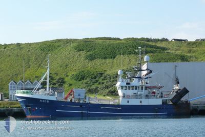
HAAFLU
Trawler
Current Trip
| Trip Time | 1 h, 10 mins |
|---|---|
| Trip Distance | 9.41 nm |
| AVG Speed | 8.5 Noeuds |
| MAX Speed | 9.8 Noeuds |
| Tirant d eau | 0 m |
| AVG Wind | 18.8 knots |
| MAX Wind | 24 knots |
| MIN Temp | 2.7°C / 36.86°F |
| MAX Temp | 3.2°C / 37.76°F |
| Position reçue | Maintenant |
Current Position
| Longitude | 5.46392° |
|---|---|
| Latitude | 59.20981° |
| Etat | Engaged in Fishing |
| Vitesse | |
| Parcours | 58° |
| Zone | North Sea |
| Station | T-AIS |
| Position reçue | Maintenant |
Info
Information
The current position of HAAFLU is in North Sea with coordinates 59.20981° / 5.46392° as reported on 2025-02-22 13:50 by AIS to our vessel tracker app. The vessel's current speed is 0 Noeuds and is currently inside the port of VESTRE BOKN.
The vessel HAAFLU (IMO: 9053725, MMSI: 257476500) is a Trawler that was built in 1992 ( 33 Age ). It's sailing under the flag of [NO] Norway.
In this page you can find informations about the vessels current position, last detected port calls, and current voyage information. If the vessels is not in coverage by AIS you will find the latest position.
The current position of HAAFLU is detected by our AIS receivers and we are not responsible for the reliability of the data. The last position was recorded while the vessel was in Coverage by the Ais receivers of our vessel tracking app.
Weather
| Temperature | 6.1°C / 42.98°F |
|---|---|
| Wind Speed | 11 knots |
| Direction | 130° SE |
| Pressure | 1007.1 hPa |
| Humidity | 98.1 % |
| Cloud Coverage | 100 % |
Featured Company
Last Port Calls
| Port | Arrival | Departure | Time In Port |
|---|---|---|---|
| 2025-02-19 16:12 | |||
| 2025-02-19 08:22 | 2025-02-19 15:02 | 6 h | |
| 2025-02-17 21:26 | 2025-02-18 08:14 | 10 h | |
| 2025-02-14 11:57 | 2025-02-14 16:11 | 4 h | |
| 2025-02-14 02:08 | 2025-02-14 10:25 | 8 h | |
| 2025-02-04 17:41 | 2025-02-09 16:50 | 4 d | |
| 2025-02-03 20:33 | 2025-02-04 14:04 | 17 h | |
| 2025-02-03 13:46 | 2025-02-03 15:45 | 1 h | |
| 2025-02-02 17:10 | 2025-02-03 10:58 | 17 h | |
| 2025-02-01 14:07 | 2025-02-02 01:58 | 11 h |
Most Visited Ports (Last year)
| Port | Arrivals | |
|---|---|---|
| 38 | ||
| 17 | ||
| 17 | ||
| 7 | ||
| 7 | ||
| 4 |
Last Trips
| Origin | Departure | Destination | Arrival | Distance | |
|---|---|---|---|---|---|
| 2025-02-19 15:02 | 2025-02-19 16:12 | 9.41 nm | |||
| 2025-02-18 08:14 | 2025-02-19 08:22 | 201.87 nm | |||
| 2025-02-14 16:11 | 2025-02-17 21:26 | 262.61 nm | |||
| 2025-02-14 10:25 | 2025-02-14 11:57 | 17.31 nm | |||
| 2025-02-09 16:50 | 2025-02-14 02:08 | 371.10 nm | |||
| 2025-02-04 14:04 | 2025-02-04 17:41 | 34.16 nm | |||
| 2025-02-03 15:45 | 2025-02-03 20:33 | 44.05 nm | |||
| 2025-02-03 10:58 | 2025-02-03 13:46 | 19.89 nm | |||
| 2025-02-02 01:58 | 2025-02-02 17:10 | 143.14 nm | |||
| 2025-01-29 10:50 | 2025-02-01 14:07 | 642.53 nm |
Events
| Heure | Evenement | Détails | Position/ Destination | Info |
|---|---|---|---|---|
| 2025-02-19 15:13 | Arret |
59.21001 / 5.46394
[NO] VESTRE BOKN
|
Vitesse: 0.3 kn Parcours: 90° |
|
| 2025-02-19 15:12 | Port d'arrivée |
|
59.21019 / 5.46415
[NO] VESTRE BOKN
|
Vitesse: 0.6 kn Parcours: 124° |
| 2025-02-19 14:02 | PORT DE DEPART |
|
59.33122 / 5.30565
CH16
|
Vitesse: 7.7 kn Parcours: 130° |
| 2025-02-19 13:56 | Démarrage |
59.33845 / 5.29852
[NO] HUSOYA
|
Vitesse: 4.6 kn Parcours: 192° |
|
| 2025-02-19 07:29 | Arret |
59.34040 / 5.29823
[NO] HUSOYA
|
Vitesse: 0.3 kn Parcours: 58° |
|
| 2025-02-19 07:22 | Port d'arrivée |
|
59.33351 / 5.30091
[NO] HUSOYA
|
Vitesse: 6.9 kn Parcours: 281° |
| 2025-02-18 18:10 | Changement de zone | Norwegian part of the North Sea Norwegian part of the Norwegian Sea |
60.99666 / 4.46594
North Sea
|
Vitesse: 8.1 kn Parcours: 178° |
| 2025-02-18 07:15 | Démarrage | 0.14 nm, South East of MJOLSTADNESET |
62.31911 / 5.67081
CH16
|
Vitesse: 8.4 kn Parcours: 241° |
| 2025-02-18 07:14 | PORT DE DEPART |
|
62.31911 / 5.67081
CH16
|
Vitesse: 0.7 kn Parcours: 166° |
| 2025-02-17 20:26 | Arret |
62.32130 / 5.67324
[NO] MJOLSTADNESET
|
Vitesse: 0.2 kn Parcours: 277° |