
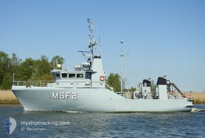
HDMS MSF2
Military ops
Current Trip
| Trip Time | 1 day |
|---|---|
| Trip Distance | 89.88 nm |
| AVG Speed | 9.2 Noeuds |
| MAX Speed | 10.6 Noeuds |
| Tirant d eau | 2.1 m |
| AVG Wind | 9.4 knots |
| MAX Wind | 15 knots |
| MIN Temp | 2.2°C / 35.96°F |
| MAX Temp | 4.1°C / 39.38°F |
| Position reçue | 5 m depuis |
Current Position
| Longitude | 11.12955° |
|---|---|
| Latitude | 55.33161° |
| Etat | Moored |
| Vitesse | |
| Parcours | 335° |
| Zone | Kattegat |
| Station | T-AIS |
| Position reçue | 5 m depuis |
Info
Information
The current position of HDMS MSF2 is in Kattegat with coordinates 55.33161° / 11.12955° as reported on 2025-03-16 02:28 by AIS to our vessel tracker app. The vessel's current speed is 0 Noeuds and is currently inside the port of KORSOR.
The vessel HDMS MSF2 (MMSI: 219000469) is a Military ops It's sailing under the flag of [DK] Denmark.
In this page you can find informations about the vessels current position, last detected port calls, and current voyage information. If the vessels is not in coverage by AIS you will find the latest position.
The current position of HDMS MSF2 is detected by our AIS receivers and we are not responsible for the reliability of the data. The last position was recorded while the vessel was in Coverage by the Ais receivers of our vessel tracking app.
The current draught of HDMS MSF2 as reported by AIS is 2.1 meters
Weather
| Temperature | 2.4°C / 36.32°F |
|---|---|
| Wind Speed | 13 knots |
| Direction | 281° W |
| Pressure | 1019.1 hPa |
| Humidity | 85.7 % |
| Cloud Coverage | 5 % |
Featured Company
Last Port Calls
| Port | Arrival | Departure | Time In Port |
|---|---|---|---|
| 2025-03-14 17:48 | |||
| 2025-03-13 12:22 | 2025-03-13 12:40 | 17 m | |
| 2025-03-12 15:19 | 2025-03-13 10:47 | 19 h | |
| 2025-03-11 14:00 | 2025-03-12 09:30 | 19 h | |
| 2025-03-10 17:07 | 2025-03-11 09:35 | 16 h | |
| 2025-03-09 14:48 | 2025-03-10 14:06 | 23 h | |
| 2025-03-03 20:29 | 2025-03-04 08:30 | 12 h | |
| 2025-02-07 07:59 | 2025-03-03 13:28 | 24 d | |
| 2025-02-04 17:48 | 2025-02-05 13:20 | 19 h | |
| 2025-02-03 13:38 | 2025-02-03 14:30 | 51 m |
Most Visited Ports (Last year)
| Port | Arrivals | |
|---|---|---|
| 17 | ||
| 16 | ||
| 2 | ||
| 1 | ||
| 1 | ||
| 1 |
Last Trips
| Origin | Departure | Destination | Arrival | Distance | |
|---|---|---|---|---|---|
| 2025-03-13 12:40 | 2025-03-14 17:48 | 89.88 nm | |||
| 2025-03-13 10:47 | 2025-03-13 12:22 | 11.11 nm | |||
| 2025-03-12 09:30 | 2025-03-12 15:19 | 31.53 nm | |||
| 2025-03-11 09:35 | 2025-03-11 14:00 | 24.34 nm | |||
| 2025-03-10 14:06 | 2025-03-10 17:07 | 19.42 nm | |||
| 2025-03-04 08:30 | 2025-03-09 14:48 | 506.32 nm | |||
| 2025-03-03 13:28 | 2025-03-03 20:29 | 57.94 nm | |||
| 2025-02-05 13:20 | 2025-02-07 07:59 | 133.28 nm | |||
| 2025-02-03 14:30 | 2025-02-04 17:48 | 133.98 nm | |||
| 2025-02-03 09:59 | 2025-02-03 13:38 | 26.53 nm |
Events
| Heure | Evenement | Détails | Position/ Destination | Info |
|---|---|---|---|---|
| 2025-03-14 16:58 | Etat Changé | Moored Under way using engine |
55.33161 / 11.12955
[DK] KORSOR
|
Vitesse: Parcours: 334° |
| 2025-03-14 16:54 | Arret |
55.33154 / 11.12922
[DK] KORSOR
|
Vitesse: 0.3 kn Parcours: 13° |
|
| 2025-03-14 16:48 | Port d'arrivée |
|
55.33306 / 11.11983
[DK] KORSOR
|
Vitesse: 8.5 kn Parcours: 76° |
| 2025-03-14 13:02 | Changement de zone | Danish part of the Kattegat Danish part of the Baltic Sea |
54.77022 / 10.88165
Kattegat
|
Vitesse: 9.9 kn Parcours: 9.4° |
| 2025-03-14 13:00 | Dans la zone couverte |
54.77022 / 10.88165
Kattegat
|
Vitesse: 9.9 kn Parcours: 9.4° |
|
| 2025-03-13 17:14 | Hors de la zone couverte |
54.67406 / 10.86321
Baltic Sea
|
Vitesse: 7 kn Parcours: 122.9° |
|
| 2025-03-13 16:46 | Etat Changé | Restricted manoeuverability Under way using engine |
54.70198 / 10.77923
NAVY PATROL
|
Vitesse: 6.5 kn Parcours: 166.1° |
| 2025-03-13 16:31 | Démarrage | 12.32 nm, South West of TARS |
54.71278 / 10.81207
NAVY PATROL
|
Vitesse: 6 kn Parcours: 253.3° |
| 2025-03-13 16:26 | Arret | 12.33 nm, South West of TARS |
54.71158 / 10.81458
NAVY PATROL
|
Vitesse: 0.3 kn Parcours: 29° |
| 2025-03-13 15:58 | Changement de zone | Danish part of the Baltic Sea Danish part of the Kattegat |
54.73778 / 10.84808
Baltic Sea
|
Vitesse: 9.8 kn Parcours: 206.3° |