
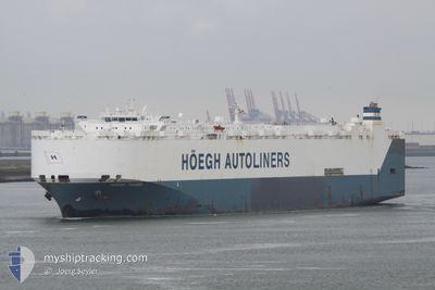
HOEGH TRADER
Vehicles Carrier
Current Trip
| Time Travelled | 37 days |
|---|---|
| Remaining Time | 1 day |
| Distance Travelled | 13177.94 nm |
| Remaining Distance | 589.52 nm |
| AVG Speed | 14.9 Noeuds |
| MAX Speed | 18.9 Noeuds |
| AVG Wind | 13.7 knots |
| MAX Wind | 33.7 knots |
| MIN Temp | 16.1°C / 60.98°F |
| MAX Temp | 29.3°C / 84.74°F |
| Tirant d eau | 9.4 m |
| Position reçue | 1 d depuis |
Current Position
| Longitude | -14.92413° |
|---|---|
| Latitude | 28.05719° |
| Etat | Under way using engine |
| Vitesse | 13.7 Noeuds |
| Parcours | 20.2° |
| Zone | North Atlantic Ocean |
| Station | T-AIS |
| Position reçue | 1 d depuis |
Info
Information
The current position of HOEGH TRADER is in North Atlantic Ocean with coordinates 28.05719° / -14.92413° as reported on 2025-12-16 18:27 by AIS to our vessel tracker app. The vessel's current speed is 13.7 Noeuds and is heading at the port of SETUBAL. The estimated time of arrival as calculated by MyShipTracking vessel tracking app is 2025-12-19 01:40 LT
The vessel HOEGH TRADER (IMO: 9171280, MMSI: 258882000) is a Vehicles Carrier that was built in 1998 ( 27 Age ). It's sailing under the flag of [NO] Norway.
In this page you can find informations about the vessels current position, last detected port calls, and current voyage information. If the vessels is not in coverage by AIS you will find the latest position.
The current position of HOEGH TRADER is detected by our AIS receivers and we are not responsible for the reliability of the data. The last position was recorded while the vessel was in Coverage by the Ais receivers of our vessel tracking app.
The current draught of HOEGH TRADER as reported by AIS is 9.4 meters
Weather
| Temperature | 17.4°C / 63.32°F |
|---|---|
| Wind Speed | 14 knots |
| Direction | 14° NNE |
| Pressure | 1023.4 hPa |
| Humidity | 64.6 % |
| Cloud Coverage | 55 % |
Featured Company
Last Port Calls
| Port | Arrival | Departure | Time In Port |
|---|---|---|---|
| 2025-11-09 13:00 | 2025-11-10 12:24 | 23 h | |
| 2025-11-05 07:40 | 2025-11-06 15:36 | 1 d | |
| 2025-10-06 05:48 | 2025-10-06 19:15 | 13 h | |
| 2025-10-04 18:34 | 2025-10-05 01:29 | 6 h | |
| 2025-10-04 07:34 | 2025-10-04 18:17 | 10 h | |
| 2025-10-01 16:39 | 2025-10-02 00:16 | 7 h |
Most Visited Ports (Last year)
| Port | Arrivals | |
|---|---|---|
| 4 | ||
| 3 | ||
| 3 | ||
| 2 | ||
| 2 | ||
| 2 |
Last Trips
| Origin | Departure | Destination | Arrival | Distance | |
|---|---|---|---|---|---|
| 2025-11-06 15:36 | 2025-11-09 13:00 | 959.79 nm | |||
| 2025-10-06 19:15 | 2025-11-05 07:40 | 10123.33 nm | |||
| 2025-10-05 01:29 | 2025-10-06 05:48 | 411.10 nm | |||
| 2025-10-04 18:17 | 2025-10-04 18:34 | 0.77 nm | |||
| 2025-10-02 00:16 | 2025-10-04 07:34 | 699.48 nm | |||
| 2025-09-26 01:00 | 2025-10-01 16:39 | 1482.31 nm |
Events
| Heure | Evenement | Détails | Position/ Destination | Info |
|---|---|---|---|---|
| 2025-12-16 18:28 | Etat Changé | Default Under way using engine |
28.05899 / -14.92338
SGSIN>PTSET
|
Vitesse: 13.7 kn Parcours: 20.2° |
| 2025-12-16 18:27 | Hors de la zone couverte |
28.05719 / -14.92413
North Atlantic Ocean
SGSIN>PTSET
|
Vitesse: 13.7 kn Parcours: 20.2° |
|
| 2025-12-16 16:52 | Etat Changé | Under way using engine Default |
27.71015 / -15.07575
SGSIN>PTSET
|
Vitesse: 14.2 kn Parcours: 21° |
| 2025-12-16 16:24 | Etat Changé | Default Under way using engine |
27.60436 / -15.12271
SGSIN>PTSET
|
Vitesse: 14.8 kn Parcours: 20° |
| 2025-12-16 16:04 | Etat Changé | Under way using engine Default |
27.52771 / -15.15639
SGSIN>PTSET
|
Vitesse: 15 kn Parcours: 22° |
| 2025-12-16 15:59 | Etat Changé | Default Under way using engine |
27.50986 / -15.16434
SGSIN>PTSET
|
Vitesse: 14.8 kn Parcours: 22.2° |
| 2025-12-16 15:01 | Etat Changé | Under way using engine Default |
27.27988 / -15.26107
SGSIN>PTSET
|
Vitesse: 15.3 kn Parcours: 19° |
| 2025-12-16 15:00 | Etat Changé | Default Under way using engine |
27.27341 / -15.26362
SGSIN>PTSET
|
Vitesse: 15.3 kn Parcours: 20.1° |
| 2025-12-16 14:35 | Detecté en mer | Spanish (Canary Islands) part of the North Atlantic Ocean |
27.17519 / -15.30406
North Atlantic Ocean
SGSIN>PTSET
|
Vitesse: 15 kn Parcours: 20.1° |
| 2025-12-16 14:34 | Etat Changé | Under way using engine Default |
27.17200 / -15.30536
SGSIN>PTSET
|
Vitesse: 15 kn Parcours: 21° |