
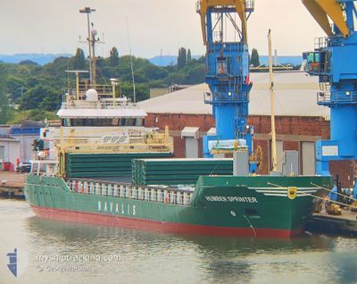
HUMBER SPRINTER
General Cargo
Current Trip
| Time Travelled | 2 days |
|---|---|
| Remaining Time | --- |
| Distance Travelled | 226.17 nm |
| Remaining Distance | --- |
| AVG Speed | 10.5 Noeuds |
| MAX Speed | 11.9 Noeuds |
| AVG Wind | 9.2 knots |
| MAX Wind | 14 knots |
| MIN Temp | -1.3°C / 29.66°F |
| MAX Temp | 1.9°C / 35.42°F |
| Tirant d eau | 4.2 m |
| Position reçue | 2 d depuis |
Current Position
| Longitude | 20.96298° |
|---|---|
| Latitude | 55.75270° |
| Etat | Under way using engine |
| Vitesse | 11.1 Noeuds |
| Parcours | 299.9° |
| Zone | Baltic Sea |
| Station | T-AIS |
| Position reçue | 2 d depuis |
Info
Information
The current position of HUMBER SPRINTER is in Baltic Sea with coordinates 55.75270° / 20.96298° as reported on 2025-02-03 16:54 by AIS to our vessel tracker app. The vessel's current speed is 11.1 Noeuds
The vessel HUMBER SPRINTER (IMO: 9467172, MMSI: 305649000) is a General Cargo that was built in 2009 ( 16 Age ). It's sailing under the flag of [AG] Antigua Barbuda.
In this page you can find informations about the vessels current position, last detected port calls, and current voyage information. If the vessels is not in coverage by AIS you will find the latest position.
The current position of HUMBER SPRINTER is detected by our AIS receivers and we are not responsible for the reliability of the data. The last position was recorded while the vessel was in Coverage by the Ais receivers of our vessel tracking app.
The current draught of HUMBER SPRINTER as reported by AIS is 4.2 meters
Weather
| Temperature | 2.7°C / 36.86°F |
|---|---|
| Wind Speed | 9 knots |
| Direction | 344° NNW |
| Pressure | 1034.1 hPa |
| Humidity | 96.7 % |
| Cloud Coverage | 100 % |
Featured Company
Last Port Calls
| Port | Arrival | Departure | Time In Port |
|---|---|---|---|
| 2025-02-03 07:48 | 2025-02-03 18:28 | 10 h | |
| 2025-01-30 08:07 | 2025-01-30 18:49 | 10 h | |
| 2025-01-27 10:10 | 2025-01-30 03:09 | 2 d | |
| 2025-01-22 15:37 | 2025-01-24 19:39 | 2 d | |
| 2025-01-18 23:44 | 2025-01-19 23:11 | 23 h | |
| 2025-01-16 12:30 | 2025-01-17 14:21 | 1 d | |
| 2025-01-08 20:05 | 2025-01-11 09:37 | 2 d | |
| 2025-01-05 06:44 | 2025-01-05 21:52 | 15 h | |
| 2024-12-29 18:07 | 2025-01-01 18:28 | 3 d | |
| 2024-12-26 10:58 | 2024-12-29 13:57 | 3 d |
Last Trips
| Origin | Departure | Destination | Arrival | Distance | |
|---|---|---|---|---|---|
| 2025-01-30 18:49 | 2025-02-03 07:48 | 964.06 nm | |||
| 2025-01-30 03:09 | 2025-01-30 08:07 | 35.17 nm | |||
| 2025-01-24 19:39 | 2025-01-27 10:10 | 511.84 nm | |||
| 2025-01-19 23:11 | 2025-01-22 15:37 | 716.57 nm | |||
| 2025-01-17 14:21 | 2025-01-18 23:44 | 319.68 nm | |||
| 2025-01-11 09:37 | 2025-01-16 12:30 | 1228.01 nm | |||
| 2025-01-05 21:52 | 2025-01-08 20:05 | 413.99 nm | |||
| 2025-01-01 18:28 | 2025-01-05 06:44 | 834.55 nm | |||
| 2024-12-29 13:57 | 2024-12-29 18:07 | 26.66 nm | |||
| 2024-12-18 16:15 | 2024-12-26 10:58 | 1287.09 nm |
Events
| Heure | Evenement | Détails | Position/ Destination | Info |
|---|---|---|---|---|
| 2025-02-05 20:59 | Arret | 4.6 nm, North of RIGA |
57.02443 / 24.08502
RIGA
|
Vitesse: 0.1 kn Parcours: 325° |
| 2025-02-05 20:45 | Démarrage | 5.03 nm, North of RIGA |
57.03155 / 24.08405
RIGA
|
Vitesse: 3.8 kn Parcours: 168° |
| 2025-02-05 11:21 | Arret | 5.18 nm, North of RIGA |
57.03402 / 24.08287
RIGA
|
Vitesse: Parcours: 145° |
| 2025-02-05 11:05 | Démarrage | 5.81 nm, North of RIGA |
57.04399 / 24.07188
RIGA
|
Vitesse: 4.4 kn Parcours: 288° |
| 2025-02-04 13:21 | Arret | 5.84 nm, North of RIGA |
57.04475 / 24.07741
RIGA
|
Vitesse: Parcours: 196° |
| 2025-02-03 17:00 | Etat Changé | Default Under way using engine |
55.76201 / 20.93557
RIGA
|
Vitesse: 11.1 kn Parcours: 299.9° |
| 2025-02-03 16:54 | Hors de la zone couverte |
55.75270 / 20.96298
Baltic Sea
|
Vitesse: 11.1 kn Parcours: 299.9° |
|
| 2025-02-03 16:28 | PORT DE DEPART |
|
55.72600 / 21.09006
RIGA
|
Vitesse: 8.4 kn Parcours: 297° |
| 2025-02-03 15:55 | Démarrage |
55.65936 / 21.15044
[LT] KLAIPEDA
|
Vitesse: 3.2 kn Parcours: 335° |
|
| 2025-02-03 15:42 | Etat Changé | Under way using engine Moored |
55.65869 / 21.15486
[LT] KLAIPEDA
|
Vitesse: Parcours: 100° |