

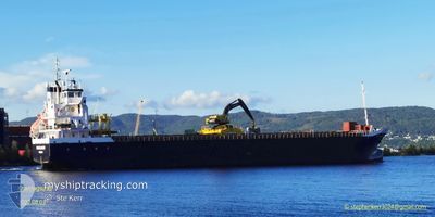
KNARRLAGSUND
General Cargo

Current Trip
| Time Travelled | 3 days |
|---|---|
| Remaining Time | 1 day |
| Distance Travelled | 808.88 nm |
| Remaining Distance | 338.28 nm |
| AVG Speed | 9.6 Noeuds |
| MAX Speed | 11.1 Noeuds |
| AVG Wind | 11.9 knots |
| MAX Wind | 21 knots |
| MIN Temp | 7.8°C / 46.04°F |
| MAX Temp | 13.4°C / 56.12°F |
| Tirant d eau | 5.4 m |
| Position reçue | 3 m depuis |
Current Position
| Longitude | 8.50677° |
|---|---|
| Latitude | 64.41495° |
| Etat | Under way using engine |
| Vitesse | 10.6 Noeuds |
| Parcours | 32° |
| Zone | Norwegian Sea |
| Station | T-AIS |
| Position reçue | 3 m depuis |
Information
The current position of KNARRLAGSUND is in Norwegian Sea with coordinates 64.41495° / 8.50677° as reported on 2025-06-11 08:22 by AIS to our vessel tracker app. The vessel's current speed is 10.6 Noeuds and is heading at the port of HARSTAD. The estimated time of arrival as calculated by MyShipTracking vessel tracking app is 2025-06-12 19:36 LT
The vessel KNARRLAGSUND (IMO: 9268849, MMSI: 257039490) is a General Cargo that was built in 2004 ( 21 Age ). It's sailing under the flag of [NO] Norway.
In this page you can find informations about the vessels current position, last detected port calls, and current voyage information. If the vessels is not in coverage by AIS you will find the latest position.
The current position of KNARRLAGSUND is detected by our AIS receivers and we are not responsible for the reliability of the data. The last position was recorded while the vessel was in Coverage by the Ais receivers of our vessel tracking app.
The current draught of KNARRLAGSUND as reported by AIS is 5.4 meters
Weather
| Temperature | 8.6°C / 47.48°F |
|---|---|
| Wind Speed | 7 knots |
| Direction | 344° NNW |
| Pressure | 1016.7 hPa |
| Humidity | 66.5 % |
| Cloud Coverage | 17 % |


Featured Company
Last Port Calls
| Port | Arrival | Departure | Time In Port |
|---|---|---|---|
| 2025-06-06 10:53 | 2025-06-07 23:49 | 1 d | |
| 2025-06-04 17:55 | 2025-06-06 00:18 | 1 d | |
| 2025-06-03 08:06 | 2025-06-04 03:05 | 18 h | |
| 2025-05-27 10:06 | 2025-05-27 23:21 | 13 h | |
| 2025-05-17 09:45 | 2025-05-19 19:13 | 2 d | |
| 2025-05-10 14:13 | 2025-05-10 16:19 | 2 h | |
| 2025-05-06 16:43 | 2025-05-08 17:41 | 2 d | |
| 2025-04-30 03:31 | 2025-05-01 00:55 | 21 h | |
| 2025-04-29 14:11 | 2025-04-29 15:02 | 51 m | |
| 2025-04-28 08:06 | 2025-04-29 12:59 | 1 d |
Last Trips
| Origin | Departure | Destination | Arrival | Distance | |
|---|---|---|---|---|---|
| 2025-06-06 00:18 | 2025-06-06 10:53 | 107.02 nm | |||
| 2025-06-04 03:05 | 2025-06-04 17:55 | 128.47 nm | |||
| 2025-05-27 23:21 | 2025-06-03 08:06 | 1286.01 nm | |||
| 2025-05-19 19:13 | 2025-05-27 10:06 | 1333.22 nm | |||
| 2025-05-10 16:19 | 2025-05-17 09:45 | 811.45 nm | |||
| 2025-05-08 17:41 | 2025-05-10 14:13 | 377.99 nm | |||
| 2025-05-01 00:55 | 2025-05-06 16:43 | 1100.19 nm | |||
| 2025-04-29 15:02 | 2025-04-30 03:31 | 134.35 nm | |||
| 2025-04-29 12:59 | 2025-04-29 14:11 | 10.01 nm | |||
| 2025-04-12 16:58 | 2025-04-28 08:06 | 2220.89 nm |
Events
| Heure | Evenement | Détails | Position/ Destination | Info |
|---|---|---|---|---|
| 2025-06-11 05:26 | Etat Changé | Under way using engine Default |
64.00337 / 7.86203
NOHRD
|
Vitesse: 10 kn Parcours: 35° |
| 2025-06-11 05:23 | Etat Changé | Default Under way using engine |
63.99497 / 7.84899
NOHRD
|
Vitesse: 10 kn Parcours: 35.6° |
| 2025-06-10 08:18 | Changement de zone | Norwegian part of the Norwegian Sea Norwegian part of the North Sea |
61.00408 / 4.43059
Norwegian Sea
NOHRD
|
Vitesse: 10.7 kn Parcours: 359° |
| 2025-06-09 14:25 | Etat Changé | Under way using engine Default |
58.00260 / 4.91670
NOHRD
|
Vitesse: 9.5 kn Parcours: 2° |
| 2025-06-09 14:21 | Etat Changé | Default Under way using engine |
57.99137 / 4.91598
NOHRD
|
Vitesse: 9.7 kn Parcours: 1.7° |
| 2025-06-09 11:00 | Etat Changé | Under way using engine Default |
57.46233 / 4.91435
NOHRD
|
Vitesse: 9.6 kn Parcours: 359° |
| 2025-06-09 10:53 | Etat Changé | Default Under way using engine |
57.44291 / 4.91469
NOHRD
|
Vitesse: 9.6 kn Parcours: 357.4° |
| 2025-06-09 10:52 | Etat Changé | Under way using engine Default |
57.44126 / 4.91479
NOHRD
|
Vitesse: 9.6 kn Parcours: 358° |
| 2025-06-09 10:25 | Etat Changé | Default Under way using engine |
57.36957 / 4.92115
NOHRD
|
Vitesse: 9.8 kn Parcours: 357.3° |
| 2025-06-09 09:24 | Etat Changé | Under way using engine Default |
57.20350 / 4.93739
NOHRD
|
Vitesse: 9.8 kn Parcours: 358° |