
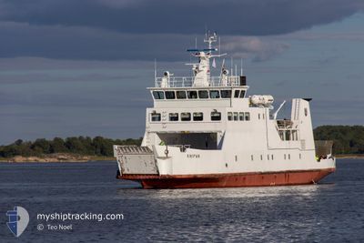
KNIPAN
Ro-Ro/Passenger Ship
Current Trip
| Trip Time | 2 h, 12 mins |
|---|---|
| Trip Distance | 23.27 nm |
| AVG Speed | 10.2 Noeuds |
| MAX Speed | 10.7 Noeuds |
| Tirant d eau | 3.8 m |
| AVG Wind | 19.5 knots |
| MAX Wind | 21.3 knots |
| MIN Temp | 0.9°C / 33.62°F |
| MAX Temp | 2.1°C / 35.78°F |
| Position reçue | Maintenant |
Current Position
| Longitude | 19.92320° |
|---|---|
| Latitude | 60.10319° |
| Etat | Under way using engine |
| Vitesse | |
| Parcours | 191° |
| Zone | Gulf of Bothnia |
| Station | T-AIS |
| Position reçue | Maintenant |
Info
Information
The current position of KNIPAN is in Gulf of Bothnia with coordinates 60.10319° / 19.92320° as reported on 2025-03-23 22:02 by AIS to our vessel tracker app. The vessel's current speed is 0 Noeuds and is currently inside the port of MARIEHAMN.
The vessel KNIPAN (IMO: 8421195, MMSI: 230992710) is a Ro-Ro/Passenger Ship that was built in 1985 ( 40 Age ). It's sailing under the flag of [FI] Finland.
In this page you can find informations about the vessels current position, last detected port calls, and current voyage information. If the vessels is not in coverage by AIS you will find the latest position.
The current position of KNIPAN is detected by our AIS receivers and we are not responsible for the reliability of the data. The last position was recorded while the vessel was in Coverage by the Ais receivers of our vessel tracking app.
The current draught of KNIPAN as reported by AIS is 3.8 meters
Weather
| Temperature | 2.7°C / 36.86°F |
|---|---|
| Wind Speed | 14 knots |
| Direction | 123° ESE |
| Pressure | 1024.1 hPa |
| Humidity | 76.9 % |
| Cloud Coverage | 91 % |
Featured Company
Last Port Calls
| Port | Arrival | Departure | Time In Port |
|---|---|---|---|
| 2025-03-17 15:25 | |||
| 2025-03-17 12:15 | 2025-03-17 13:13 | 57 m | |
| 2025-03-14 18:19 | 2025-03-15 06:50 | 12 h | |
| 2025-03-14 16:03 | 2025-03-14 16:06 | 2 m | |
| 2025-03-14 09:17 | 2025-03-14 13:37 | 4 h | |
| 2025-03-13 22:09 | 2025-03-14 06:45 | 8 h | |
| 2025-03-13 18:07 | 2025-03-13 19:42 | 1 h | |
| 2025-03-13 15:42 | 2025-03-13 16:37 | 54 m | |
| 2025-03-13 13:35 | |||
| 2025-03-12 15:45 | 2025-03-12 17:52 | 2 h |
Most Visited Ports (Last year)
| Port | Arrivals | |
|---|---|---|
| 86 | ||
| 35 | ||
| 10 | ||
| 9 |
Last Trips
| Origin | Departure | Destination | Arrival | Distance | |
|---|---|---|---|---|---|
| 2025-03-17 13:13 | 2025-03-17 15:25 | 23.27 nm | |||
| 2025-03-15 06:50 | 2025-03-17 12:15 | 48.38 nm | |||
| 2025-03-14 16:06 | 2025-03-14 18:19 | 10.11 nm | |||
| 2025-03-14 13:37 | 2025-03-14 16:03 | 10.41 nm | |||
| 2025-03-14 06:45 | 2025-03-14 09:17 | 11.51 nm | |||
| 2025-03-13 19:42 | 2025-03-13 22:09 | 10.27 nm | |||
| 2025-03-13 16:37 | 2025-03-13 18:07 | 9.66 nm | |||
| 2025-03-13 13:35 | 2025-03-13 15:42 | 12.24 nm | |||
| 2025-03-12 07:39 | 2025-03-12 15:45 | 7.38 nm | |||
| 2025-03-11 13:37 | 2025-03-11 22:13 | 6.76 nm |
Events
| Heure | Evenement | Détails | Position/ Destination | Info |
|---|---|---|---|---|
| 2025-03-17 13:34 | Arret |
60.10383 / 19.92265
[FI] MARIEHAMN
|
Vitesse: 0.2 kn Parcours: 114° |
|
| 2025-03-17 13:25 | Port d'arrivée |
|
60.08802 / 19.92646
[FI] MARIEHAMN
|
Vitesse: 9 kn Parcours: 351° |
| 2025-03-17 11:13 | PORT DE DEPART |
|
60.11347 / 20.30809
MARIEHAMN
|
Vitesse: 10.2 kn Parcours: 141° |
| 2025-03-17 11:11 | Démarrage |
60.11747 / 20.30068
[FI] LANGNAS
|
Vitesse: 6.9 kn Parcours: 127° |
|
| 2025-03-17 10:19 | Arret |
60.11742 / 20.29704
[FI] LANGNAS
|
Vitesse: 0.3 kn Parcours: 210° |
|
| 2025-03-17 10:15 | Port d'arrivée |
|
60.12057 / 20.29831
[FI] LANGNAS
|
Vitesse: 7.9 kn Parcours: 178.2° |
| 2025-03-17 07:47 | Changement de destination | MARIEHAMN OSNAS AVA |
60.29136 / 20.92699
MARIEHAMN
|
Vitesse: 9.6 kn Parcours: 269.7° |
| 2025-03-17 07:47 | Changement d'ETA | 2025/03/17 17:00 2025/07/12 15:30 |
60.29136 / 20.92699
MARIEHAMN
|
Vitesse: 9.6 kn Parcours: 269.7° |
| 2025-03-17 06:38 | Dans la zone couverte |
60.41005 / 21.12111
Gulf of Bothnia
|
Vitesse: 10.7 kn Parcours: 186.2° |
|
| 2025-03-17 01:45 | Hors de la zone couverte |
60.50331 / 21.05786
Gulf of Bothnia
|
Vitesse: Parcours: 250.5° |