
KOCIEWIE
Bulk Carrier
Current Trip
| Time Travelled | 4 days |
|---|---|
| Remaining Time | --- |
| Distance Travelled | 990.08 nm |
| Remaining Distance | --- |
| AVG Speed | 9.8 Noeuds |
| MAX Speed | 13.7 Noeuds |
| AVG Wind | 11.1 knots |
| MAX Wind | 26.3 knots |
| MIN Temp | 7.4°C / 45.32°F |
| MAX Temp | 12.4°C / 54.32°F |
| Tirant d eau | 10.4 m |
| Position reçue | 2 d depuis |
Current Position
| Longitude | -4.36212° |
|---|---|
| Latitude | 49.68800° |
| Etat | Under way using engine |
| Vitesse | 10.9 Noeuds |
| Parcours | 250° |
| Zone | English Channel |
| Station | T-AIS |
| Position reçue | 2 d depuis |
Info
Information
The current position of KOCIEWIE is in English Channel with coordinates 49.68800° / -4.36212° as reported on 2025-03-08 10:45 by AIS to our vessel tracker app. The vessel's current speed is 10.9 Noeuds and is heading at the port of MOREHEAD CITY. The estimated time of arrival as calculated by MyShipTracking vessel tracking app is 2025-03-22 04:00 LT
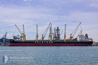
The vessel KOCIEWIE (IMO: 9423798, MMSI: 311014100) is a Bulk Carrier that was built in 2009 ( 16 Age ). It's sailing under the flag of [BS] Bahamas.
In this page you can find informations about the vessels current position, last detected port calls, and current voyage information. If the vessels is not in coverage by AIS you will find the latest position.
The current position of KOCIEWIE is detected by our AIS receivers and we are not responsible for the reliability of the data. The last position was recorded while the vessel was in Coverage by the Ais receivers of our vessel tracking app.
The current draught of KOCIEWIE as reported by AIS is 10.4 meters
Weather
| Temperature | 12°C / 53.6°F |
|---|---|
| Wind Speed | 15 knots |
| Direction | 93° E |
| Pressure | 1007.7 hPa |
| Humidity | 84.6 % |
| Cloud Coverage | 100 % |
Featured Company
Last Port Calls
| Port | Arrival | Departure | Time In Port |
|---|---|---|---|
| 2025-03-02 09:09 | 2025-03-07 03:03 | 4 d | |
| 2025-02-24 16:51 | 2025-02-25 18:41 | 1 d | |
| 2025-02-13 04:13 | 2025-02-18 23:35 | 5 d | |
| 2025-02-01 06:19 | 2025-02-08 11:03 | 7 d | |
| 2025-01-21 11:05 | 2025-01-29 12:59 | 8 d | |
| 2025-01-02 08:12 |
Last Trips
| Origin | Departure | Destination | Arrival | Distance | |
|---|---|---|---|---|---|
| 2025-02-25 19:41 | 2025-03-02 10:09 | 396.53 nm | |||
| 2025-02-18 23:35 | 2025-02-24 17:51 | 504.86 nm | |||
| 2025-02-08 12:03 | 2025-02-13 04:13 | 1052.43 nm | |||
| 2025-01-29 13:59 | 2025-02-01 07:19 | 267.95 nm | |||
| 2025-01-02 09:12 | 2025-01-21 12:05 | 2889.09 nm |
Events
| Heure | Evenement | Détails | Position/ Destination | Info |
|---|---|---|---|---|
| 2025-03-08 10:52 | Etat Changé | Default Under way using engine |
49.68128 / -4.39055
USMRH
|
Vitesse: 10.9 kn Parcours: 250° |
| 2025-03-08 10:45 | Hors de la zone couverte |
49.68800 / -4.36212
English Channel
USMRH
|
Vitesse: 10.9 kn Parcours: 250° |
|
| 2025-03-08 10:27 | Etat Changé | Under way using engine Default |
49.70600 / -4.28232
USMRH
|
Vitesse: 11.1 kn Parcours: 252° |
| 2025-03-08 09:48 | Etat Changé | Default Under way using engine |
49.74362 / -4.10527
USMRH
|
Vitesse: 11.1 kn Parcours: 251° |
| 2025-03-08 09:24 | Etat Changé | Under way using engine Default |
49.76755 / -3.99865
USMRH
|
Vitesse: 11.4 kn Parcours: 251° |
| 2025-03-08 09:24 | Etat Changé | Default Under way using engine |
49.76823 / -3.99563
USMRH
|
Vitesse: 11.4 kn Parcours: 251° |
| 2025-03-08 09:05 | Etat Changé | Under way using engine Default |
49.78805 / -3.90892
USMRH
|
Vitesse: 11.4 kn Parcours: 251° |
| 2025-03-08 09:04 | Etat Changé | Default Under way using engine |
49.78928 / -3.90337
USMRH
|
Vitesse: 11.4 kn Parcours: 250° |
| 2025-03-08 08:48 | Etat Changé | Under way using engine Default |
49.80488 / -3.83240
USMRH
|
Vitesse: 11.5 kn Parcours: 251° |
| 2025-03-08 08:36 | Etat Changé | Default Under way using engine |
49.81772 / -3.77107
USMRH
|
Vitesse: 11.7 kn Parcours: 252° |