
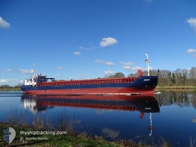
KREETE
General Cargo
Current Trip
| Trip Time | 4 days |
|---|---|
| Trip Distance | 828.08 nm |
| AVG Speed | 8.8 Noeuds |
| MAX Speed | 11.9 Noeuds |
| Tirant d eau | 3.1 m |
| AVG Wind | 10.8 knots |
| MAX Wind | 19 knots |
| MIN Temp | 8.3°C / 46.94°F |
| MAX Temp | 14.5°C / 58.1°F |
| Position reçue | 5 h, 19 m depuis |
Current Position
| Longitude | 30.15492° |
|---|---|
| Latitude | 59.89038° |
| Etat | Under way using engine |
| Vitesse | 7 Noeuds |
| Parcours | 107.7° |
| Zone | Gulf of Finland |
| Station | T-AIS |
| Position reçue | 5 h, 19 m depuis |
Information
The current position of KREETE is in Gulf of Finland with coordinates 59.89038° / 30.15492° as reported on 2025-05-30 03:45 by AIS to our vessel tracker app. The vessel's current speed is 7 Noeuds and is currently inside the port of ST PETERSBURG.
The vessel KREETE (IMO: 9279408, MMSI: 305967000) is a General Cargo that was built in 2003 ( 22 Age ). It's sailing under the flag of [AG] Antigua Barbuda.
In this page you can find informations about the vessels current position, last detected port calls, and current voyage information. If the vessels is not in coverage by AIS you will find the latest position.
The current position of KREETE is detected by our AIS receivers and we are not responsible for the reliability of the data. The last position was recorded while the vessel was in Coverage by the Ais receivers of our vessel tracking app.
The current draught of KREETE as reported by AIS is 3.1 meters
Weather
| Temperature | 15.6°C / 60.08°F |
|---|---|
| Wind Speed | 2 knots |
| Direction | 192° SSW |
| Pressure | 1007.8 hPa |
| Humidity | 90.4 % |
| Cloud Coverage | 100 % |
Featured Company
Last Port Calls
| Port | Arrival | Departure | Time In Port |
|---|---|---|---|
| 2025-05-30 06:50 | |||
| 2025-05-24 17:41 | 2025-05-26 01:08 | 1 d | |
| 2025-05-22 02:25 | 2025-05-22 20:54 | 18 h | |
| 2025-05-18 13:34 | 2025-05-20 14:43 | 2 d | |
| 2025-05-14 19:31 | 2025-05-16 19:31 | 2 d | |
| 2025-05-11 01:45 | 2025-05-11 22:06 | 20 h | |
| 2025-05-05 05:22 | 2025-05-06 22:16 | 1 d | |
| 2025-04-28 17:52 | 2025-04-30 23:58 | 2 d | |
| 2025-04-24 13:48 | 2025-04-26 00:21 | 1 d | |
| 2025-04-22 00:39 | 2025-04-22 00:42 | 3 m |
Last Trips
| Origin | Departure | Destination | Arrival | Distance | |
|---|---|---|---|---|---|
| 2025-05-26 01:08 | 2025-05-30 06:50 | 828.08 nm | |||
| 2025-05-22 20:54 | 2025-05-24 17:41 | 263.04 nm | |||
| 2025-05-20 14:43 | 2025-05-22 02:25 | 346.58 nm | |||
| 2025-05-16 19:31 | 2025-05-18 13:34 | 290.80 nm | |||
| 2025-05-11 22:06 | 2025-05-14 19:31 | 568.08 nm | |||
| 2025-05-06 22:16 | 2025-05-11 01:45 | 579.69 nm | |||
| 2025-04-30 23:58 | 2025-05-05 05:22 | 583.28 nm | |||
| 2025-04-26 00:21 | 2025-04-28 17:52 | 569.19 nm | |||
| 2025-04-22 00:42 | 2025-04-24 13:48 | 350.54 nm | |||
| 2025-04-21 11:04 | 2025-04-22 00:39 | 90.62 nm |
Events
| Heure | Evenement | Détails | Position/ Destination | Info |
|---|---|---|---|---|
| 2025-05-30 05:11 | Arret |
59.90751 / 30.23075
[RU] ST PETERSBURG
|
Vitesse: 0.1 kn Parcours: 33° |
|
| 2025-05-30 03:50 | Etat Changé | Default Under way using engine |
59.88667 / 30.17308
[RU] ST PETERSBURG
|
Vitesse: 7 kn Parcours: 107.7° |
| 2025-05-30 03:50 | Port d'arrivée |
|
59.88667 / 30.17308
[RU] ST PETERSBURG
|
Vitesse: 7 kn Parcours: 107.7° |
| 2025-05-30 03:45 | Hors de la zone couverte |
59.89038 / 30.15492
Gulf of Finland
[RU] ST PETERSBURG
|
Vitesse: 7 kn Parcours: 107.7° |
|
| 2025-05-30 03:29 | Dans la zone couverte |
59.89981 / 30.10805
Gulf of Finland
|
Vitesse: 8 kn Parcours: 116.6° |
|
| 2025-05-30 00:49 | Etat Changé | Default Under way using engine |
60.02439 / 29.39913
RU LED
|
Vitesse: 6.3 kn Parcours: 96.8° |
| 2025-05-30 00:46 | Hors de la zone couverte |
60.02469 / 29.39037
Gulf of Finland
RU LED
|
Vitesse: 6.3 kn Parcours: 96.8° |
|
| 2025-05-30 00:43 | Etat Changé | Under way using engine Default |
60.02525 / 29.38103
RU LED
|
Vitesse: 6.2 kn Parcours: 88° |
| 2025-05-30 00:42 | Etat Changé | Default Under way using engine |
60.02515 / 29.37751
RU LED
|
Vitesse: 6.3 kn Parcours: 86.4° |
| 2025-05-30 00:22 | Démarrage | 12.18 nm, North West of BRONKA |
60.01558 / 29.31698
RU LED
|
Vitesse: 4 kn Parcours: 10° |