
M
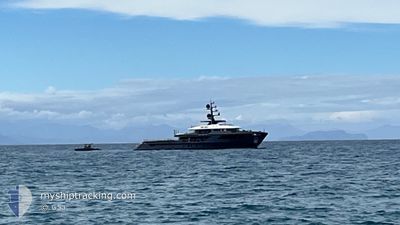
Pleasure Craft
Current Trip
| Trip Time | 5 days |
|---|---|
| Trip Distance | 152.07 nm |
| AVG Speed | 7.1 Noeuds |
| MAX Speed | 11.3 Noeuds |
| Tirant d eau | 2.9 m |
| AVG Wind | 18.1 knots |
| MAX Wind | 23 knots |
| MIN Temp | 25.1°C / 77.18°F |
| MAX Temp | 26.8°C / 80.24°F |
| Position reçue | 4 m depuis |
Current Position
| Longitude | -62.85032° |
|---|---|
| Latitude | 17.89757° |
| Etat | Moored |
| Vitesse | |
| Parcours | 244° |
| Zone | Caribbean Sea |
| Station | T-AIS |
| Position reçue | 4 m depuis |
Info
Information
The current position of M is in Caribbean Sea with coordinates 17.89757° / -62.85032° as reported on 2025-02-08 11:47 by AIS to our vessel tracker app. The vessel's current speed is 0 Noeuds and is currently inside the port of GUSTAVIA.
The vessel M (IMO: 1033078, MMSI: 319283700) is a Pleasure Craft It's sailing under the flag of [KY] Cayman Is.
In this page you can find informations about the vessels current position, last detected port calls, and current voyage information. If the vessels is not in coverage by AIS you will find the latest position.
The current position of M is detected by our AIS receivers and we are not responsible for the reliability of the data. The last position was recorded while the vessel was in Coverage by the Ais receivers of our vessel tracking app.
The current draught of M as reported by AIS is 2.9 meters
Weather
| Temperature | 25.4°C / 77.72°F |
|---|---|
| Wind Speed | 18 knots |
| Direction | 83° E |
| Pressure | 1016.7 hPa |
| Humidity | 77.3 % |
| Cloud Coverage | 15 % |
Featured Company
Last Port Calls
| Port | Arrival | Departure | Time In Port |
|---|---|---|---|
| 2025-02-07 20:35 | |||
| 2025-02-02 11:54 | 2025-02-02 12:08 | 14 m | |
| 2025-01-15 16:50 | 2025-01-26 18:12 | 11 d | |
| 2025-01-06 14:52 | 2025-01-08 14:20 | 1 d | |
| 2024-12-26 15:41 | 2024-12-29 20:02 | 3 d | |
| 2024-12-16 10:09 | 2024-12-17 08:23 | 22 h | |
| 2024-12-13 16:36 | 2024-12-13 22:30 | 5 h | |
| 2024-12-10 19:39 |
Last Trips
| Origin | Departure | Destination | Arrival | Distance | |
|---|---|---|---|---|---|
| 2025-02-02 08:08 | 2025-02-07 16:35 | 152.07 nm | |||
| 2025-01-26 14:12 | 2025-02-02 07:54 | 38.60 nm | |||
| 2025-01-08 10:20 | 2025-01-15 12:50 | 198.84 nm | |||
| 2024-12-29 16:02 | 2025-01-06 10:52 | 211.57 nm | |||
| 2024-12-17 08:23 | 2024-12-26 11:41 | 2663.34 nm | |||
| 2024-12-13 23:30 | 2024-12-16 10:09 | 729.14 nm | |||
| 2024-12-10 20:39 | 2024-12-13 17:36 | 858.81 nm |
Events
| Heure | Evenement | Détails | Position/ Destination | Info |
|---|---|---|---|---|
| 2025-02-07 21:23 | Etat Changé | Moored Under way using engine |
17.89758 / -62.85035
[BL] GUSTAVIA
|
Vitesse: Parcours: 243° |
| 2025-02-07 20:45 | Arret |
17.89807 / -62.85090
[BL] GUSTAVIA
|
Vitesse: 0.3 kn Parcours: 164° |
|
| 2025-02-07 20:35 | Port d'arrivée |
|
17.90259 / -62.85702
[BL] GUSTAVIA
|
Vitesse: 4.6 kn Parcours: 110° |
| 2025-02-07 20:23 | Démarrage | 1.08 nm, North West of GUSTAVIA |
17.91122 / -62.86853
ST BARTHS
|
Vitesse: 3.8 kn Parcours: 161° |
| 2025-02-07 19:07 | Etat Changé | Under way using engine At anchor |
17.91287 / -62.87058
ST BARTHS
|
Vitesse: 0.3 kn Parcours: 511° |
| 2025-02-07 19:07 | Etat Changé | At anchor Under way using engine |
17.91285 / -62.87059
ST BARTHS
|
Vitesse: 0.3 kn Parcours: 107° |
| 2025-02-06 21:55 | Arret | 1.19 nm, North West of GUSTAVIA |
17.91279 / -62.86970
ST BARTHS
|
Vitesse: 0.3 kn Parcours: 83° |
| 2025-02-06 20:53 | Changement de zone | Saint-Martin part of the Caribbean Sea Sint-Maarten part of the Caribbean Sea |
17.95588 / -63.00174
Caribbean Sea
ST BARTHS
|
Vitesse: 9.9 kn Parcours: 121.8° |
| 2025-02-06 20:51 | Changement de destination | ST BARTHS SXPHI |
17.95869 / -63.00657
ST BARTHS
|
Vitesse: 9.5 kn Parcours: 121.7° |
| 2025-02-06 20:51 | Changement d'ETA | 2025/02/06 18:00 2025/02/06 06:00 |
17.95869 / -63.00657
ST BARTHS
|
Vitesse: 9.5 kn Parcours: 121.7° |