
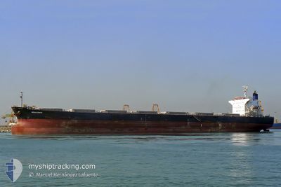
MEGALOHARI
Bulk Carrier
Current Trip
| Trip Time | 26 days |
|---|---|
| Trip Distance | 4595.82 nm |
| AVG Speed | 9.1 Noeuds |
| MAX Speed | 13 Noeuds |
| Tirant d eau | 14.2 m |
| AVG Wind | 7.9 knots |
| MAX Wind | 27 knots |
| MIN Temp | 16.2°C / 61.16°F |
| MAX Temp | 29.6°C / 85.28°F |
| Position reçue | 9 d depuis |
Current Position
| Longitude | 103.48109° |
|---|---|
| Latitude | 1.22340° |
| Etat | Under way using engine |
| Vitesse | 9.3 Noeuds |
| Parcours | 281.4° |
| Zone | Singapore Strait |
| Station | T-AIS |
| Position reçue | 9 d depuis |
Info
Information
The current position of MEGALOHARI is in Singapore Strait with coordinates 1.22340° / 103.48109° as reported on 2025-03-01 05:46 by AIS to our vessel tracker app. The vessel's current speed is 9.3 Noeuds and is currently inside the port of KAKINADA.
The vessel MEGALOHARI (IMO: 9296066, MMSI: 209485000) is a Bulk Carrier that was built in 2004 ( 21 Age ). It's sailing under the flag of [CY] Cyprus.
In this page you can find informations about the vessels current position, last detected port calls, and current voyage information. If the vessels is not in coverage by AIS you will find the latest position.
The current position of MEGALOHARI is detected by our AIS receivers and we are not responsible for the reliability of the data. The last position was recorded while the vessel was in Coverage by the Ais receivers of our vessel tracking app.
The current draught of MEGALOHARI as reported by AIS is 14.2 meters
Weather
| Temperature | 23°C / 73.4°F |
|---|---|
| Wind Speed | 5 knots |
| Direction | 39° NE |
| Pressure | 1013.4 hPa |
| Humidity | 78.2 % |
| Cloud Coverage | 31 % |
Featured Company
Events
| Heure | Evenement | Détails | Position/ Destination | Info |
|---|---|---|---|---|
| 2025-03-08 23:42 | Arret |
16.96568 / 82.28204
[IN] KAKINADA
|
Vitesse: 0.1 kn Parcours: 11° |
|
| 2025-03-08 22:37 | Port d'arrivée |
|
16.99170 / 82.32278
[IN] KAKINADA
|
Vitesse: 7.6 kn Parcours: 230° |
| 2025-03-08 21:26 | Démarrage | 8.66 nm, North East of KAKINADA |
17.05029 / 82.41959
IN KAK
|
Vitesse: 3.7 kn Parcours: 208° |
| 2025-03-08 00:46 | Arret | 9.1 nm, North East of KAKINADA |
17.05538 / 82.42525
IN KAK
|
Vitesse: 0.3 kn Parcours: 346° |
| 2025-03-01 05:54 | Etat Changé | Default Under way using engine |
1.22792 / 103.46128
IN KAK
|
Vitesse: 9.3 kn Parcours: 281.4° |
| 2025-03-01 05:46 | Hors de la zone couverte |
1.22340 / 103.48109
Singapore Strait
IN KAK
|
Vitesse: 9.3 kn Parcours: 281.4° |
|
| 2025-03-01 05:05 | Changement de zone | Malaysian part of the Singapore Strait Indonesian part of the Singapore Strait |
1.19520 / 103.58563
Singapore Strait
IN KAK
|
Vitesse: 9.4 kn Parcours: 286.1° |
| 2025-03-01 04:31 | Changement de zone | Indonesian part of the Singapore Strait Singaporean part of the Singapore Strait |
1.17763 / 103.67125
Singapore Strait
IN KAK
|
Vitesse: 9.2 kn Parcours: 283.3° |
| 2025-03-01 02:04 | Démarrage | 2.03 nm, South West of TANAH MERAH |
1.28503 / 103.99753
IN KAK
|
Vitesse: 3.1 kn Parcours: 106° |
| 2025-03-01 01:59 | Etat Changé | Under way using engine Default |
1.28600 / 103.99575
IN KAK
|
Vitesse: 0.3 kn Parcours: 86° |