
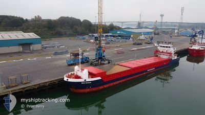
MIA MARIA
General Cargo
Current Trip
GBLER
| Time Travelled | 4 h, 32 mins |
|---|---|
| Remaining Time | --- |
| Distance Travelled | 41.48 nm |
| Remaining Distance | --- |
| AVG Speed | 9.8 Noeuds |
| MAX Speed | 10.2 Noeuds |
| AVG Wind | 11.8 knots |
| MAX Wind | 14 knots |
| MIN Temp | 4.5°C / 40.1°F |
| MAX Temp | 6.7°C / 44.06°F |
| Tirant d eau | 4.3 m |
| Position reçue | 2 d depuis |
Current Position
| Longitude | 1.81956° |
|---|---|
| Latitude | 54.33940° |
| Etat | Under way using engine |
| Vitesse | 9.9 Noeuds |
| Parcours | 328.4° |
| Zone | North Sea |
| Station | T-AIS |
| Position reçue | 2 d depuis |
Info
Information
The current position of MIA MARIA is in North Sea with coordinates 54.33940° / 1.81956° as reported on 2025-02-08 07:34 by AIS to our vessel tracker app. The vessel's current speed is 9.9 Noeuds
The vessel MIA MARIA (IMO: 9518218, MMSI: 210172000) is a General Cargo that was built in 2012 ( 13 Age ). It's sailing under the flag of [CY] Cyprus.
In this page you can find informations about the vessels current position, last detected port calls, and current voyage information. If the vessels is not in coverage by AIS you will find the latest position.
The current position of MIA MARIA is detected by our AIS receivers and we are not responsible for the reliability of the data. The last position was recorded while the vessel was in Coverage by the Ais receivers of our vessel tracking app.
The current draught of MIA MARIA as reported by AIS is 4.3 meters
Weather
| Temperature | 6.7°C / 44.06°F |
|---|---|
| Wind Speed | 14 knots |
| Direction | 90° E |
| Pressure | 1040.7 hPa |
| Humidity | 66.8 % |
| Cloud Coverage | 5 % |
Featured Company
Last Port Calls
| Port | Arrival | Departure | Time In Port |
|---|---|---|---|
| 2025-02-09 23:19 | 2025-02-10 15:39 | 16 h | |
| 2025-02-06 00:27 | 2025-02-07 05:18 | 1 d | |
| 2025-01-14 18:06 | 2025-01-21 14:10 | 6 d | |
| 2025-01-13 02:59 | 2025-01-13 17:48 | 14 h | |
| 2025-01-08 17:44 | 2025-01-09 15:02 | 21 h | |
| 2024-12-16 04:16 | 2024-12-17 17:17 | 1 d | |
| 2024-12-11 17:25 | 2024-12-12 20:17 | 1 d | |
| 2024-12-09 00:41 | 2024-12-10 16:33 | 1 d | |
| 2024-12-02 17:16 |
Last Trips
| Origin | Departure | Destination | Arrival | Distance | |
|---|---|---|---|---|---|
| 2025-02-07 06:18 | 2025-02-09 23:19 | 596.04 nm | |||
| 2025-01-21 15:10 | 2025-02-06 01:27 | 2136.99 nm | |||
| 2025-01-13 18:48 | 2025-01-14 19:06 | 149.33 nm | |||
| 2025-01-09 16:02 | 2025-01-13 03:59 | 763.70 nm | |||
| 2024-12-17 17:17 | 2025-01-08 18:44 | 1109.97 nm | |||
| 2024-12-12 20:17 | 2024-12-16 04:16 | 707.55 nm | |||
| 2024-12-10 16:33 | 2024-12-11 17:25 | 245.68 nm | |||
| 2024-12-02 18:16 | 2024-12-09 00:41 | 1350.23 nm |
Events
| Heure | Evenement | Détails | Position/ Destination | Info |
|---|---|---|---|---|
| 2025-02-10 15:39 | PORT DE DEPART |
|
60.15514 / -1.13423
GBLER
|
Vitesse: 8.2 kn Parcours: 133° |
| 2025-02-10 15:31 | Démarrage |
60.16943 / -1.15376
[GB] LERWICK
|
Vitesse: 8.4 kn Parcours: 193° |
|
| 2025-02-09 23:31 | Arret |
60.17838 / -1.15489
[GB] LERWICK
|
Vitesse: 0.1 kn Parcours: 181° |
|
| 2025-02-09 23:19 | Port d'arrivée |
|
60.18038 / -1.14998
[GB] LERWICK
|
Vitesse: 2.5 kn Parcours: 214° |
| 2025-02-08 07:47 | Etat Changé | Default Under way using engine |
54.37112 / 1.78982
GBLER
|
Vitesse: 9.9 kn Parcours: 328.4° |
| 2025-02-08 07:34 | Hors de la zone couverte |
54.33940 / 1.81956
North Sea
GBLER
|
Vitesse: 9.9 kn Parcours: 328.4° |
|
| 2025-02-08 05:12 | Etat Changé | Under way using engine Default |
53.99918 / 2.14690
GBLER
|
Vitesse: 9.3 kn Parcours: 333° |
| 2025-02-08 05:05 | Etat Changé | Default Under way using engine |
53.98231 / 2.16204
GBLER
|
Vitesse: 9.5 kn Parcours: 335.9° |
| 2025-02-08 04:27 | Changement d'ETA | 2025/02/09 18:00 2025/02/09 16:00 |
53.89320 / 2.24819
GBLER
|
Vitesse: 9.5 kn Parcours: 333.4° |
| 2025-02-08 03:41 | Changement de zone | United Kingdom part of the North Sea Dutch part of the North Sea |
53.79219 / 2.35075
North Sea
GBLER
|
Vitesse: 9.2 kn Parcours: 332.8° |