

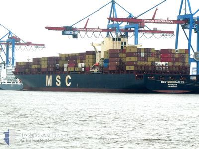
MSC MICHIGAN VII
Container Ship
Current Trip
| Time Travelled | 5 h, 44 mins |
|---|---|
| Remaining Time | --- |
| Distance Travelled | 31.16 nm |
| Remaining Distance | --- |
| AVG Speed | 12.1 Noeuds |
| MAX Speed | 15.1 Noeuds |
| AVG Wind | 16.5 knots |
| MAX Wind | 17.1 knots |
| MIN Temp | 28.6°C / 83.48°F |
| MAX Temp | 29.7°C / 85.46°F |
| Tirant d eau | 12.5 m |
| Position reçue | 5 d depuis |
Current Position
| Longitude | 76.69031° |
|---|---|
| Latitude | 8.42831° |
| Etat | Under way using engine |
| Vitesse | 17.4 Noeuds |
| Parcours | 299.3° |
| Zone | Laccadive Sea |
| Station | T-AIS |
| Position reçue | 5 d depuis |
Information
The current position of MSC MICHIGAN VII is in Laccadive Sea with coordinates 8.42831° / 76.69031° as reported on 2025-06-06 18:04 by AIS to our vessel tracker app. The vessel's current speed is 17.4 Noeuds
The vessel MSC MICHIGAN VII (IMO: 9196864, MMSI: 636021994) is a Container Ship that was built in 2000 ( 25 Age ). It's sailing under the flag of [LR] Liberia.
In this page you can find informations about the vessels current position, last detected port calls, and current voyage information. If the vessels is not in coverage by AIS you will find the latest position.
The current position of MSC MICHIGAN VII is detected by our AIS receivers and we are not responsible for the reliability of the data. The last position was recorded while the vessel was in Coverage by the Ais receivers of our vessel tracking app.
The current draught of MSC MICHIGAN VII as reported by AIS is 12.5 meters
Weather
| Temperature | 28.9°C / 84.02°F |
|---|---|
| Wind Speed | 17 knots |
| Direction | 270° W |
| Pressure | 1003.5 hPa |
| Humidity | 83.6 % |
| Cloud Coverage | 41 % |
Featured Company
Last Port Calls
| Port | Arrival | Departure | Time In Port |
|---|---|---|---|
| 2025-06-11 17:17 | 2025-06-12 07:07 | 13 h | |
| 2025-06-08 19:25 | 2025-06-09 23:48 | 1 d | |
| 2025-06-02 11:34 | 2025-06-02 18:19 | 6 h | |
| 2025-05-22 20:15 | 2025-05-23 20:15 | 23 h | |
| 2025-05-21 12:12 | 2025-05-22 10:17 | 22 h | |
| 2025-04-23 13:16 | 2025-04-25 11:06 | 1 d | |
| 2025-04-21 17:44 | 2025-04-22 14:40 | 20 h | |
| 2025-04-16 03:16 | 2025-04-17 03:57 | 1 d | |
| 2025-04-13 07:23 | 2025-04-15 13:30 | 2 d | |
| 2025-04-10 17:22 | 2025-04-12 02:22 | 1 d |
Most Visited Ports (Last year)
| Port | Arrivals | |
|---|---|---|
| 4 | ||
| 3 | ||
| 3 | ||
| 3 | ||
| 3 | ||
| 3 |
Last Trips
| Origin | Departure | Destination | Arrival | Distance | |
|---|---|---|---|---|---|
| 2025-06-09 23:48 | 2025-06-11 17:17 | 532.90 nm | |||
| 2025-06-02 18:19 | 2025-06-08 19:25 | 1003.12 nm | |||
| 2025-05-23 20:15 | 2025-06-02 11:34 | 2498.27 nm | |||
| 2025-05-22 10:17 | 2025-05-22 20:15 | 4.28 nm | |||
| 2025-04-25 11:06 | 2025-05-21 12:12 | 8825.32 nm | |||
| 2025-04-22 14:40 | 2025-04-23 13:16 | 263.51 nm | |||
| 2025-04-17 03:57 | 2025-04-21 17:44 | 608.18 nm | |||
| 2025-04-15 13:30 | 2025-04-16 03:16 | 139.53 nm | |||
| 2025-04-12 02:22 | 2025-04-13 07:23 | 324.23 nm | |||
| 2025-04-10 05:06 | 2025-04-10 17:22 | 117.31 nm |
Events
| Heure | Evenement | Détails | Position/ Destination | Info |
|---|---|---|---|---|
| 2025-06-12 02:07 | PORT DE DEPART |
|
24.78553 / 67.28012
INNSA
|
Vitesse: 6.8 kn Parcours: 299° |
| 2025-06-12 01:43 | Démarrage |
24.76214 / 67.32307
[PK] PORT QASIM
|
Vitesse: 4.5 kn Parcours: 283° |
|
| 2025-06-11 12:31 | Arret |
24.76420 / 67.32916
[PK] PORT QASIM
|
Vitesse: 0.3 kn Parcours: 46° |
|
| 2025-06-11 12:17 | Port d'arrivée |
|
24.76263 / 67.32920
[PK] PORT QASIM
|
Vitesse: 4.3 kn Parcours: 80° |
| 2025-06-09 18:18 | PORT DE DEPART |
|
18.94478 / 72.93052
INNSA
|
Vitesse: 7 kn Parcours: 224° |
| 2025-06-09 18:07 | Démarrage |
18.96039 / 72.94662
[IN] NHAVA SHEVA
|
Vitesse: 5.3 kn Parcours: 214° |
|
| 2025-06-08 14:05 | Arret |
18.96488 / 72.95101
[IN] NHAVA SHEVA
|
Vitesse: 0.1 kn Parcours: 203° |
|
| 2025-06-08 13:55 | Port d'arrivée |
|
18.96506 / 72.95010
[IN] NHAVA SHEVA
|
Vitesse: 0.9 kn Parcours: 198° |
| 2025-06-06 18:09 | Etat Changé | Default Under way using engine |
8.43884 / 76.67094
INNSA
|
Vitesse: 17.4 kn Parcours: 299.3° |
| 2025-06-06 18:04 | Hors de la zone couverte |
8.42831 / 76.69031
Laccadive Sea
INNSA
|
Vitesse: 17.4 kn Parcours: 299.3° |