
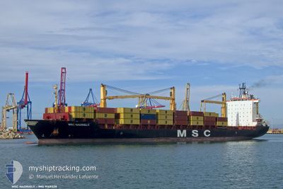
MSC NADRIELY
Container Ship
Current Trip
| Trip Time | 1 day |
|---|---|
| Trip Distance | 471.58 nm |
| AVG Speed | 11 Noeuds |
| MAX Speed | 15.1 Noeuds |
| Tirant d eau | 8.3 m |
| AVG Wind | 12.1 knots |
| MAX Wind | 17 knots |
| MIN Temp | 23.2°C / 73.76°F |
| MAX Temp | 25°C / 77°F |
| Position reçue | 1 d depuis |
Current Position
| Longitude | -97.48072° |
|---|---|
| Latitude | 22.47637° |
| Etat | Under way using engine |
| Vitesse | 10.9 Noeuds |
| Parcours | 93.9° |
| Zone | Gulf of Mexico |
| Station | T-AIS |
| Position reçue | 1 d depuis |
Info
Information
The current position of MSC NADRIELY is in Gulf of Mexico with coordinates 22.47637° / -97.48072° as reported on 2025-02-09 02:39 by AIS to our vessel tracker app. The vessel's current speed is 10.9 Noeuds and is currently inside the port of PROGRESO.
The vessel MSC NADRIELY (IMO: 9149328, MMSI: 636016805) is a Container Ship that was built in 1998 ( 27 Age ). It's sailing under the flag of [LR] Liberia.
In this page you can find informations about the vessels current position, last detected port calls, and current voyage information. If the vessels is not in coverage by AIS you will find the latest position.
The current position of MSC NADRIELY is detected by our AIS receivers and we are not responsible for the reliability of the data. The last position was recorded while the vessel was in Coverage by the Ais receivers of our vessel tracking app.
The current draught of MSC NADRIELY as reported by AIS is 8.3 meters
Weather
| Temperature | 25.6°C / 78.08°F |
|---|---|
| Wind Speed | 13 knots |
| Direction | 52° NE |
| Pressure | 1014.9 hPa |
| Humidity | 74.7 % |
| Cloud Coverage | 99 % |
Featured Company
Last Port Calls
| Port | Arrival | Departure | Time In Port |
|---|---|---|---|
| 2025-02-10 22:01 | |||
| 2025-02-08 14:10 | 2025-02-09 00:44 | 10 h | |
| 2025-02-04 13:07 | 2025-02-05 16:11 | 1 d | |
| 2025-01-28 17:41 | 2025-01-29 20:30 | 1 d | |
| 2025-01-22 14:16 | 2025-01-24 01:15 | 1 d | |
| 2025-01-16 05:11 | 2025-01-16 20:27 | 15 h | |
| 2025-01-05 18:51 | 2025-01-06 19:43 | 1 d | |
| 2025-01-02 13:38 | 2025-01-03 06:31 | 16 h | |
| 2024-12-30 12:58 | 2024-12-30 23:30 | 10 h | |
| 2024-12-27 12:56 | 2024-12-28 02:24 | 13 h |
Last Trips
| Origin | Departure | Destination | Arrival | Distance | |
|---|---|---|---|---|---|
| 2025-02-08 18:44 | 2025-02-10 16:01 | 471.58 nm | |||
| 2025-02-05 11:11 | 2025-02-08 08:10 | 1154.32 nm | |||
| 2025-01-29 17:00 | 2025-02-04 08:07 | 1847.53 nm | |||
| 2025-01-23 20:15 | 2025-01-28 14:11 | 742.63 nm | |||
| 2025-01-16 15:27 | 2025-01-22 09:16 | 1561.22 nm | |||
| 2025-01-06 14:43 | 2025-01-16 00:11 | 1219.59 nm | |||
| 2025-01-03 00:31 | 2025-01-05 13:51 | 719.50 nm | |||
| 2024-12-30 17:30 | 2025-01-02 07:38 | 467.31 nm | |||
| 2024-12-27 20:24 | 2024-12-30 06:58 | 251.01 nm | |||
| 2024-12-22 18:11 | 2024-12-27 06:56 | 1133.15 nm |
Events
| Heure | Evenement | Détails | Position/ Destination | Info |
|---|---|---|---|---|
| 2025-02-10 22:48 | Arret |
21.34475 / -89.67889
[MX] PROGRESO
|
Vitesse: 0.1 kn Parcours: 269° |
|
| 2025-02-10 22:01 | Port d'arrivée |
|
21.35137 / -89.68840
[MX] PROGRESO
|
Vitesse: 12.3 kn Parcours: 180° |
| 2025-02-09 02:44 | Etat Changé | Default Under way using engine |
22.47463 / -97.46349
MX PGO
|
Vitesse: 10.9 kn Parcours: 93.9° |
| 2025-02-09 02:39 | Hors de la zone couverte |
22.47637 / -97.48072
Gulf of Mexico
MX PGO
|
Vitesse: 10.9 kn Parcours: 93.9° |
|
| 2025-02-09 01:26 | Changement d'ETA | 2025/02/10 19:00 2025/02/11 19:00 |
22.48064 / -97.72009
MX PGO
|
Vitesse: 11.1 kn Parcours: 91.9° |
| 2025-02-09 00:44 | PORT DE DEPART |
|
22.48747 / -97.85686
MX PGO
|
Vitesse: 7.1 kn Parcours: 91° |
| 2025-02-09 00:25 | Démarrage |
22.47725 / -97.88601
[MX] ALTAMIRA
|
Vitesse: 3.7 kn Parcours: 347° |
|
| 2025-02-09 00:19 | Tirant d'eau modifié | 8.3 8.5 |
22.47555 / -97.88476
[MX] ALTAMIRA
|
Vitesse: 0.1 kn Parcours: 347° |
| 2025-02-09 00:18 | Etat Changé | Under way using engine Moored |
22.47557 / -97.88476
[MX] ALTAMIRA
|
Vitesse: 0.1 kn Parcours: 346° |
| 2025-02-08 20:12 | Etat Changé | Moored Under way using engine |
22.47561 / -97.88476
[MX] ALTAMIRA
|
Vitesse: Parcours: 347° |