

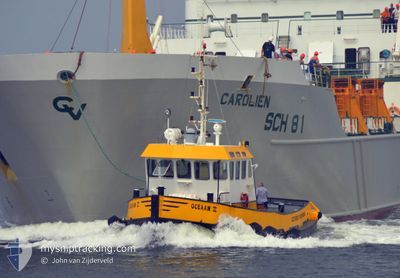
OCEAAN 2
Tug

Current Trip
| Trip Time | 2 h, 14 mins |
|---|---|
| Trip Distance | 6.64 nm |
| AVG Speed | 8 Noeuds |
| MAX Speed | 10.6 Noeuds |
| Tirant d eau | 2.2 m |
| AVG Wind | 7.1 knots |
| MAX Wind | 8.6 knots |
| MIN Temp | 14.7°C / 58.46°F |
| MAX Temp | 20.8°C / 69.44°F |
| Position reçue | 1 m depuis |
Current Position
| Longitude | 4.26398° |
|---|---|
| Latitude | 52.09939° |
| Etat | Under way using engine |
| Vitesse | |
| Parcours | --- |
| Zone | North Sea |
| Station | T-AIS |
| Position reçue | 1 m depuis |
Information
The current position of OCEAAN 2 is in North Sea with coordinates 52.09939° / 4.26398° as reported on 2025-06-07 22:43 by AIS to our vessel tracker app. The vessel's current speed is 0 Noeuds and is currently inside the port of SCHEVENINGEN.
The vessel OCEAAN 2 (IMO: 9110406, MMSI: 246003000) is a Tug It's sailing under the flag of [NL] Netherlands.
In this page you can find informations about the vessels current position, last detected port calls, and current voyage information. If the vessels is not in coverage by AIS you will find the latest position.
The current position of OCEAAN 2 is detected by our AIS receivers and we are not responsible for the reliability of the data. The last position was recorded while the vessel was in Coverage by the Ais receivers of our vessel tracking app.
The current draught of OCEAAN 2 as reported by AIS is 2.2 meters
Weather
| Temperature | 13.5°C / 56.3°F |
|---|---|
| Wind Speed | 13 knots |
| Direction | 218° SW |
| Pressure | 1003.7 hPa |
| Humidity | 92.4 % |
| Cloud Coverage | 98 % |


Featured Company
Last Port Calls
| Port | Arrival | Departure | Time In Port |
|---|---|---|---|
| 2025-05-31 15:44 | |||
| 2025-05-31 12:06 | 2025-05-31 13:30 | 1 h | |
| 2025-05-31 09:48 |
Most Visited Ports (Last year)
| Port | Arrivals | |
|---|---|---|
| 14 |
Last Trips
| Origin | Departure | Destination | Arrival | Distance | |
|---|---|---|---|---|---|
| 2025-05-31 13:30 | 2025-05-31 15:44 | 6.64 nm | |||
| 2025-05-31 09:48 | 2025-05-31 12:06 | 5.02 nm |
Events
| Heure | Evenement | Détails | Position/ Destination | Info |
|---|---|---|---|---|
| 2025-05-31 13:50 | Arret |
52.09803 / 4.26358
[NL] SCHEVENINGEN
|
Vitesse: 0.3 kn Parcours: 511° |
|
| 2025-05-31 13:44 | Port d'arrivée |
|
52.10406 / 4.25425
[NL] SCHEVENINGEN
|
Vitesse: 9 kn Parcours: 156.6° |
| 2025-05-31 13:28 | Démarrage | 2.98 nm, North West of SCHEVENINGEN |
52.13332 / 4.20635
SCHEVENINGEN
|
Vitesse: 6.8 kn Parcours: 139.8° |
| 2025-05-31 13:19 | Arret | 3.09 nm, North West of SCHEVENINGEN |
52.13498 / 4.20490
SCHEVENINGEN
|
Vitesse: 0.2 kn Parcours: 511° |
| 2025-05-31 13:13 | Démarrage | 3.13 nm, North West of SCHEVENINGEN |
52.13622 / 4.20554
SCHEVENINGEN
|
Vitesse: 3.5 kn Parcours: 116.2° |
| 2025-05-31 11:47 | Arret | 2.67 nm, North West of SCHEVENINGEN |
52.13903 / 4.23516
SCHEVENINGEN
|
Vitesse: 0.2 kn Parcours: 511° |
| 2025-05-31 11:30 | PORT DE DEPART |
|
52.10547 / 4.25291
SCHEVENINGEN
|
Vitesse: 9.5 kn Parcours: 320.8° |
| 2025-05-31 11:27 | Démarrage |
52.09912 / 4.26092
[NL] SCHEVENINGEN
|
Vitesse: 7.5 kn Parcours: 305.4° |
|
| 2025-05-31 10:11 | Arret |
52.09808 / 4.26350
[NL] SCHEVENINGEN
|
Vitesse: 0.2 kn Parcours: 511° |
|
| 2025-05-31 10:06 | Port d'arrivée |
|
52.10378 / 4.25396
[NL] SCHEVENINGEN
|
Vitesse: 8.4 kn Parcours: 146.6° |