
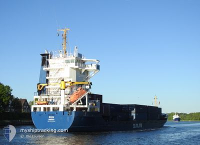
ODIN
General Cargo
Current Trip
| Trip Time | 12 h, 49 mins |
|---|---|
| Trip Distance | 140.12 nm |
| AVG Speed | 11 Noeuds |
| MAX Speed | 14 Noeuds |
| Tirant d eau | 4.9 m |
| AVG Wind | 15.9 knots |
| MAX Wind | 21.1 knots |
| MIN Temp | 2.9°C / 37.22°F |
| MAX Temp | 4.7°C / 40.46°F |
| Position reçue | Maintenant |
Current Position
| Longitude | 4.76402° |
|---|---|
| Latitude | 52.42518° |
| Etat | Under way using engine |
| Vitesse | |
| Parcours | 72° |
| Zone | North Sea |
| Station | T-AIS |
| Position reçue | Maintenant |
Info
Information
The current position of ODIN is in North Sea with coordinates 52.42518° / 4.76402° as reported on 2025-02-11 11:45 by AIS to our vessel tracker app. The vessel's current speed is 0 Noeuds and is currently inside the port of AMSTERDAM.
The vessel ODIN (IMO: 9101144, MMSI: 255805955) is a General Cargo that was built in 1994 ( 31 Age ). It's sailing under the flag of [PT] Portugal.
In this page you can find informations about the vessels current position, last detected port calls, and current voyage information. If the vessels is not in coverage by AIS you will find the latest position.
The current position of ODIN is detected by our AIS receivers and we are not responsible for the reliability of the data. The last position was recorded while the vessel was in Coverage by the Ais receivers of our vessel tracking app.
The current draught of ODIN as reported by AIS is 4.9 meters
Weather
| Temperature | 2.8°C / 37.04°F |
|---|---|
| Wind Speed | 8 knots |
| Direction | 120° ESE |
| Pressure | 1017.2 hPa |
| Humidity | 97.8 % |
| Cloud Coverage | 100 % |
Featured Company
Last Port Calls
| Port | Arrival | Departure | Time In Port |
|---|---|---|---|
| 2025-02-11 09:45 | |||
| 2025-02-09 09:09 | 2025-02-10 20:56 | 1 d | |
| 2025-02-07 15:54 | 2025-02-08 13:04 | 21 h | |
| 2025-02-01 11:53 | 2025-02-04 12:09 | 3 d | |
| 2025-01-29 17:07 | 2025-01-29 17:49 | 42 m | |
| 2025-01-29 09:08 | 2025-01-29 15:55 | 6 h | |
| 2025-01-27 03:49 | 2025-01-28 13:39 | 1 d | |
| 2025-01-25 21:28 | 2025-01-25 22:43 | 1 h | |
| 2025-01-23 20:36 | 2025-01-23 21:12 | 35 m | |
| 2025-01-22 01:12 | 2025-01-23 16:09 | 1 d |
Last Trips
| Origin | Departure | Destination | Arrival | Distance | |
|---|---|---|---|---|---|
| 2025-02-10 20:56 | 2025-02-11 09:45 | 140.12 nm | |||
| 2025-02-08 13:04 | 2025-02-09 09:09 | 240.42 nm | |||
| 2025-02-04 12:09 | 2025-02-07 15:54 | 967.64 nm | |||
| 2025-01-29 17:49 | 2025-02-01 11:53 | 717.96 nm | |||
| 2025-01-29 15:55 | 2025-01-29 17:07 | 6.35 nm | |||
| 2025-01-28 13:39 | 2025-01-29 09:08 | 218.97 nm | |||
| 2025-01-25 22:43 | 2025-01-27 03:49 | 378.17 nm | |||
| 2025-01-23 21:12 | 2025-01-25 21:28 | 511.63 nm | |||
| 2025-01-23 16:09 | 2025-01-23 20:36 | 48.72 nm | |||
| 2025-01-21 21:06 | 2025-01-22 01:12 | 48.94 nm |
Events
| Heure | Evenement | Détails | Position/ Destination | Info |
|---|---|---|---|---|
| 2025-02-11 08:50 | Arret |
52.42547 / 4.76581
[NL] AMSTERDAM
|
Vitesse: 0.3 kn Parcours: 73° |
|
| 2025-02-11 08:45 | Port d'arrivée |
|
52.42669 / 4.76602
[NL] AMSTERDAM
|
Vitesse: 2.5 kn Parcours: 144° |
| 2025-02-11 08:04 | Démarrage | 0.53 nm, East of IJMUIDEN |
52.46592 / 4.60190
AMSTERDAM
|
Vitesse: 4.6 kn Parcours: 103° |
| 2025-02-11 07:44 | Arret | 0.41 nm, East of IJMUIDEN |
52.46586 / 4.59880
AMSTERDAM
|
Vitesse: 0.3 kn Parcours: 88° |
| 2025-02-11 05:20 | Etat Changé | Under way using engine Default |
52.45523 / 3.96106
AMSTERDAM
|
Vitesse: 11 kn Parcours: 77° |
| 2025-02-11 05:09 | Etat Changé | Default Under way using engine |
52.44791 / 3.90974
AMSTERDAM
|
Vitesse: 10.8 kn Parcours: 72.4° |
| 2025-02-11 05:07 | Etat Changé | Under way using engine Default |
52.44528 / 3.89625
AMSTERDAM
|
Vitesse: 10.8 kn Parcours: 71° |
| 2025-02-11 05:03 | Etat Changé | Default Under way using engine |
52.44208 / 3.87964
AMSTERDAM
|
Vitesse: 11.1 kn Parcours: 70.5° |
| 2025-02-11 04:57 | Etat Changé | Under way using engine Default |
52.43561 / 3.84910
AMSTERDAM
|
Vitesse: 11 kn Parcours: 69° |
| 2025-02-11 04:57 | Dans la zone couverte |
52.43561 / 3.84910
North Sea
AMSTERDAM
|
Vitesse: 11.1 kn Parcours: 70.5° |