
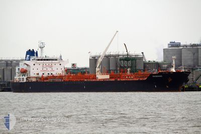
PERICLES
Oil/Chemical Tanker
Current Trip
SNDKR
| Time Travelled | 3 days |
|---|---|
| Remaining Time | --- |
| Distance Travelled | 919.70 nm |
| Remaining Distance | --- |
| AVG Speed | 11.6 Noeuds |
| MAX Speed | 13.2 Noeuds |
| AVG Wind | 16.6 knots |
| MAX Wind | 23 knots |
| MIN Temp | 17.1°C / 62.78°F |
| MAX Temp | 19.7°C / 67.46°F |
| Tirant d eau | 8.7 m |
| Position reçue | 1 h, 34 m depuis |
Current Position
| Longitude | -13.33098° |
|---|---|
| Latitude | 28.25190° |
| Etat | Under way using engine |
| Vitesse | 13 Noeuds |
| Parcours | 34° |
| Zone | North Atlantic Ocean |
| Station | T-AIS |
| Position reçue | 1 h, 34 m depuis |
Info
Information
The current position of PERICLES is in North Atlantic Ocean with coordinates 28.25190° / -13.33098° as reported on 2025-02-14 14:08 by AIS to our vessel tracker app. The vessel's current speed is 13 Noeuds
The vessel PERICLES (IMO: 9396488, MMSI: 636020929) is a Oil/Chemical Tanker that was built in 2007 ( 18 Age ). It's sailing under the flag of [LR] Liberia.
In this page you can find informations about the vessels current position, last detected port calls, and current voyage information. If the vessels is not in coverage by AIS you will find the latest position.
The current position of PERICLES is detected by our AIS receivers and we are not responsible for the reliability of the data. The last position was recorded while the vessel was in Coverage by the Ais receivers of our vessel tracking app.
The current draught of PERICLES as reported by AIS is 8.7 meters
Weather
| Temperature | 17.5°C / 63.5°F |
|---|---|
| Wind Speed | 7 knots |
| Direction | 55° NE |
| Pressure | 1015.7 hPa |
| Humidity | 75.7 % |
| Cloud Coverage | 1 % |
Featured Company
Events
| Heure | Evenement | Détails | Position/ Destination | Info |
|---|---|---|---|---|
| 2025-02-14 14:14 | Etat Changé | Default Under way using engine |
28.27117 / -13.31659
SNDKR
|
Vitesse: 13 kn Parcours: 34° |
| 2025-02-14 14:08 | Detecté en mer | Moroccan part of the North Atlantic Ocean |
28.25190 / -13.33098
North Atlantic Ocean
|
Vitesse: 13 kn Parcours: 34° |
| 2025-02-14 14:08 | Etat Changé | Under way using engine Default |
28.25190 / -13.33098
SNDKR
|
Vitesse: 13 kn Parcours: 34° |
| 2025-02-14 14:08 | Hors de la zone couverte |
28.25190 / -13.33098
North Atlantic Ocean
|
Vitesse: 13 kn Parcours: 34° |
|
| 2025-02-14 13:51 | Dans la zone couverte |
28.25190 / -13.33098
North Atlantic Ocean
|
Vitesse: 13 kn Parcours: 34° |
|
| 2025-02-14 13:03 | Etat Changé | Default Under way using engine |
28.06225 / -13.47757
SNDKR
|
Vitesse: 12.5 kn Parcours: 36.4° |
| 2025-02-14 12:57 | Hors de la zone couverte |
28.04530 / -13.49149
North Atlantic Ocean
|
Vitesse: 12.5 kn Parcours: 36.4° |
|
| 2025-02-14 12:55 | Etat Changé | Under way using engine Default |
28.03964 / -13.49611
SNDKR
|
Vitesse: 12.3 kn Parcours: 35° |
| 2025-02-14 12:51 | Etat Changé | Default Under way using engine |
28.02828 / -13.50526
SNDKR
|
Vitesse: 12.5 kn Parcours: 35.2° |
| 2025-02-14 12:09 | Changement de zone | Spanish (Canary Islands) part of the North Atlantic Ocean Moroccan part of the North Atlantic Ocean |
27.90481 / -13.59948
North Atlantic Ocean
|
Vitesse: 12.3 kn Parcours: 31.9° |