
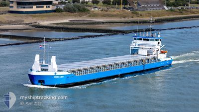
PRIMA LADY
General Cargo
Current Trip
| Trip Time | 1 day |
|---|---|
| Trip Distance | 252.86 nm |
| AVG Speed | 7.6 Noeuds |
| MAX Speed | 12.7 Noeuds |
| Tirant d eau | 4.4 m |
| AVG Wind | 18.6 knots |
| MAX Wind | 42 knots |
| MIN Temp | 5.6°C / 42.08°F |
| MAX Temp | 12°C / 53.6°F |
| Position reçue | 23 h, 46 m depuis |
Current Position
| Longitude | -6.12436° |
|---|---|
| Latitude | 54.03374° |
| Etat | Under way using engine |
| Vitesse | 9 Noeuds |
| Parcours | 311.9° |
| Zone | Irish Sea and St. George's Channel |
| Station | T-AIS |
| Position reçue | 23 h, 46 m depuis |
Info
Information
The current position of PRIMA LADY is in Irish Sea and St. George's Channel with coordinates 54.03374° / -6.12436° as reported on 2025-02-22 06:51 by AIS to our vessel tracker app. The vessel's current speed is 9 Noeuds and is currently inside the port of WARRENPOINT.
The vessel PRIMA LADY (IMO: 9195652, MMSI: 230693000) is a General Cargo that was built in 1999 ( 26 Age ). It's sailing under the flag of [FI] Finland.
In this page you can find informations about the vessels current position, last detected port calls, and current voyage information. If the vessels is not in coverage by AIS you will find the latest position.
The current position of PRIMA LADY is detected by our AIS receivers and we are not responsible for the reliability of the data. The last position was recorded while the vessel was in Coverage by the Ais receivers of our vessel tracking app.
The current draught of PRIMA LADY as reported by AIS is 4.4 meters
Weather
| Temperature | 8.8°C / 47.84°F |
|---|---|
| Wind Speed | 23 knots |
| Direction | 176° S |
| Pressure | 1003.7 hPa |
| Humidity | 82.9 % |
| Cloud Coverage | 100 % |
Featured Company
Last Port Calls
| Port | Arrival | Departure | Time In Port |
|---|---|---|---|
| 2025-02-22 07:31 | |||
| 2025-02-19 21:15 | 2025-02-20 23:20 | 1 d | |
| 2025-02-08 09:29 | 2025-02-12 13:21 | 4 d | |
| 2025-02-07 11:20 | 2025-02-07 20:24 | 9 h | |
| 2025-02-06 14:09 | 2025-02-06 20:09 | 5 h | |
| 2025-02-02 22:25 | 2025-02-05 23:36 | 3 d | |
| 2025-01-31 12:24 | 2025-02-01 21:37 | 1 d | |
| 2025-01-30 13:37 | 2025-01-31 10:05 | 20 h | |
| 2025-01-27 10:57 | 2025-01-28 10:30 | 23 h | |
| 2025-01-23 21:04 | 2025-01-24 21:23 | 1 d |
Last Trips
| Origin | Departure | Destination | Arrival | Distance | |
|---|---|---|---|---|---|
| 2025-02-20 23:20 | 2025-02-22 07:31 | 252.86 nm | |||
| 2025-02-12 14:21 | 2025-02-19 21:15 | 1553.12 nm | |||
| 2025-02-07 22:24 | 2025-02-08 10:29 | 140.42 nm | |||
| 2025-02-06 21:09 | 2025-02-07 13:20 | 139.83 nm | |||
| 2025-02-06 01:36 | 2025-02-06 15:09 | 141.57 nm | |||
| 2025-02-01 23:37 | 2025-02-03 00:25 | 220.39 nm | |||
| 2025-01-31 12:05 | 2025-01-31 14:24 | 24.88 nm | |||
| 2025-01-28 12:30 | 2025-01-30 15:37 | 319.18 nm | |||
| 2025-01-24 23:23 | 2025-01-27 12:57 | 487.89 nm | |||
| 2025-01-20 10:26 | 2025-01-23 23:04 | 785.07 nm |
Events
| Heure | Evenement | Détails | Position/ Destination | Info |
|---|---|---|---|---|
| 2025-02-22 07:43 | Arret |
54.09970 / -6.25993
[GB] WARRENPOINT
|
Vitesse: 0.2 kn Parcours: 131° |
|
| 2025-02-22 07:31 | Port d'arrivée |
|
54.09632 / -6.25596
[GB] WARRENPOINT
|
Vitesse: 6.5 kn Parcours: 308° |
| 2025-02-22 06:51 | Etat Changé | Default Under way using engine |
54.03399 / -6.12485
WARRENPOINT
|
Vitesse: 9 kn Parcours: 311.9° |
| 2025-02-22 06:51 | Changement de zone | Irish part of the Irish Sea and St. George's Channel United Kingdom part of the Irish Sea and St. George's Channel |
54.03374 / -6.12436
Irish Sea and St. George's Channel
WARRENPOINT
|
Vitesse: 9 kn Parcours: 311.9° |
| 2025-02-22 06:51 | Hors de la zone couverte |
54.03374 / -6.12436
Irish Sea and St. George's Channel
[GB] WARRENPOINT
|
Vitesse: 9 kn Parcours: 311.9° |
|
| 2025-02-22 06:46 | Etat Changé | Under way using engine Default |
54.02861 / -6.10778
WARRENPOINT
|
Vitesse: 9.3 kn Parcours: 289° |
| 2025-02-22 06:43 | Etat Changé | Default Under way using engine |
54.02642 / -6.09565
WARRENPOINT
|
Vitesse: 8.9 kn Parcours: 310.4° |
| 2025-02-22 06:19 | Changement d'ETA | 2025/02/22 06:00 2025/02/21 21:00 |
53.98679 / -6.02116
WARRENPOINT
|
Vitesse: 8.6 kn Parcours: 327.4° |
| 2025-02-22 06:16 | Etat Changé | Under way using engine Default |
53.98123 / -6.01534
WARRENPOINT
|
Vitesse: 7 kn Parcours: 326° |
| 2025-02-22 05:55 | Etat Changé | Default Under way using engine |
53.94815 / -5.99132
WARRENPOINT
|
Vitesse: 5.6 kn Parcours: 344.4° |