
REMAH
Cargo
Current Trip
| Time Travelled | 3 days |
|---|---|
| Remaining Time | 11 h, 11 mins |
| Distance Travelled | 1180.82 nm |
| Remaining Distance | 167.68 nm |
| AVG Speed | 14.9 Noeuds |
| MAX Speed | 15.5 Noeuds |
| AVG Wind | 11 knots |
| MAX Wind | 27.8 knots |
| MIN Temp | 9.6°C / 49.28°F |
| MAX Temp | 14.8°C / 58.64°F |
| Tirant d eau | 9.4 m |
| Position reçue | 2 m depuis |
Current Position
| Longitude | 24.08506° |
|---|---|
| Latitude | 37.46747° |
| Etat | Under way using engine |
| Vitesse | 14.6 Noeuds |
| Parcours | 34.4° |
| Zone | Aegean Sea |
| Station | T-AIS |
| Position reçue | 2 m depuis |
Info
Information
The current position of REMAH is in Aegean Sea with coordinates 37.46747° / 24.08506° as reported on 2025-02-06 10:48 by AIS to our vessel tracker app. The vessel's current speed is 14.6 Noeuds and is heading at the port of NEMRUT. The estimated time of arrival as calculated by MyShipTracking vessel tracking app is 2025-02-06 22:01 LT
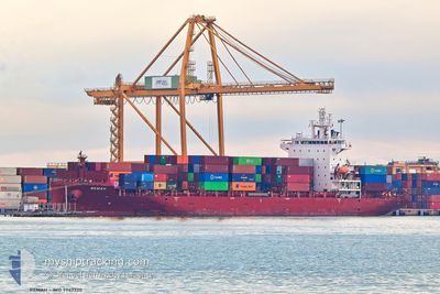
The vessel REMAH (IMO: 9947720, MMSI: 538010343) is a Cargo It's sailing under the flag of [MH] Marshall Is.
In this page you can find informations about the vessels current position, last detected port calls, and current voyage information. If the vessels is not in coverage by AIS you will find the latest position.
The current position of REMAH is detected by our AIS receivers and we are not responsible for the reliability of the data. The last position was recorded while the vessel was in Coverage by the Ais receivers of our vessel tracking app.
The current draught of REMAH as reported by AIS is 9.4 meters
Weather
| Temperature | 9.6°C / 49.28°F |
|---|---|
| Wind Speed | 16 knots |
| Direction | 15° NNE |
| Pressure | 1031.1 hPa |
| Humidity | 59 % |
| Cloud Coverage | 71 % |
Featured Company
Last Port Calls
| Port | Arrival | Departure | Time In Port |
|---|---|---|---|
| 2025-02-02 10:12 | 2025-02-03 03:50 | 17 h | |
| 2025-01-31 10:14 | 2025-02-01 18:41 | 1 d | |
| 2025-01-24 09:44 | 2025-01-26 22:45 | 2 d | |
| 2025-01-20 22:02 | 2025-01-22 07:16 | 1 d | |
| 2025-01-18 05:43 | 2025-01-18 19:56 | 14 h | |
| 2025-01-13 09:29 | 2025-01-13 19:48 | 10 h | |
| 2025-01-11 11:42 | 2025-01-12 02:03 | 14 h | |
| 2025-01-07 08:53 | 2025-01-07 18:09 | 9 h | |
| 2025-01-03 18:53 | 2025-01-04 15:17 | 20 h | |
| 2025-01-03 06:38 | 2025-01-03 07:35 | 57 m |
Most Visited Ports (Last year)
| Port | Arrivals | |
|---|---|---|
| 17 | ||
| 15 | ||
| 10 | ||
| 2 | ||
| 2 | ||
| 1 |
Last Trips
| Origin | Departure | Destination | Arrival | Distance | |
|---|---|---|---|---|---|
| 2025-02-01 19:41 | 2025-02-02 11:12 | 179.93 nm | |||
| 2025-01-26 23:45 | 2025-01-31 11:14 | 623.12 nm | |||
| 2025-01-22 08:16 | 2025-01-24 10:44 | 602.29 nm | |||
| 2025-01-18 20:56 | 2025-01-20 23:02 | 177.84 nm | |||
| 2025-01-13 22:48 | 2025-01-18 06:43 | 1392.18 nm | |||
| 2025-01-12 05:03 | 2025-01-13 12:29 | 278.16 nm | |||
| 2025-01-04 18:17 | 2025-01-11 14:42 | 1627.74 nm | |||
| 2025-01-04 18:17 | 2025-01-07 10:53 | 643.17 nm | |||
| 2025-01-03 09:35 | 2025-01-03 21:53 | 160.02 nm | |||
| 2025-01-03 06:33 | 2025-01-03 08:38 | 27.53 nm |
Events
| Heure | Evenement | Détails | Position/ Destination | Info |
|---|---|---|---|---|
| 2025-02-06 08:51 | Etat Changé | Under way using engine Default |
37.09159 / 23.72107
NEMPORT
|
Vitesse: 14.8 kn Parcours: 21° |
| 2025-02-06 08:51 | Dans la zone couverte |
37.12326 / 23.75120
Aegean Sea
NEMPORT
|
Vitesse: 14.7 kn Parcours: 39.1° |
|
| 2025-02-06 07:55 | Etat Changé | Default Under way using engine |
36.88073 / 23.59863
NEMPORT
|
Vitesse: 15 kn Parcours: 25.5° |
| 2025-02-06 07:52 | Hors de la zone couverte |
36.86943 / 23.59187
Aegean Sea
NEMPORT
|
Vitesse: 15 kn Parcours: 25.5° |
|
| 2025-02-06 07:37 | Etat Changé | Under way using engine Default |
36.81209 / 23.55826
NEMPORT
|
Vitesse: 14.7 kn Parcours: 27° |
| 2025-02-06 07:01 | Etat Changé | Default Under way using engine |
36.68103 / 23.47515
NEMPORT
|
Vitesse: 14.7 kn Parcours: 23.1° |
| 2025-02-06 06:49 | Changement de zone | Greek part of the Aegean Sea Maltese part of the Mediterranean Sea - Eastern Basin |
36.63635 / 23.44949
Aegean Sea
NEMPORT
|
Vitesse: 14.7 kn Parcours: 23.2° |
| 2025-02-06 06:49 | Etat Changé | Under way using engine Default |
36.63560 / 23.44909
NEMPORT
|
Vitesse: 14.3 kn Parcours: 23° |
| 2025-02-06 06:49 | Dans la zone couverte |
36.63635 / 23.44949
Aegean Sea
NEMPORT
|
Vitesse: 14.7 kn Parcours: 23.2° |
|
| 2025-02-04 23:50 | Hors de la zone couverte |
36.25804 / 14.48940
Mediterranean Sea - Eastern Basin
NEMPORT
|
Vitesse: 14.8 kn Parcours: 120.1° |