
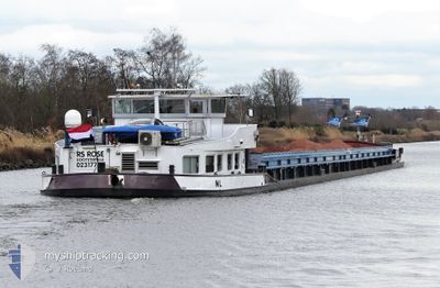
RS ROSE
Other Type
Current Trip
| Trip Time | 6 h, 34 mins |
|---|---|
| Trip Distance | 44.42 nm |
| AVG Speed | 6.7 Noeuds |
| MAX Speed | 8.2 Noeuds |
| Tirant d eau | 0 m |
| AVG Wind | 14.7 knots |
| MAX Wind | 21 knots |
| MIN Temp | -0.5°C / 31.1°F |
| MAX Temp | 3.6°C / 38.48°F |
| Position reçue | 1 m depuis |
Current Position
| Longitude | 4.85730° |
|---|---|
| Latitude | 52.40068° |
| Etat | Moored |
| Vitesse | 0.1 Noeuds |
| Parcours | --- |
| Zone | North Sea |
| Station | T-AIS |
| Position reçue | 1 m depuis |
Info
Information
The current position of RS ROSE is in North Sea with coordinates 52.40068° / 4.85730° as reported on 2026-01-07 19:00 by AIS to our vessel tracker app. The vessel's current speed is 0.1 Noeuds and is currently inside the port of AMSTERDAM.
The vessel RS ROSE (MMSI: 244130211) is a Other Type It's sailing under the flag of [NL] Netherlands.
In this page you can find informations about the vessels current position, last detected port calls, and current voyage information. If the vessels is not in coverage by AIS you will find the latest position.
The current position of RS ROSE is detected by our AIS receivers and we are not responsible for the reliability of the data. The last position was recorded while the vessel was in Coverage by the Ais receivers of our vessel tracking app.
Weather
| Temperature | 3.5°C / 38.3°F |
|---|---|
| Wind Speed | 10 knots |
| Direction | 261° W |
| Pressure | 1001.1 hPa |
| Humidity | 91.8 % |
| Cloud Coverage | 100 % |
Featured Company
Last Port Calls
| Port | Arrival | Departure | Time In Port |
|---|---|---|---|
| 2026-01-07 19:36 | |||
| 2026-01-07 01:14 | 2026-01-07 13:02 | 11 h | |
| 2026-01-06 17:07 | 2026-01-06 17:42 | 35 m | |
| 2026-01-06 00:34 | 2026-01-06 13:14 | 12 h | |
| 2026-01-05 19:19 | 2026-01-05 20:09 | 49 m | |
| 2025-12-31 14:37 | 2026-01-05 10:07 | 4 d | |
| 2025-12-30 13:06 | 2025-12-30 13:52 | 45 m | |
| 2025-12-29 16:32 | 2025-12-30 09:55 | 17 h | |
| 2025-12-29 15:58 | |||
| 2025-12-28 12:43 | 2025-12-28 13:06 | 23 m |
Most Visited Ports (Last year)
| Port | Arrivals | |
|---|---|---|
| 38 | ||
| 33 | ||
| 33 | ||
| 19 | ||
| 16 | ||
| 11 |
Last Trips
| Origin | Departure | Destination | Arrival | Distance | |
|---|---|---|---|---|---|
| 2026-01-07 13:02 | 2026-01-07 19:36 | 44.42 nm | |||
| 2026-01-06 17:42 | 2026-01-07 01:14 | 62.69 nm | |||
| 2026-01-06 13:14 | 2026-01-06 17:07 | 33.49 nm | |||
| 2026-01-05 20:09 | 2026-01-06 00:34 | 35.60 nm | |||
| 2026-01-05 10:07 | 2026-01-05 19:19 | 63.35 nm | |||
| 2025-12-30 13:52 | 2025-12-31 14:37 | 62.52 nm | |||
| 2025-12-30 09:55 | 2025-12-30 13:06 | 23.44 nm | |||
| 2025-12-29 15:58 | 2025-12-29 16:32 | 1.22 nm | |||
| 2025-12-27 12:02 | 2025-12-28 12:43 | 64.58 nm | |||
| 2025-12-23 17:47 | 2025-12-24 03:30 | 70.77 nm |
Events
| Heure | Evenement | Détails | Position/ Destination | Info |
|---|---|---|---|---|
| 2026-01-07 18:55 | Etat Changé | Moored Under way using engine |
52.40067 / 4.85729
[NL] AMSTERDAM
|
Vitesse: Parcours: 511° |
| 2026-01-07 18:36 | Arret |
52.40090 / 4.85703
[NL] AMSTERDAM
|
Vitesse: 0.3 kn Parcours: 511° |
|
| 2026-01-07 18:36 | Port d'arrivée |
|
52.40090 / 4.85703
[NL] AMSTERDAM
|
Vitesse: 0.6 kn Parcours: 511° |
| 2026-01-07 17:48 | Démarrage | 0.23 nm, West of SCHELLINGWOUDE |
52.38036 / 4.95854
AMERIKAHAVEN
|
Vitesse: 3.9 kn Parcours: 293.4° |
| 2026-01-07 17:35 | Arret | 0.15 nm, South West of SCHELLINGWOUDE |
52.37966 / 4.96141
AMERIKAHAVEN
|
Vitesse: 0.2 kn Parcours: 511° |
| 2026-01-07 14:46 | Démarrage | 0.18 nm, West of LELYSTAD |
52.52613 / 5.43388
AMERIKAHAVEN
|
Vitesse: 3.2 kn Parcours: 185.2° |
| 2026-01-07 14:39 | Arret | 0.21 nm, North West of LELYSTAD |
52.52827 / 5.43411
AMERIKAHAVEN
|
Vitesse: 0.3 kn Parcours: 511° |
| 2026-01-07 13:37 | Changement d'ETA | 2026/12/09 11:09 |
52.60584 / 5.57541
AMERIKAHAVEN
|
Vitesse: 7.5 kn Parcours: 253.3° |
| 2026-01-07 13:25 | Changement d'ETA | 2026/12/09 11:09 |
52.61223 / 5.61494
AMERIKAHAVEN
|
Vitesse: 7.4 kn Parcours: 252.1° |
| 2026-01-07 13:19 | Changement d'ETA | 2026/12/09 11:09 |
52.61513 / 5.63498
AMERIKAHAVEN
|
Vitesse: 7.5 kn Parcours: 263.6° |