

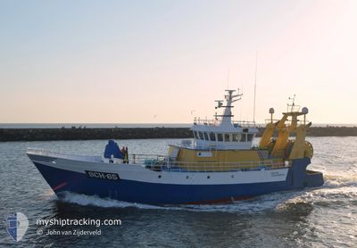
SCH65 SIMPLON
Trawler

Current Trip
| Trip Time | 3 h, 14 mins |
|---|---|
| Trip Distance | 27.92 nm |
| AVG Speed | 9.6 Noeuds |
| MAX Speed | 12.7 Noeuds |
| Tirant d eau | 5 m |
| AVG Wind | 14.4 knots |
| MAX Wind | 17.8 knots |
| MIN Temp | 19.2°C / 66.56°F |
| MAX Temp | 26.9°C / 80.42°F |
| Position reçue | Maintenant |
Current Position
| Longitude | 4.26653° |
|---|---|
| Latitude | 52.10139° |
| Etat | Engaged in Fishing |
| Vitesse | |
| Parcours | 220° |
| Zone | North Sea |
| Station | T-AIS |
| Position reçue | Maintenant |
Information
The current position of SCH65 SIMPLON is in North Sea with coordinates 52.10139° / 4.26653° as reported on 2025-06-13 01:10 by AIS to our vessel tracker app. The vessel's current speed is 0 Noeuds and is currently inside the port of SCHEVENINGEN.
The vessel SCH65 SIMPLON (IMO: 8108688, MMSI: 246742000) is a Trawler that was built in 1982 ( 43 Age ). It's sailing under the flag of [NL] Netherlands.
In this page you can find informations about the vessels current position, last detected port calls, and current voyage information. If the vessels is not in coverage by AIS you will find the latest position.
The current position of SCH65 SIMPLON is detected by our AIS receivers and we are not responsible for the reliability of the data. The last position was recorded while the vessel was in Coverage by the Ais receivers of our vessel tracking app.
The current draught of SCH65 SIMPLON as reported by AIS is 5 meters
Weather
| Temperature | 19°C / 66.2°F |
|---|---|
| Wind Speed | 4 knots |
| Direction | 242° WSW |
| Pressure | 1016.5 hPa |
| Humidity | 82.4 % |
| Cloud Coverage | 14 % |


Featured Company
Last Port Calls
| Port | Arrival | Departure | Time In Port |
|---|---|---|---|
| 2025-06-12 17:19 | |||
| 2025-06-11 15:44 | 2025-06-12 14:05 | 22 h | |
| 2025-05-07 22:42 | 2025-06-11 15:08 | ||
| 2025-05-04 23:22 | 2025-05-05 02:25 | 3 h | |
| 2025-04-30 20:01 | 2025-05-01 00:20 | 4 h | |
| 2025-04-13 06:47 | 2025-04-13 09:22 | 2 h | |
| 2025-04-03 19:35 | 2025-04-10 01:19 | 6 d |
Most Visited Ports (Last year)
| Port | Arrivals | |
|---|---|---|
| 64 | ||
| 4 | ||
| 3 | ||
| 1 | ||
| 1 |
Last Trips
| Origin | Departure | Destination | Arrival | Distance | |
|---|---|---|---|---|---|
| 2025-06-12 14:05 | 2025-06-12 17:19 | 27.92 nm | |||
| 2025-06-11 15:08 | 2025-06-11 15:44 | 4.27 nm | |||
| 2025-05-05 02:25 | 2025-05-07 22:42 | 129.48 nm | |||
| 2025-05-01 00:20 | 2025-05-04 23:22 | 281.15 nm | |||
| 2025-04-13 09:22 | 2025-04-30 20:01 | 607.92 nm | |||
| 2025-04-10 01:19 | 2025-04-13 06:47 | 362.59 nm | |||
| 2025-03-31 00:51 | 2025-04-03 19:35 | 311.40 nm |
Events
| Heure | Evenement | Détails | Position/ Destination | Info |
|---|---|---|---|---|
| 2025-06-12 21:13 | Dans la zone couverte |
52.10138 / 4.26646
North Sea
[NL] SCHEVENINGEN
|
Vitesse: Parcours: 0° |
|
| 2025-06-12 17:06 | Hors de la zone couverte |
52.10139 / 4.26647
North Sea
[NL] SCHEVENINGEN
|
Vitesse: Parcours: 0° |
|
| 2025-06-12 15:30 | Arret |
52.10136 / 4.26648
[NL] SCHEVENINGEN
|
Vitesse: Parcours: 221° |
|
| 2025-06-12 15:19 | Port d'arrivée |
|
52.10388 / 4.25403
[NL] SCHEVENINGEN
|
Vitesse: 9.3 kn Parcours: 145.7° |
| 2025-06-12 14:27 | Dans la zone couverte |
52.01827 / 4.01332
North Sea
|
Vitesse: 12.6 kn Parcours: 57.5° |
|
| 2025-06-12 13:11 | Hors de la zone couverte |
51.88922 / 3.85805
North Sea
|
Vitesse: 11.3 kn Parcours: 3.2° |
|
| 2025-06-12 12:14 | Dans la zone couverte |
51.85032 / 4.03155
North Sea
|
Vitesse: 7.6 kn Parcours: 321.3° |
|
| 2025-06-12 12:05 | PORT DE DEPART |
|
51.84593 / 4.03465
IHING GROUND
|
Vitesse: Parcours: 218° |
| 2025-06-12 10:21 | Hors de la zone couverte |
51.82508 / 4.03392
North Sea
[NL] STELLENDAM
|
Vitesse: Parcours: 0° |
|
| 2025-06-11 21:52 | Dans la zone couverte |
51.82517 / 4.03365
North Sea
[NL] STELLENDAM
|
Vitesse: Parcours: 0° |