

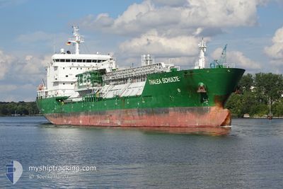
THALEA SCHULTE
Tanker

Current Trip
| Time Travelled | 46 days |
|---|---|
| Remaining Time | --- |
| Distance Travelled | 4237.53 nm |
| Remaining Distance | --- |
| AVG Speed | 11.2 Noeuds |
| MAX Speed | 15.5 Noeuds |
| AVG Wind | 6.9 knots |
| MAX Wind | 19.8 knots |
| MIN Temp | 25°C / 77°F |
| MAX Temp | 31.1°C / 87.98°F |
| Tirant d eau | 6.6 m |
| Position reçue | 4 h, 25 m depuis |
Current Position
| Longitude | 104.27702° |
|---|---|
| Latitude | 1.33153° |
| Etat | At anchor |
| Vitesse | 0.1 Noeuds |
| Parcours | 281° |
| Zone | Singapore Strait |
| Station | T-AIS |
| Position reçue | 4 h, 25 m depuis |
Information
The current position of THALEA SCHULTE is in Singapore Strait with coordinates 1.33153° / 104.27702° as reported on 2025-06-09 23:16 by AIS to our vessel tracker app. The vessel's current speed is 0.1 Noeuds
The vessel THALEA SCHULTE (IMO: 9542984, MMSI: 563091400) is a Tanker It's sailing under the flag of [SG] Singapore.
In this page you can find informations about the vessels current position, last detected port calls, and current voyage information. If the vessels is not in coverage by AIS you will find the latest position.
The current position of THALEA SCHULTE is detected by our AIS receivers and we are not responsible for the reliability of the data. The last position was recorded while the vessel was in Coverage by the Ais receivers of our vessel tracking app.
The current draught of THALEA SCHULTE as reported by AIS is 6.6 meters
Weather
| Temperature | 27.7°C / 81.86°F |
|---|---|
| Wind Speed | 12 knots |
| Direction | 267° W |
| Pressure | 1009.8 hPa |
| Humidity | 77.6 % |
| Cloud Coverage | 100 % |


Featured Company
Last Port Calls
| Port | Arrival | Departure | Time In Port |
|---|---|---|---|
| 2025-04-23 20:33 | 2025-04-25 02:29 | 1 d | |
| 2025-04-09 22:31 | 2025-04-11 08:53 | 1 d | |
| 2025-04-04 22:56 | 2025-04-06 14:05 | 1 d |
Last Trips
| Origin | Departure | Destination | Arrival | Distance | |
|---|---|---|---|---|---|
| 2025-04-11 08:53 | 2025-04-23 20:33 | 2290.95 nm | |||
| 2025-04-06 14:05 | 2025-04-09 22:31 | 617.78 nm | |||
| 2025-02-20 01:20 | 2025-04-04 22:56 | 315.29 nm |
Events
| Heure | Evenement | Détails | Position/ Destination | Info |
|---|---|---|---|---|
| 2025-06-09 23:22 | Etat Changé | Default At anchor |
1.33170 / 104.27705
MY PGG
|
Vitesse: 0.1 kn Parcours: 281° |
| 2025-06-09 23:16 | Etat Changé | At anchor Default |
1.33153 / 104.27702
MY PGG
|
Vitesse: 0.4 kn Parcours: 263° |
| 2025-06-09 23:16 | Hors de la zone couverte |
1.33153 / 104.27702
Singapore Strait
|
Vitesse: 0.1 kn Parcours: 162.9° |
|
| 2025-06-09 22:39 | Tirant d'eau modifié | 6.6 6.5 |
1.33182 / 104.27711
MY PGG
|
Vitesse: 0.1 kn Parcours: 264° |
| 2025-06-09 22:39 | Changement de destination | MY PGG ID MRK |
1.33182 / 104.27711
MY PGG
|
Vitesse: 0.1 kn Parcours: 264° |
| 2025-06-09 22:39 | Changement d'ETA | 2025/06/09 16:00 2025/06/01 02:00 |
1.33182 / 104.27711
MY PGG
|
Vitesse: 0.1 kn Parcours: 264° |
| 2025-06-09 22:34 | Etat Changé | Default At anchor |
1.33182 / 104.27711
ID MRK
|
Vitesse: 0.3 kn Parcours: 270° |
| 2025-06-09 22:28 | Etat Changé | At anchor Default |
1.33178 / 104.27709
ID MRK
|
Vitesse: 0.2 kn Parcours: 277° |
| 2025-06-09 21:58 | Etat Changé | Default At anchor |
1.33215 / 104.27710
ID MRK
|
Vitesse: 0.5 kn Parcours: 257° |
| 2025-06-09 21:52 | Etat Changé | At anchor Default |
1.33191 / 104.27707
ID MRK
|
Vitesse: 0.4 kn Parcours: 266° |