
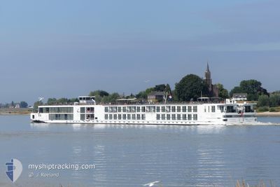
VIKING HERVOR
Passenger
Current Trip
| Time Travelled | 2 days |
|---|---|
| Remaining Time | --- |
| Distance Travelled | 174.27 nm |
| Remaining Distance | --- |
| AVG Speed | 9.9 Noeuds |
| MAX Speed | 12.6 Noeuds |
| AVG Wind | 10 knots |
| MAX Wind | 15.8 knots |
| MIN Temp | 13.2°C / 55.76°F |
| MAX Temp | 20.5°C / 68.9°F |
| Tirant d eau | 1.7 m |
| Position reçue | 34 m depuis |
Current Position
| Longitude | 8.00789° |
|---|---|
| Latitude | 49.99054° |
| Etat | Under way using engine |
| Vitesse | 9.2 Noeuds |
| Parcours | 246.5° |
| Zone | North Sea |
| Station | T-AIS |
| Position reçue | 34 m depuis |
Information
The current position of VIKING HERVOR is in North Sea with coordinates 49.99054° / 8.00789° as reported on 2025-06-08 14:15 by AIS to our vessel tracker app. The vessel's current speed is 9.2 Noeuds and is heading at the port of AMSTERDAM. The estimated time of arrival as calculated by MyShipTracking vessel tracking app is 2025-06-12 02:00 LT
The vessel VIKING HERVOR (MMSI: 269087721) is a Passenger It's sailing under the flag of [CH] Switzerland.
In this page you can find informations about the vessels current position, last detected port calls, and current voyage information. If the vessels is not in coverage by AIS you will find the latest position.
The current position of VIKING HERVOR is detected by our AIS receivers and we are not responsible for the reliability of the data. The last position was recorded while the vessel was in Coverage by the Ais receivers of our vessel tracking app.
The current draught of VIKING HERVOR as reported by AIS is 1.7 meters
Weather
| Temperature | 16.5°C / 61.7°F |
|---|---|
| Wind Speed | 15 knots |
| Direction | 280° W |
| Pressure | 1016.4 hPa |
| Humidity | 53.3 % |
| Cloud Coverage | 54 % |
Featured Company
Last Port Calls
| Port | Arrival | Departure | Time In Port |
|---|---|---|---|
| 2025-06-05 16:12 | 2025-06-05 16:38 | 25 m | |
| 2025-06-04 22:43 | 2025-06-05 16:01 | 17 h | |
| 2025-05-31 08:14 | 2025-05-31 20:39 | 12 h | |
| 2025-05-30 10:26 | 2025-05-30 10:57 | 31 m | |
| 2025-05-30 01:03 | 2025-05-30 01:17 | 13 m | |
| 2025-05-28 23:28 | 2025-05-29 22:02 | 22 h | |
| 2025-05-28 20:41 | 2025-05-28 21:16 | 34 m | |
| 2025-05-28 19:25 | 2025-05-28 20:29 | 1 h | |
| 2025-05-28 10:26 | 2025-05-28 12:01 | 1 h | |
| 2025-05-27 06:12 | 2025-05-27 20:35 | 14 h |
Most Visited Ports (Last year)
| Port | Arrivals | |
|---|---|---|
| 47 | ||
| 40 | ||
| 39 | ||
| 24 | ||
| 24 | ||
| 23 |
Last Trips
| Origin | Departure | Destination | Arrival | Distance | |
|---|---|---|---|---|---|
| 2025-06-05 18:01 | 2025-06-05 18:12 | 0.87 nm | |||
| 2025-05-31 22:39 | 2025-06-05 00:43 | 259.22 nm | |||
| 2025-05-30 12:57 | 2025-05-31 10:14 | 139.28 nm | |||
| 2025-05-30 03:17 | 2025-05-30 12:26 | 38.20 nm | |||
| 2025-05-30 00:02 | 2025-05-30 03:03 | 23.63 nm | |||
| 2025-05-28 23:16 | 2025-05-29 01:28 | 16.96 nm | |||
| 2025-05-28 22:29 | 2025-05-28 22:41 | 0.68 nm | |||
| 2025-05-28 14:01 | 2025-05-28 21:25 | 37.35 nm | |||
| 2025-05-27 22:35 | 2025-05-28 12:26 | 137.92 nm | |||
| 2025-05-22 19:08 | 2025-05-27 08:12 | 260.11 nm |
Events
| Heure | Evenement | Détails | Position/ Destination | Info |
|---|---|---|---|---|
| 2025-06-08 10:56 | Dans la zone couverte |
49.74469 / 8.45795
North Sea
AMSTERDAM
|
Vitesse: 10.8 kn Parcours: 39.7° |
|
| 2025-06-08 08:54 | Hors de la zone couverte |
49.57893 / 8.42484
North Sea
AMSTERDAM
|
Vitesse: 10.3 kn Parcours: 3.9° |
|
| 2025-06-08 08:54 | Etat Changé | Under way using engine Default |
49.57893 / 8.42484
AMSTERDAM
|
Vitesse: 11.1 kn Parcours: 30° |
| 2025-06-08 08:50 | Etat Changé | Default Under way using engine |
49.56910 / 8.41831
AMSTERDAM
|
Vitesse: 10.4 kn Parcours: 357.7° |
| 2025-06-08 06:56 | Dans la zone couverte |
49.31417 / 8.45437
North Sea
AMSTERDAM
|
Vitesse: 2.5 kn Parcours: 129.8° |
|
| 2025-06-08 02:57 | Hors de la zone couverte |
49.31460 / 8.45354
North Sea
AMSTERDAM
|
Vitesse: Parcours: 228.6° |
|
| 2025-06-08 00:21 | Etat Changé | Moored Under way using engine |
49.31461 / 8.45353
AMSTERDAM
|
Vitesse: 0.2 kn Parcours: 144° |
| 2025-06-07 23:34 | Arret | 6.08 nm, North East of GERMERSHEIM |
49.31455 / 8.45356
AMSTERDAM
|
Vitesse: 0.2 kn Parcours: 144° |
| 2025-06-07 23:16 | Dans la zone couverte |
49.28838 / 8.48627
North Sea
AMSTERDAM
|
Vitesse: 11.4 kn Parcours: 42.1° |
|
| 2025-06-05 20:11 | Hors de la zone couverte |
47.80237 / 7.53527
North Sea
AMSTERDAM
|
Vitesse: 9.9 kn Parcours: 24.5° |