
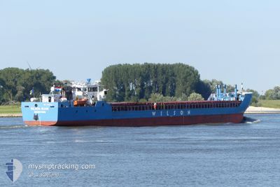
WILSON RUHR
General Cargo
Current Trip
| Time Travelled | 1 day |
|---|---|
| Remaining Time | 6 h, 5 mins |
| Distance Travelled | 186.61 nm |
| Remaining Distance | 41.58 nm |
| AVG Speed | 7.8 Noeuds |
| MAX Speed | 11.5 Noeuds |
| AVG Wind | 11.9 knots |
| MAX Wind | 18.2 knots |
| MIN Temp | 4.7°C / 40.46°F |
| MAX Temp | 7.5°C / 45.5°F |
| Tirant d eau | 3.5 m |
| Position reçue | Maintenant |
Current Position
| Longitude | 0.10334° |
|---|---|
| Latitude | 53.56849° |
| Etat | Under way using engine |
| Vitesse | 6.6 Noeuds |
| Parcours | 297.7° |
| Zone | North Sea |
| Station | T-AIS |
| Position reçue | Maintenant |
Info
Information
The current position of WILSON RUHR is in North Sea with coordinates 53.56849° / 0.10334° as reported on 2025-02-09 11:22 by AIS to our vessel tracker app. The vessel's current speed is 6.6 Noeuds and is heading at the port of GUNNESS. The estimated time of arrival as calculated by MyShipTracking vessel tracking app is 2025-02-09 17:27 LT
The vessel WILSON RUHR (IMO: 9145542, MMSI: 314218000) is a General Cargo that was built in 1997 ( 28 Age ). It's sailing under the flag of [BB] Barbados.
In this page you can find informations about the vessels current position, last detected port calls, and current voyage information. If the vessels is not in coverage by AIS you will find the latest position.
The current position of WILSON RUHR is detected by our AIS receivers and we are not responsible for the reliability of the data. The last position was recorded while the vessel was in Coverage by the Ais receivers of our vessel tracking app.
The current draught of WILSON RUHR as reported by AIS is 3.5 meters
Weather
| Temperature | 6.6°C / 43.88°F |
|---|---|
| Wind Speed | 16 knots |
| Direction | 61° ENE |
| Pressure | 1032.2 hPa |
| Humidity | 87.9 % |
| Cloud Coverage | 89 % |
Featured Company
Last Port Calls
| Port | Arrival | Departure | Time In Port |
|---|---|---|---|
| 2025-02-08 04:47 | 2025-02-08 10:24 | 5 h | |
| 2025-02-06 23:36 | 2025-02-08 04:24 | 1 d | |
| 2025-02-02 08:57 | 2025-02-04 09:40 | 2 d | |
| 2025-01-31 20:47 | 2025-01-31 21:45 | 58 m | |
| 2025-01-30 09:25 | 2025-01-31 19:25 | 1 d | |
| 2025-01-28 05:01 | 2025-01-29 10:16 | 1 d | |
| 2025-01-18 07:45 | 2025-01-24 10:23 | 6 d | |
| 2025-01-11 12:55 | 2025-01-11 18:02 | 5 h | |
| 2025-01-09 04:44 | 2025-01-09 05:50 | 1 h | |
| 2025-01-08 04:49 | 2025-01-08 18:27 | 13 h |
Last Trips
| Origin | Departure | Destination | Arrival | Distance | |
|---|---|---|---|---|---|
| 2025-02-08 05:24 | 2025-02-08 05:47 | 1.11 nm | |||
| 2025-02-04 09:40 | 2025-02-07 00:36 | 243.37 nm | |||
| 2025-01-31 22:45 | 2025-02-02 08:57 | 229.60 nm | |||
| 2025-01-31 20:25 | 2025-01-31 21:47 | 7.65 nm | |||
| 2025-01-29 10:16 | 2025-01-30 10:25 | 196.43 nm | |||
| 2025-01-24 11:23 | 2025-01-28 05:01 | 618.23 nm | |||
| 2025-01-11 19:02 | 2025-01-18 08:45 | 791.56 nm | |||
| 2025-01-09 06:50 | 2025-01-11 13:55 | 469.30 nm | |||
| 2025-01-08 19:27 | 2025-01-09 05:44 | 111.62 nm | |||
| 2025-01-07 12:33 | 2025-01-08 05:49 | 113.78 nm |
Events
| Heure | Evenement | Détails | Position/ Destination | Info |
|---|---|---|---|---|
| 2025-02-09 10:11 | Etat Changé | Under way using engine Default |
53.52549 / .30349
GBGRW
|
Vitesse: 5.8 kn Parcours: 307° |
| 2025-02-09 09:49 | Etat Changé | Default Under way using engine |
53.50632 / .35290
GBGRW
|
Vitesse: 5.2 kn Parcours: 302.5° |
| 2025-02-09 09:44 | Etat Changé | Under way using engine Default |
53.50214 / .36374
GBGRW
|
Vitesse: 4.8 kn Parcours: 303° |
| 2025-02-09 09:41 | Etat Changé | Default Under way using engine |
53.49976 / .36976
GBGRW
|
Vitesse: 3.8 kn Parcours: 301° |
| 2025-02-09 08:23 | Etat Changé | Under way using engine Default |
53.44154 / .48504
GBGRW
|
Vitesse: 3.4 kn Parcours: 340° |
| 2025-02-09 08:07 | Dans la zone couverte |
53.44407 / .48258
North Sea
GBGRW
|
Vitesse: 4.1 kn Parcours: 325.9° |
|
| 2025-02-09 02:01 | Etat Changé | Default Under way using engine |
53.10054 / 1.01144
GBGRW
|
Vitesse: 5.3 kn Parcours: 299° |
| 2025-02-09 01:47 | Hors de la zone couverte |
53.09081 / 1.03934
North Sea
GBGRW
|
Vitesse: 5.3 kn Parcours: 299° |
|
| 2025-02-08 21:12 | Detecté en mer | United Kingdom part of the North Sea |
52.78592 / 1.94288
North Sea
GBGRW
|
Vitesse: 9 kn Parcours: 301.6° |
| 2025-02-08 21:12 | Etat Changé | Under way using engine Default |
52.78592 / 1.94288
GBGRW
|
Vitesse: 9.1 kn Parcours: 302° |