
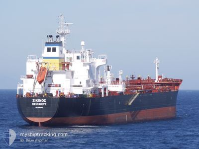
WONDER MIMOSA
Oil/Chemical Tanker
Current Trip
TANGER MED OPL
| Time Travelled | 3 days |
|---|---|
| Remaining Time | --- |
| Distance Travelled | 158.15 nm |
| Remaining Distance | --- |
| AVG Speed | 8.8 Noeuds |
| MAX Speed | 15.1 Noeuds |
| AVG Wind | 5.7 knots |
| MAX Wind | 11 knots |
| MIN Temp | 20.1°C / 68.18°F |
| MAX Temp | 23.3°C / 73.94°F |
| Tirant d eau | 7 m |
| Position reçue | Maintenant |
Current Position
| Longitude | -4.94640° |
|---|---|
| Latitude | 35.90225° |
| Etat | Under way using engine |
| Vitesse | 0.9 Noeuds |
| Parcours | 14° |
| Zone | Alboran Sea |
| Station | T-AIS |
| Position reçue | Maintenant |
Information
The current position of WONDER MIMOSA is in Alboran Sea with coordinates 35.90225° / -4.94640° as reported on 2025-06-09 14:23 by AIS to our vessel tracker app. The vessel's current speed is 0.9 Noeuds
The vessel WONDER MIMOSA (IMO: 9312901, MMSI: 538009459) is a Oil/Chemical Tanker that was built in 2006 ( 19 Age ). It's sailing under the flag of [MH] Marshall Is.
In this page you can find informations about the vessels current position, last detected port calls, and current voyage information. If the vessels is not in coverage by AIS you will find the latest position.
The current position of WONDER MIMOSA is detected by our AIS receivers and we are not responsible for the reliability of the data. The last position was recorded while the vessel was in Coverage by the Ais receivers of our vessel tracking app.
The current draught of WONDER MIMOSA as reported by AIS is 7 meters
Weather
| Temperature | 20.8°C / 69.44°F |
|---|---|
| Wind Speed | 11 knots |
| Direction | 42° NE |
| Pressure | 1019 hPa |
| Humidity | 92.2 % |
| Cloud Coverage | 100 % |
Featured Company
Last Port Calls
| Port | Arrival | Departure | Time In Port |
|---|---|---|---|
| 2025-06-04 13:05 | 2025-06-06 11:39 | 1 d | |
| 2025-05-25 15:21 | 2025-05-26 18:41 | 1 d | |
| 2025-05-13 10:47 | 2025-05-14 16:31 | 1 d | |
| 2025-05-05 23:44 | 2025-05-07 15:12 | 1 d | |
| 2025-04-23 20:21 | 2025-04-25 19:23 | 1 d | |
| 2025-04-12 03:30 | 2025-04-14 11:30 | 2 d | |
| 2025-04-01 03:09 |
Most Visited Ports (Last year)
| Port | Arrivals | |
|---|---|---|
| 5 | ||
| 3 | ||
| 2 | ||
| 2 | ||
| 2 | ||
| 2 |
Last Trips
| Origin | Departure | Destination | Arrival | Distance | |
|---|---|---|---|---|---|
| 2025-05-26 20:41 | 2025-06-04 14:05 | 1120.14 nm | |||
| 2025-05-14 16:31 | 2025-05-25 17:21 | 2802.70 nm | |||
| 2025-05-07 15:12 | 2025-05-13 10:47 | 534.98 nm | |||
| 2025-04-25 21:23 | 2025-05-05 23:44 | 2354.77 nm | |||
| 2025-04-14 13:30 | 2025-04-23 22:21 | 487.21 nm | |||
| 2025-04-01 05:09 | 2025-04-12 05:30 | 682.34 nm |
Events
| Heure | Evenement | Détails | Position/ Destination | Info |
|---|---|---|---|---|
| 2025-06-09 06:58 | Changement de zone | Spanish part of the Alboran Sea Moroccan part of the Alboran Sea |
35.80705 / -4.75140
Alboran Sea
|
Vitesse: 1 kn Parcours: 298° |
| 2025-06-09 06:54 | Etat Changé | Under way using engine Default |
35.80658 / -4.75038
TANGER MED OPL
|
Vitesse: 0.9 kn Parcours: 22° |
| 2025-06-09 06:49 | Etat Changé | Default Under way using engine |
35.80590 / -4.74872
TANGER MED OPL
|
Vitesse: 0.9 kn Parcours: 18° |
| 2025-06-09 06:27 | Etat Changé | Under way using engine Default |
35.80352 / -4.74307
TANGER MED OPL
|
Vitesse: 0.2 kn Parcours: 30° |
| 2025-06-09 06:20 | Arret |
35.80298 / -4.74270
TANGER MED OPL
|
Vitesse: 0.3 kn Parcours: 43° |
|
| 2025-06-09 06:17 | Etat Changé | Default Under way using engine |
35.80278 / -4.74302
TANGER MED OPL
|
Vitesse: 1 kn Parcours: 71° |
| 2025-06-09 06:09 | Etat Changé | Under way using engine Default |
35.80263 / -4.74530
TANGER MED OPL
|
Vitesse: 2.4 kn Parcours: 90° |
| 2025-06-09 06:01 | Etat Changé | Default Under way using engine |
35.80322 / -4.74993
TANGER MED OPL
|
Vitesse: 3 kn Parcours: 90° |
| 2025-06-09 05:50 | Etat Changé | Under way using engine Default |
35.80340 / -4.76427
TANGER MED OPL
|
Vitesse: 6.7 kn Parcours: 88° |
| 2025-06-09 05:13 | Etat Changé | Default Under way using engine |
35.79515 / -4.90163
TANGER MED OPL
|
Vitesse: 11.9 kn Parcours: 83° |