
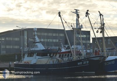
WR212 REIN WILLEM
Fishing
Current Trip
| Trip Time | 3 days |
|---|---|
| Trip Distance | 261.07 nm |
| AVG Speed | 4 Noeuds |
| MAX Speed | 9.8 Noeuds |
| Tirant d eau | 0 m |
| AVG Wind | 9.2 knots |
| MAX Wind | 22 knots |
| MIN Temp | 8.8°C / 47.84°F |
| MAX Temp | 10.6°C / 51.08°F |
| Position reçue | 1 m depuis |
Current Position
| Longitude | 5.03356° |
|---|---|
| Latitude | 52.93715° |
| Etat | Engaged in Fishing |
| Vitesse | |
| Parcours | 185° |
| Zone | North Sea |
| Station | T-AIS |
| Position reçue | 1 m depuis |
Information
The current position of WR212 REIN WILLEM is in North Sea with coordinates 52.93715° / 5.03356° as reported on 2025-04-27 07:42 by AIS to our vessel tracker app. The vessel's current speed is 0 Noeuds and is currently inside the port of DEN OEVER.
The vessel WR212 REIN WILLEM (IMO: 9853802, MMSI: 244170098) is a Fishing It's sailing under the flag of [NL] Netherlands.
In this page you can find informations about the vessels current position, last detected port calls, and current voyage information. If the vessels is not in coverage by AIS you will find the latest position.
The current position of WR212 REIN WILLEM is detected by our AIS receivers and we are not responsible for the reliability of the data. The last position was recorded while the vessel was in Coverage by the Ais receivers of our vessel tracking app.
Weather
| Temperature | 10.7°C / 51.26°F |
|---|---|
| Wind Speed | 8 knots |
| Direction | 128° SE |
| Pressure | 1025.1 hPa |
| Humidity | 79.9 % |
| Cloud Coverage | --- |
Featured Company
Last Port Calls
| Port | Arrival | Departure | Time In Port |
|---|---|---|---|
| 2025-04-24 06:10 | |||
| 2025-04-18 12:39 | 2025-04-21 04:56 | 2 d | |
| 2025-04-18 04:55 | 2025-04-18 12:07 | 7 h | |
| 2025-04-10 16:04 | 2025-04-13 21:54 | 3 d | |
| 2025-04-07 05:19 | 2025-04-07 06:18 | 59 m | |
| 2025-04-04 05:16 | 2025-04-06 22:03 | 2 d | |
| 2025-03-28 05:01 | 2025-03-30 22:02 | 2 d | |
| 2025-03-21 05:58 | 2025-03-23 23:03 | 2 d | |
| 2025-03-17 06:40 | 2025-03-17 08:32 | 1 h | |
| 2025-03-16 18:18 |
Most Visited Ports (Last year)
| Port | Arrivals | |
|---|---|---|
| 51 | ||
| 10 | ||
| 4 | ||
| 3 | ||
| 2 | ||
| 1 |
Last Trips
| Origin | Departure | Destination | Arrival | Distance | |
|---|---|---|---|---|---|
| 2025-04-21 06:56 | 2025-04-24 08:10 | 261.07 nm | |||
| 2025-04-18 14:07 | 2025-04-18 14:39 | 1.03 nm | |||
| 2025-04-13 23:54 | 2025-04-18 06:55 | 367.86 nm | |||
| 2025-04-07 08:18 | 2025-04-10 18:04 | 226.05 nm | |||
| 2025-04-07 00:03 | 2025-04-07 07:19 | 27.99 nm | |||
| 2025-03-31 00:02 | 2025-04-04 07:16 | 309.56 nm | |||
| 2025-03-24 00:03 | 2025-03-28 06:01 | 327.80 nm | |||
| 2025-03-17 09:32 | 2025-03-21 06:58 | 308.50 nm | |||
| 2025-03-16 19:18 | 2025-03-17 07:40 | 92.53 nm | |||
| 2025-02-16 23:40 | 2025-02-19 12:54 | 200.52 nm |
Events
| Heure | Evenement | Détails | Position/ Destination | Info |
|---|---|---|---|---|
| 2025-04-24 06:30 | Arret |
52.93596 / 5.03448
[NL] DEN OEVER
|
Vitesse: 0.3 kn Parcours: 136° |
|
| 2025-04-24 06:28 | Démarrage |
52.93616 / 5.03548
[NL] DEN OEVER
|
Vitesse: 6 kn Parcours: 283° |
|
| 2025-04-24 06:10 | Arret |
52.93444 / 5.03708
[NL] DEN OEVER
|
Vitesse: 0.3 kn Parcours: 228° |
|
| 2025-04-24 06:10 | Port d'arrivée |
|
52.93444 / 5.03708
[NL] DEN OEVER
|
Vitesse: 0.8 kn Parcours: 231° |
| 2025-04-24 06:05 | Démarrage | 0.19 nm, North East of DEN OEVER |
52.94033 / 5.03988
FISHING GROUND
|
Vitesse: 7.9 kn Parcours: 223.2° |
| 2025-04-24 03:45 | Arret | 0.32 nm, North East of DEN OEVER |
52.94188 / 5.04255
FISHING GROUND
|
Vitesse: 0.3 kn Parcours: 94° |
| 2025-04-23 18:54 | Dans la zone couverte |
53.09518 / 4.73641
North Sea
FISHING GROUND
|
Vitesse: 3.3 kn Parcours: 209.1° |
|
| 2025-04-23 15:25 | Hors de la zone couverte |
53.27306 / 4.88215
North Sea
FISHING GROUND
|
Vitesse: 9 kn Parcours: 221.8° |
|
| 2025-04-23 02:02 | Démarrage | 5.93 nm, West of AMELAND |
53.44802 / 5.58319
FISHING GROUND
|
Vitesse: 4.4 kn Parcours: 205° |
| 2025-04-23 01:46 | Arret | 5.95 nm, West of AMELAND |
53.44625 / 5.58215
FISHING GROUND
|
Vitesse: 0.3 kn Parcours: 223° |