

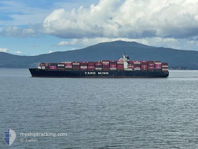
YM PLUM
Container Ship

Current Trip
| Trip Time | 2 days |
|---|---|
| Trip Distance | 161.67 nm |
| AVG Speed | 15.5 Noeuds |
| MAX Speed | 21.7 Noeuds |
| Tirant d eau | 12.5 m |
| AVG Wind | 11 knots |
| MAX Wind | 25.1 knots |
| MIN Temp | 9.5°C / 49.1°F |
| MAX Temp | 12.8°C / 55.04°F |
| Position reçue | Maintenant |
Current Position
| Longitude | -123.15250° |
|---|---|
| Latitude | 49.01817° |
| Etat | Moored |
| Vitesse | |
| Parcours | 212° |
| Zone | The Coastal Waters of Southeast Alaska and British Columbia |
| Station | T-AIS |
| Position reçue | Maintenant |
Information
The current position of YM PLUM is in The Coastal Waters of Southeast Alaska and British Columbia with coordinates 49.01817° / -123.15250° as reported on 2025-06-01 03:21 by AIS to our vessel tracker app. The vessel's current speed is 0 Noeuds and is currently inside the port of TSAWWASSEN.
The vessel YM PLUM (IMO: 9198264, MMSI: 636018262) is a Container Ship that was built in 2000 ( 25 Age ). It's sailing under the flag of [LR] Liberia.
In this page you can find informations about the vessels current position, last detected port calls, and current voyage information. If the vessels is not in coverage by AIS you will find the latest position.
The current position of YM PLUM is detected by our AIS receivers and we are not responsible for the reliability of the data. The last position was recorded while the vessel was in Coverage by the Ais receivers of our vessel tracking app.
The current draught of YM PLUM as reported by AIS is 12.5 meters
Weather
| Temperature | 15.6°C / 60.08°F |
|---|---|
| Wind Speed | 14 knots |
| Direction | 293° WNW |
| Pressure | 1019.6 hPa |
| Humidity | 62.7 % |
| Cloud Coverage | 7 % |


Featured Company
Last Port Calls
| Port | Arrival | Departure | Time In Port |
|---|---|---|---|
| 2025-05-31 12:45 | |||
| 2025-05-24 20:02 | 2025-05-29 04:31 | 4 d | |
| 2025-05-13 06:55 | 2025-05-13 18:51 | 11 h | |
| 2025-05-10 07:09 | 2025-05-10 16:07 | 8 h | |
| 2025-05-05 19:30 | 2025-05-06 12:38 | 17 h | |
| 2025-05-03 12:58 | 2025-05-04 05:04 | 16 h | |
| 2025-04-28 07:22 | 2025-04-28 20:35 | 13 h | |
| 2025-04-25 16:08 | 2025-04-26 13:23 | 21 h | |
| 2025-04-23 07:28 | 2025-04-24 16:56 | 1 d | |
| 2025-04-07 12:42 | 2025-04-09 08:39 | 1 d |
Most Visited Ports (Last year)
| Port | Arrivals | |
|---|---|---|
| 7 | ||
| 5 | ||
| 5 | ||
| 4 | ||
| 3 | ||
| 3 |
Last Trips
| Origin | Departure | Destination | Arrival | Distance | |
|---|---|---|---|---|---|
| 2025-05-29 04:31 | 2025-05-31 12:45 | 161.67 nm | |||
| 2025-05-13 18:51 | 2025-05-24 20:02 | 4346.54 nm | |||
| 2025-05-10 16:07 | 2025-05-13 06:55 | 237.32 nm | |||
| 2025-05-06 12:38 | 2025-05-10 07:09 | 918.25 nm | |||
| 2025-05-04 05:04 | 2025-05-05 19:30 | 531.95 nm | |||
| 2025-04-28 20:35 | 2025-05-03 12:58 | 1420.75 nm | |||
| 2025-04-26 13:23 | 2025-04-28 07:22 | 298.02 nm | |||
| 2025-04-24 16:56 | 2025-04-25 16:08 | 380.91 nm | |||
| 2025-04-09 08:39 | 2025-04-23 07:28 | 4317.99 nm | |||
| 2025-03-24 04:44 | 2025-04-07 12:42 | 595.88 nm |
Events
| Heure | Evenement | Détails | Position/ Destination | Info |
|---|---|---|---|---|
| 2025-06-01 03:15 | Etat Changé | Moored Default |
49.01817 / -123.15250
[CA] TSAWWASSEN
|
Vitesse: Parcours: 212° |
| 2025-06-01 03:03 | Etat Changé | Default Moored |
49.01817 / -123.15250
[CA] TSAWWASSEN
|
Vitesse: Parcours: 212° |
| 2025-06-01 02:39 | Etat Changé | Moored Default |
49.01817 / -123.15250
[CA] TSAWWASSEN
|
Vitesse: Parcours: 212° |
| 2025-06-01 02:36 | Etat Changé | Default Moored |
49.01817 / -123.15266
[CA] TSAWWASSEN
|
Vitesse: 0.5 kn Parcours: 212° |
| 2025-06-01 00:08 | Changement d'ETA | 2026/05/31 16:30 2025/05/31 16:30 |
49.01817 / -123.15250
[CA] TSAWWASSEN
|
Vitesse: Parcours: 212° |
| 2025-05-31 20:15 | Etat Changé | Moored Under way using engine |
49.01817 / -123.15250
[CA] TSAWWASSEN
|
Vitesse: Parcours: 212° |
| 2025-05-31 19:46 | Arret |
49.01433 / -123.15233
[CA] TSAWWASSEN
|
Vitesse: 0.2 kn Parcours: 44° |
|
| 2025-05-31 19:45 | Port d'arrivée |
|
49.01433 / -123.15233
[CA] TSAWWASSEN
|
Vitesse: 0.6 kn Parcours: 39° |
| 2025-05-31 19:29 | Changement de zone | Canadian part of the The Coastal Waters of Southeast Alaska and British Columbia United States part of the The Coastal Waters of Southeast Alaska and British Columbia |
49.00083 / -123.15617
The Coastal Waters of Southeast Alaska and British Columbia
CA VAN
|
Vitesse: 5.5 kn Parcours: 343° |
| 2025-05-31 18:43 | Changement de zone | United States part of the The Coastal Waters of Southeast Alaska and British Columbia Canadian part of the The Coastal Waters of Southeast Alaska and British Columbia |
48.85683 / -123.05467
The Coastal Waters of Southeast Alaska and British Columbia
CA VAN
|
Vitesse: 17.6 kn Parcours: 326° |