
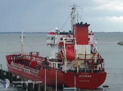
ZEUGMAN
Oil/Chemical Tanker
Current Trip
NOSLH
| Time Travelled | 1 day |
|---|---|
| Remaining Time | --- |
| Distance Travelled | 144.55 nm |
| Remaining Distance | --- |
| AVG Speed | 9.9 Noeuds |
| MAX Speed | 12.6 Noeuds |
| AVG Wind | 25.9 knots |
| MAX Wind | 43.4 knots |
| MIN Temp | -4.9°C / 23.18°F |
| MAX Temp | 4.9°C / 40.82°F |
| Tirant d eau | 6.4 m |
| Position reçue | 1 m depuis |
Current Position
| Longitude | 17.85338° |
|---|---|
| Latitude | 69.15396° |
| Etat | Under way using engine |
| Vitesse | 8.8 Noeuds |
| Parcours | 246° |
| Zone | Norwegian Sea |
| Station | T-AIS |
| Position reçue | 1 m depuis |
Info
Information
The current position of ZEUGMAN is in Norwegian Sea with coordinates 69.15396° / 17.85338° as reported on 2025-02-07 06:58 by AIS to our vessel tracker app. The vessel's current speed is 8.8 Noeuds
The vessel ZEUGMAN (IMO: 9259111, MMSI: 215382000) is a Oil/Chemical Tanker that was built in 2003 ( 22 Age ). It's sailing under the flag of [MT] Malta.
In this page you can find informations about the vessels current position, last detected port calls, and current voyage information. If the vessels is not in coverage by AIS you will find the latest position.
The current position of ZEUGMAN is detected by our AIS receivers and we are not responsible for the reliability of the data. The last position was recorded while the vessel was in Coverage by the Ais receivers of our vessel tracking app.
The current draught of ZEUGMAN as reported by AIS is 6.4 meters
Weather
| Temperature | 3.3°C / 37.94°F |
|---|---|
| Wind Speed | 32 knots |
| Direction | 230° SW |
| Pressure | 1027.8 hPa |
| Humidity | 99.2 % |
| Cloud Coverage | 100 % |
Featured Company
Last Port Calls
| Port | Arrival | Departure | Time In Port |
|---|---|---|---|
| 2025-02-04 22:55 | 2025-02-05 15:59 | 17 h | |
| 2025-02-03 04:56 | 2025-02-03 15:19 | 10 h | |
| 2025-01-31 11:38 | 2025-01-31 21:27 | 9 h | |
| 2025-01-30 23:20 | 2025-01-31 04:55 | 5 h | |
| 2025-01-23 23:54 | 2025-01-25 22:36 | 1 d | |
| 2025-01-21 14:08 | 2025-01-22 16:45 | 1 d | |
| 2025-01-19 19:42 | 2025-01-19 20:32 | 49 m | |
| 2025-01-16 19:05 | 2025-01-17 20:49 | 1 d | |
| 2025-01-14 13:31 | 2025-01-15 07:26 | 17 h | |
| 2025-01-11 16:03 | 2025-01-12 08:40 | 16 h |
Last Trips
| Origin | Departure | Destination | Arrival | Distance | |
|---|---|---|---|---|---|
| 2025-02-03 16:19 | 2025-02-04 23:55 | 200.78 nm | |||
| 2025-01-31 22:27 | 2025-02-03 05:56 | 454.33 nm | |||
| 2025-01-31 05:55 | 2025-01-31 12:38 | 73.13 nm | |||
| 2025-01-25 23:36 | 2025-01-31 00:20 | 900.67 nm | |||
| 2025-01-22 17:45 | 2025-01-24 00:54 | 80.06 nm | |||
| 2025-01-19 21:32 | 2025-01-21 15:08 | 497.54 nm | |||
| 2025-01-17 22:49 | 2025-01-19 20:42 | 450.53 nm | |||
| 2025-01-15 08:26 | 2025-01-16 21:05 | 181.19 nm | |||
| 2025-01-12 09:40 | 2025-01-14 14:31 | 545.25 nm | |||
| 2025-01-10 23:09 | 2025-01-11 17:03 | 24.93 nm |
Events
| Heure | Evenement | Détails | Position/ Destination | Info |
|---|---|---|---|---|
| 2025-02-07 01:45 | Tirant d'eau modifié | 6.4 6 |
69.60582 / 18.88397
NOSLH
|
Vitesse: 8.9 kn Parcours: 215.5° |
| 2025-02-07 01:45 | Changement d'ETA | 2025/02/10 15:00 |
69.60582 / 18.88397
NOSLH
|
Vitesse: 8.9 kn Parcours: 215.5° |
| 2025-02-07 01:39 | Tirant d'eau modifié | 6 6.4 |
69.61823 / 18.90880
NOSLH
|
Vitesse: 9.3 kn Parcours: 220.4° |
| 2025-02-07 00:45 | Tirant d'eau modifié | 6.4 6 |
69.73197 / 19.04748
NOSLH
|
Vitesse: 8.2 kn Parcours: 183° |
| 2025-02-07 00:45 | Changement d'ETA | 2025/02/10 15:00 |
69.73197 / 19.04748
NOSLH
|
Vitesse: 8.2 kn Parcours: 183° |
| 2025-02-07 00:33 | Tirant d'eau modifié | 6 6.4 |
69.75545 / 19.08083
NOSLH
|
Vitesse: 8 kn Parcours: 219° |
| 2025-02-06 23:57 | Tirant d'eau modifié | 6.4 6 |
69.79017 / 19.29056
NOSLH
|
Vitesse: 7.9 kn Parcours: 253° |
| 2025-02-06 23:57 | Changement d'ETA | 2025/02/10 15:00 |
69.79017 / 19.29056
NOSLH
|
Vitesse: 7.9 kn Parcours: 253° |
| 2025-02-06 23:45 | Tirant d'eau modifié | 6 6.4 |
69.79915 / 19.36561
NOSLH
|
Vitesse: 7.9 kn Parcours: 251° |
| 2025-02-06 21:29 | Démarrage | 17.74 nm, East of TROMSO |
69.61185 / 19.80899
NOSLH
|
Vitesse: 5.5 kn Parcours: 341.4° |