
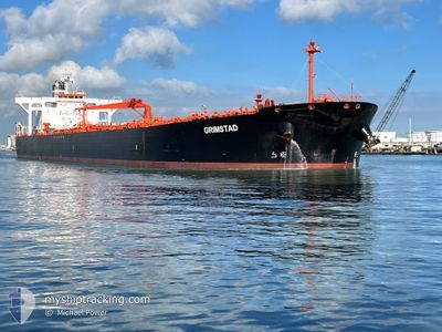
GRIMSTAD
Crude Oil Tanker
Current Trip
| Time Travelled | 30 days |
|---|---|
| Remaining Time | 17 mins |
| Distance Travelled | 3420.96 морская миля |
| Remaining Distance | 6.59 морская миля |
| AVG Speed | 10 Узлы |
| MAX Speed | 15 Узлы |
| AVG Wind | 15.1 knots |
| MAX Wind | 29 knots |
| MIN Temp | 1.1°C / 33.98°F |
| MAX Temp | 19.5°C / 67.1°F |
| Осадка | 12.3 м |
| Позиция Получена | 2 m тому назад |
Current Position
| Долгота | -1.30928° |
|---|---|
| Широта | 50.79198° |
| Статус | Under way using engine |
| Скорость | 9.4 Узлы |
| Курс | 35.6° |
| Район | English Channel |
| Станция | T-AIS |
| Позиция Получена | 2 m тому назад |
Info
Information
The current position of GRIMSTAD is in English Channel with coordinates 50.79198° / -1.30928° as reported on 2026-01-04 10:25 by AIS to our vessel tracker app. The vessel's current speed is 9.4 Узлы and is heading at the port of FAWLEY. The estimated time of arrival as calculated by MyShipTracking vessel tracking app is 2026-01-04 10:44 LT
The vessel GRIMSTAD (IMO: 9336402, MMSI: 309518000) is a Crude Oil Tanker that was built in 2007 ( 19 лет ). It's sailing under the flag of [BS] Bahamas.
In this page you can find informations about the vessels current position, last detected port calls, and current voyage information. If the vessels is not in coverage by AIS you will find the latest position.
The current position of GRIMSTAD is detected by our AIS receivers and we are not responsible for the reliability of the data. The last position was recorded while the vessel was in Coverage by the Ais receivers of our vessel tracking app.
The current draught of GRIMSTAD as reported by AIS is 12.3 meters
Weather
| Temperature | 1.5°C / 34.7°F |
|---|---|
| Wind Speed | 7 knots |
| Direction | 298° WNW |
| Pressure | 1015.9 hPa |
| Humidity | 71.2 % |
| Cloud Coverage | 14 % |
Featured Company
Events
| Время | Событие | Детали | Позиция / Направление | Информация |
|---|---|---|---|---|
| 2026-01-04 07:42 | Начало движения | 5.9 nm, South East of SANDOWN |
50.58418 / -1.03984
GBFAW
|
Скорость: 3.1 kn Курс: 193° |
| 2026-01-04 07:06 | Статус изменился | Under way using engine At anchor |
50.59804 / -1.04446
GBFAW
|
Скорость: Курс: 263° |
| 2026-01-04 06:48 | ETA изменился | 2026/01/04 09:00 2026/12/29 07:00 |
50.59900 / -1.04464
GBFAW
|
Скорость: 0.2 kn Курс: 253° |
| 2026-01-02 07:03 | Статус изменился | At anchor Default |
50.59911 / -1.04315
GBFAW
|
Скорость: 0.1 kn Курс: 246° |
| 2026-01-02 07:00 | Статус изменился | Default At anchor |
50.59927 / -1.04334
GBFAW
|
Скорость: 0.3 kn Курс: 254° |
| 2026-01-01 10:03 | Статус изменился | At anchor Default |
50.59758 / -1.05215
GBFAW
|
Скорость: Курс: 48° |
| 2026-01-01 10:00 | Статус изменился | Default At anchor |
50.59759 / -1.05208
GBFAW
|
Скорость: Курс: 48° |
| 2026-01-01 00:03 | ETA изменился | 2026/12/29 07:00 2025/12/29 07:00 |
50.59761 / -1.05079
GBFAW
|
Скорость: Курс: 52° |
| 2025-12-31 00:03 | Статус изменился | At anchor Default |
50.59691 / -1.05141
GBFAW
|
Скорость: Курс: 55° |
| 2025-12-31 00:00 | Статус изменился | Default At anchor |
50.59692 / -1.05139
GBFAW
|
Скорость: Курс: 55° |