
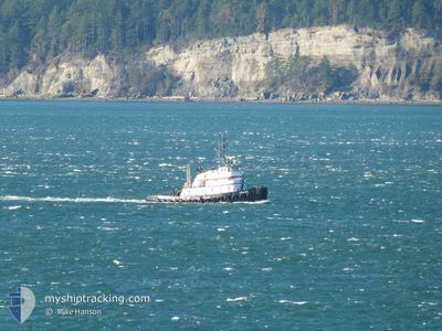
LELA JOY
Tug
Current Trip
| Time Travelled | 7 h, 17 mins |
|---|---|
| Remaining Time | 19 h, 11 mins |
| Distance Travelled | 53.64 морская миля |
| Remaining Distance | 70.19 морская миля |
| AVG Speed | 7.1 Узлы |
| MAX Speed | 10.5 Узлы |
| AVG Wind | 8 knots |
| MAX Wind | 10.7 knots |
| MIN Temp | 1.6°C / 34.88°F |
| MAX Temp | 4°C / 39.2°F |
| Осадка | 3.5 м |
| Позиция Получена | Сейчас |
Current Position
| Долгота | -122.73265° |
|---|---|
| Широта | 48.39512° |
| Статус | Under way using engine |
| Скорость | 4.7 Узлы |
| Курс | 6° |
| Район | The Coastal Waters of Southeast Alaska and British Columbia |
| Станция | T-AIS |
| Позиция Получена | Сейчас |
Info
Information
The current position of LELA JOY is in The Coastal Waters of Southeast Alaska and British Columbia with coordinates 48.39512° / -122.73265° as reported on 2025-02-08 01:52 by AIS to our vessel tracker app. The vessel's current speed is 4.7 Узлы and is heading at the port of VANCOUVER. The estimated time of arrival as calculated by MyShipTracking vessel tracking app is 2025-02-08 21:04 LT
The vessel LELA JOY (IMO: 7316460, MMSI: 366980230) is a Tug that was built in 1970 ( 55 лет ). It's sailing under the flag of [US] USA.
In this page you can find informations about the vessels current position, last detected port calls, and current voyage information. If the vessels is not in coverage by AIS you will find the latest position.
The current position of LELA JOY is detected by our AIS receivers and we are not responsible for the reliability of the data. The last position was recorded while the vessel was in Coverage by the Ais receivers of our vessel tracking app.
The current draught of LELA JOY as reported by AIS is 3.5 meters
Weather
| Temperature | 3.5°C / 38.3°F |
|---|---|
| Wind Speed | 10 knots |
| Direction | 140° SE |
| Pressure | 1022.6 hPa |
| Humidity | 68 % |
| Cloud Coverage | 100 % |
Featured Company
Last Port Calls
| Port | Arrival | Departure | Time In Port |
|---|---|---|---|
| 2025-02-06 20:39 | 2025-02-07 18:36 | 21 h | |
| 2025-02-04 16:19 | 2025-02-06 17:12 | 2 d | |
| 2025-02-01 20:11 | 2025-02-04 15:36 | 2 d | |
| 2025-01-31 22:16 | 2025-02-01 19:47 | 21 h | |
| 2025-01-17 00:37 | 2025-01-31 20:12 | 14 d | |
| 2025-01-16 18:46 | 2025-01-16 22:27 | 3 h | |
| 2025-01-13 15:38 | 2025-01-16 16:11 | 3 d | |
| 2025-01-13 13:39 | 2025-01-13 15:07 | 1 h | |
| 2024-12-28 01:52 | 2025-01-13 13:22 | 16 d | |
| 2024-12-10 10:38 | 2024-12-28 01:29 | 17 d |
Last Trips
| Origin | Departure | Destination | Arrival | Distance | |
|---|---|---|---|---|---|
| 2025-02-06 09:12 | 2025-02-06 12:39 | 25.28 морская миля | |||
| 2025-02-04 07:36 | 2025-02-04 08:19 | 1.24 морская миля | |||
| 2025-02-01 11:47 | 2025-02-01 12:11 | 1.75 морская миля | |||
| 2025-01-31 12:12 | 2025-01-31 14:16 | 16.86 морская миля | |||
| 2025-01-16 14:27 | 2025-01-16 16:37 | 21.77 морская миля | |||
| 2025-01-16 08:11 | 2025-01-16 10:46 | 25.07 морская миля | |||
| 2025-01-13 07:07 | 2025-01-13 07:38 | 1.40 морская миля | |||
| 2025-01-13 05:22 | 2025-01-13 05:39 | 1.33 морская миля | |||
| 2024-12-27 17:29 | 2024-12-27 17:52 | 1.34 морская миля | |||
| 2024-12-10 01:54 | 2024-12-10 02:38 | 1.57 морская миля |
Events
| Время | Событие | Детали | Позиция / Направление | Информация |
|---|---|---|---|---|
| 2025-02-07 21:10 | Статус изменился | Under way using engine Default |
47.93010 / -122.48162
VAN
|
Скорость: 8.9 kn Курс: 348° |
| 2025-02-07 21:07 | Статус изменился | Default Under way using engine |
47.92408 / -122.47925
VAN
|
Скорость: 8.6 kn Курс: 347.2° |
| 2025-02-07 20:41 | Осадка изменилась | 3.5 3 |
47.86300 / -122.46009
VAN
|
Скорость: 8.1 kn Курс: 348.8° |
| 2025-02-07 20:41 | ETA изменился | 2025/02/08 01:00 |
47.86300 / -122.46009
VAN
|
Скорость: 8.1 kn Курс: 348.8° |
| 2025-02-07 20:25 | Начало движения | 2.46 nm, North West of EDMONDS |
47.82840 / -122.44603
VAN
|
Скорость: 7.8 kn Курс: 343° |
| 2025-02-07 20:23 | Окончание движения | 2.32 nm, West of EDMONDS |
47.82492 / -122.44438
VAN
|
Скорость: Курс: 340° |
| 2025-02-07 20:04 | Начало движения | 1.35 nm, West of POINT WELLS |
47.78406 / -122.43204
VAN
|
Скорость: 7.8 kn Курс: 352° |
| 2025-02-07 20:03 | Окончание движения | 1.32 nm, West of POINT WELLS |
47.78192 / -122.43153
VAN
|
Скорость: Курс: 349° |
| 2025-02-07 19:53 | Начало движения | 1.73 nm, South West of POINT WELLS |
47.76046 / -122.42791
VAN
|
Скорость: 7.6 kn Курс: 5° |
| 2025-02-07 19:52 | Окончание движения | 1.83 nm, South West of POINT WELLS |
47.75832 / -122.42823
VAN
|
Скорость: Курс: 5° |