

LIGRUNN 2
Fishing

Current Trip
CH 16
| Time Travelled | 28 days |
|---|---|
| Remaining Time | --- |
| Distance Travelled | 693.88 морская миля |
| Remaining Distance | --- |
| AVG Speed | 9.4 Узлы |
| MAX Speed | 12.9 Узлы |
| AVG Wind | 11.8 knots |
| MAX Wind | 31.9 knots |
| MIN Temp | 6.3°C / 43.34°F |
| MAX Temp | 13.7°C / 56.66°F |
| Осадка | 7.5 м |
| Позиция Получена | 18 h, 24 m тому назад |
Current Position
| Долгота | 2.50873° |
|---|---|
| Широта | 60.12157° |
| Статус | Under way using engine |
| Скорость | 10.6 Узлы |
| Курс | 267.5° |
| Район | North Sea |
| Станция | T-AIS |
| Позиция Получена | 18 h, 24 m тому назад |
Information
The current position of LIGRUNN 2 is in North Sea with coordinates 60.12157° / 2.50873° as reported on 2025-06-05 03:43 by AIS to our vessel tracker app. The vessel's current speed is 10.6 Узлы
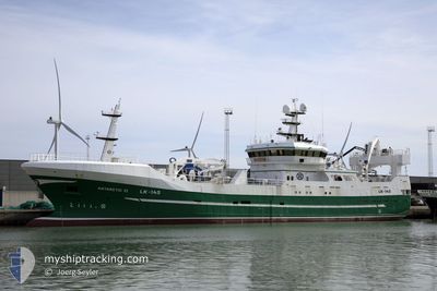
The vessel LIGRUNN 2 (IMO: 9287508, MMSI: 257442000) is a Fishing It's sailing under the flag of [NO] Norway.
In this page you can find informations about the vessels current position, last detected port calls, and current voyage information. If the vessels is not in coverage by AIS you will find the latest position.
The current position of LIGRUNN 2 is detected by our AIS receivers and we are not responsible for the reliability of the data. The last position was recorded while the vessel was in Coverage by the Ais receivers of our vessel tracking app.
The current draught of LIGRUNN 2 as reported by AIS is 7.5 meters
Weather
| Temperature | 10.6°C / 51.08°F |
|---|---|
| Wind Speed | 17 knots |
| Direction | 202° SSW |
| Pressure | 993.8 hPa |
| Humidity | 78.7 % |
| Cloud Coverage | 95 % |


Featured Company
Most Visited Ports (Last year)
| Port | Arrivals | |
|---|---|---|
| 3 | ||
| 3 | ||
| 2 | ||
| 2 | ||
| 1 | ||
| 1 |
Events
| Время | Событие | Детали | Позиция / Направление | Информация |
|---|---|---|---|---|
| 2025-06-05 03:43 | Вне покрытия |
60.12157 / 2.50873
North Sea
|
Скорость: 10.6 kn Курс: 267.5° |
|
| 2025-06-04 18:29 | Начало движения | 0.51 nm, South of KLEPPESTO |
60.39786 / 5.23360
CH 16
|
Скорость: 4.4 kn Курс: 259° |
| 2025-06-04 16:53 | Окончание движения | 0.62 nm, South of KLEPPESTO |
60.39607 / 5.23476
CH 16
|
Скорость: 0.3 kn Курс: 173° |
| 2025-06-04 16:10 | Начало движения | 4.15 nm, South of KNARREVIK |
60.30364 / 5.13553
CH 16
|
Скорость: 4.4 kn Курс: 38° |
| 2025-06-02 18:43 | Окончание движения | 4.22 nm, North West of HJELLESTAD |
60.30206 / 5.13352
CH 16
|
Скорость: 0.3 kn Курс: 206° |
| 2025-06-02 14:33 | Изменение морского района | Norwegian part of the North Sea Norwegian part of the Norwegian Sea |
60.99741 / 4.75688
North Sea
|
Скорость: 10.7 kn Курс: 179.8° |
| 2025-06-02 10:51 | Начало движения | 1.7 nm, South West of FLORO |
61.58773 / 4.97880
CH 16
|
Скорость: 10.9 kn Курс: 289.6° |
| 2025-06-02 04:32 | Окончание движения | 1.35 nm, South West of FLORO |
61.58542 / 4.99847
CH 16
|
Скорость: 0.2 kn Курс: 306° |
| 2025-06-01 23:46 | Изменение морского района | Norwegian part of the Norwegian Sea Norwegian part of the North Sea |
61.00727 / 3.65345
Norwegian Sea
|
Скорость: 11.8 kn Курс: 35.5° |
| 2025-06-01 17:59 | В покрытии |
60.62117 / 2.63301
North Sea
|
Скорость: 4.7 kn Курс: 320.7° |