
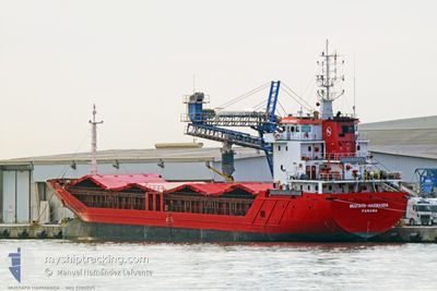
MUSTAFA HARMANDA
General Cargo
Current Trip
| Time Travelled | 5 days |
|---|---|
| Remaining Time | --- |
| Distance Travelled | 933.53 морская миля |
| Remaining Distance | --- |
| AVG Speed | 7.3 Узлы |
| MAX Speed | 10 Узлы |
| AVG Wind | 12.6 knots |
| MAX Wind | 25.3 knots |
| MIN Temp | 8°C / 46.4°F |
| MAX Temp | 18.9°C / 66.02°F |
| Осадка | 6.2 м |
| Позиция Получена | 19 h, 54 m тому назад |
Current Position
| Долгота | 18.92468° |
|---|---|
| Широта | 36.68738° |
| Статус | Under way using engine |
| Скорость | 7.1 Узлы |
| Курс | 96.6° |
| Район | Ionian Sea |
| Станция | T-AIS |
| Позиция Получена | 19 h, 54 m тому назад |
Info
Information
The current position of MUSTAFA HARMANDA is in Ionian Sea with coordinates 36.68738° / 18.92468° as reported on 2026-01-06 19:37 by AIS to our vessel tracker app. The vessel's current speed is 7.1 Узлы and is heading at the port of GEMLIK. The estimated time of arrival as calculated by MyShipTracking vessel tracking app is 2026-01-10 11:00 LT
The vessel MUSTAFA HARMANDA (IMO: 9280225, MMSI: 371020000) is a General Cargo that was built in 2003 ( 23 лет ). It's sailing under the flag of [PA] Panama.
In this page you can find informations about the vessels current position, last detected port calls, and current voyage information. If the vessels is not in coverage by AIS you will find the latest position.
The current position of MUSTAFA HARMANDA is detected by our AIS receivers and we are not responsible for the reliability of the data. The last position was recorded while the vessel was in Coverage by the Ais receivers of our vessel tracking app.
The current draught of MUSTAFA HARMANDA as reported by AIS is 6.2 meters
Weather
| Temperature | 18.7°C / 65.66°F |
|---|---|
| Wind Speed | 18 knots |
| Direction | 195° SSW |
| Pressure | 1010.6 hPa |
| Humidity | 75.9 % |
| Cloud Coverage | 100 % |
Featured Company
Last Port Calls
| Port | Arrival | Departure | Time In Port |
|---|---|---|---|
| 2025-12-29 12:37 | 2026-01-02 13:56 | 4 d | |
| 2025-12-23 08:13 | 2025-12-24 13:15 | 1 d | |
| 2025-12-18 00:38 | 2025-12-18 23:22 | 22 h | |
| 2025-12-14 11:12 | 2025-12-16 17:59 | 2 d | |
| 2025-12-06 11:37 | 2025-12-09 08:05 | 2 d | |
| 2025-11-30 09:36 | 2025-12-03 19:02 | 3 d | |
| 2025-11-23 07:40 | 2025-11-25 16:12 | 2 d | |
| 2025-11-13 08:31 | 2025-11-19 08:45 | 6 d | |
| 2025-11-06 14:50 | 2025-11-08 11:42 | 1 d | |
| 2025-11-03 02:26 | 2025-11-04 18:11 | 1 d |
Last Trips
| Origin | Departure | Destination | Arrival | Distance | |
|---|---|---|---|---|---|
| 2025-12-24 13:15 | 2025-12-29 12:37 | 676.19 морская миля | |||
| 2025-12-18 23:22 | 2025-12-23 08:13 | 646.99 морская миля | |||
| 2025-12-16 17:59 | 2025-12-18 00:38 | 237.99 морская миля | |||
| 2025-12-09 08:05 | 2025-12-14 11:12 | 244.50 морская миля | |||
| 2025-12-03 19:02 | 2025-12-06 11:37 | 205.36 морская миля | |||
| 2025-11-25 16:12 | 2025-11-30 09:36 | 230.13 морская миля | |||
| 2025-11-19 08:45 | 2025-11-23 07:40 | 230.75 морская миля | |||
| 2025-11-08 11:42 | 2025-11-13 08:31 | 912.61 морская миля | |||
| 2025-11-04 18:11 | 2025-11-06 14:50 | 319.67 морская миля | |||
| 2025-10-27 07:37 | 2025-11-03 02:26 | 920.34 морская миля |
Events
| Время | Событие | Детали | Позиция / Направление | Информация |
|---|---|---|---|---|
| 2026-01-06 19:46 | Статус изменился | Default Under way using engine |
36.68336 / 18.94580
TRGEM
|
Скорость: 7.1 kn Курс: 96.6° |
| 2026-01-06 19:37 | Статус изменился | Under way using engine Default |
36.68738 / 18.92468
TRGEM
|
Скорость: 7.4 kn Курс: 90° |
| 2026-01-06 19:37 | Вне покрытия |
36.68738 / 18.92468
Ionian Sea
TRGEM
|
Скорость: 7.1 kn Курс: 96.6° |
|
| 2026-01-06 19:28 | В покрытии |
36.68738 / 18.92468
Ionian Sea
TRGEM
|
Скорость: 7.1 kn Курс: 96.6° |
|
| 2026-01-06 17:09 | Статус изменился | Default Under way using engine |
36.78969 / 18.58368
TRGEM
|
Скорость: 7.9 kn Курс: 119.9° |
| 2026-01-06 17:00 | Статус изменился | Under way using engine Default |
36.79608 / 18.56359
TRGEM
|
Скорость: 7.6 kn Курс: 114° |
| 2026-01-06 17:00 | Вне покрытия |
36.79608 / 18.56359
Ionian Sea
TRGEM
|
Скорость: 7.9 kn Курс: 119.9° |
|
| 2026-01-06 16:41 | Статус изменился | Default Under way using engine |
36.81095 / 18.51633
TRGEM
|
Скорость: 7.3 kn Курс: 105.1° |
| 2026-01-06 16:33 | Обнаружено в море | Greek part of the Ionian Sea |
36.81687 / 18.49815
Ionian Sea
TRGEM
|
Скорость: 7.3 kn Курс: 105.1° |
| 2026-01-06 16:33 | Статус изменился | Under way using engine Default |
36.81687 / 18.49815
TRGEM
|
Скорость: 7.8 kn Курс: 127° |