
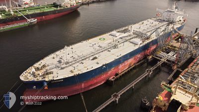
SEACHARM
Tanker
Current Trip
| Time Travelled | 11 days |
|---|---|
| Remaining Time | --- |
| Distance Travelled | 810.47 морская миля |
| Remaining Distance | --- |
| AVG Speed | 6.5 Узлы |
| MAX Speed | 14.5 Узлы |
| AVG Wind | 18.1 knots |
| MAX Wind | 36 knots |
| MIN Temp | 8°C / 46.4°F |
| MAX Temp | 16°C / 60.8°F |
| Осадка | 8.2 м |
| Позиция Получена | 3 d тому назад |
Current Position
| Долгота | 23.66436° |
|---|---|
| Широта | 36.62521° |
| Статус | Under way using engine |
| Скорость | 11.2 Узлы |
| Курс | 190.2° |
| Район | Aegean Sea |
| Станция | T-AIS |
| Позиция Получена | 3 d тому назад |
Info
Information
The current position of SEACHARM is in Aegean Sea with coordinates 36.62521° / 23.66436° as reported on 2025-02-07 18:17 by AIS to our vessel tracker app. The vessel's current speed is 11.2 Узлы and is heading at the port of ES SIDER. The estimated time of arrival as calculated by MyShipTracking vessel tracking app is 2025-02-09 18:00 LT
The vessel SEACHARM (IMO: 9773765, MMSI: 538007825) is a Tanker It's sailing under the flag of [MH] Marshall Is.
In this page you can find informations about the vessels current position, last detected port calls, and current voyage information. If the vessels is not in coverage by AIS you will find the latest position.
The current position of SEACHARM is detected by our AIS receivers and we are not responsible for the reliability of the data. The last position was recorded while the vessel was in Coverage by the Ais receivers of our vessel tracking app.
The current draught of SEACHARM as reported by AIS is 8.2 meters
Weather
| Temperature | 15.8°C / 60.44°F |
|---|---|
| Wind Speed | 6 knots |
| Direction | 110° ESE |
| Pressure | 1023.3 hPa |
| Humidity | 57.2 % |
| Cloud Coverage | 27 % |
Featured Company
Last Port Calls
| Port | Arrival | Departure | Time In Port |
|---|---|---|---|
| 2025-01-20 15:58 | 2025-01-30 15:00 | 9 d | |
| 2025-01-06 21:28 | 2025-01-08 11:52 | 1 d | |
| 2024-12-28 01:25 | 2024-12-28 23:32 | 22 h | |
| 2024-12-24 13:49 | 2024-12-25 11:48 | 21 h | |
| 2024-12-18 23:13 | 2024-12-19 17:44 | 18 h | |
| 2024-12-11 08:24 | 2024-12-14 19:09 | 3 d |
Last Trips
| Origin | Departure | Destination | Arrival | Distance | |
|---|---|---|---|---|---|
| 2025-01-08 11:52 | 2025-01-20 15:58 | 2531.75 морская миля | |||
| 2024-12-28 23:32 | 2025-01-06 21:28 | 1223.71 морская миля | |||
| 2024-12-25 11:48 | 2024-12-28 01:25 | 645.71 морская миля | |||
| 2024-12-19 17:44 | 2024-12-24 13:49 | 1384.27 морская миля | |||
| 2024-12-14 19:09 | 2024-12-18 23:13 | 830.26 морская миля | |||
| 2024-11-21 21:58 | 2024-12-11 08:24 | 1600.02 морская миля |
Events
| Время | Событие | Детали | Позиция / Направление | Информация |
|---|---|---|---|---|
| 2025-02-10 14:58 | Окончание движения | 3.14 nm, North East of ES SIDER |
30.66518 / 18.41865
LYESI
|
Скорость: 0.3 kn Курс: 117° |
| 2025-02-10 12:37 | Начало движения | 3.26 nm, North of ES SIDER |
30.68686 / 18.39048
LYESI
|
Скорость: 4.1 kn Курс: 167° |
| 2025-02-09 16:33 | Окончание движения | 4.1 nm, North of ES SIDER |
30.70225 / 18.38852
LYESI
|
Скорость: 0.1 kn Курс: 81° |
| 2025-02-07 18:25 | Статус изменился | Default Under way using engine |
36.59862 / 23.65808
LYESI
|
Скорость: 11.2 kn Курс: 190.2° |
| 2025-02-07 18:17 | Вне покрытия |
36.62521 / 23.66436
Aegean Sea
LYESI
|
Скорость: 11.2 kn Курс: 190.2° |
|
| 2025-02-07 18:03 | Статус изменился | Under way using engine Default |
36.66712 / 23.67310
LYESI
|
Скорость: 11 kn Курс: 188° |
| 2025-02-07 17:58 | Статус изменился | Default Under way using engine |
36.68322 / 23.67649
LYESI
|
Скорость: 10.9 kn Курс: 190.3° |
| 2025-02-07 16:31 | Пункт назначения изменился | LYESI GRPIR |
36.94410 / 23.72543
LYESI
|
Скорость: 11.1 kn Курс: 191.1° |
| 2025-02-07 16:31 | ETA изменился | 2025/02/09 16:00 2026/01/31 08:00 |
36.94410 / 23.72543
LYESI
|
Скорость: 11.1 kn Курс: 191.1° |
| 2025-02-07 15:07 | Статус изменился | Under way using engine Default |
37.18426 / 23.74688
GRPIR
|
Скорость: 2.1 kn Курс: 122° |