
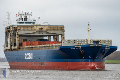
STAR ISTIND
General Cargo
Current Trip
USMOB
| Time Travelled | 4 days |
|---|---|
| Remaining Time | --- |
| Distance Travelled | 1343.56 морская миля |
| Remaining Distance | --- |
| AVG Speed | 13.3 Узлы |
| MAX Speed | 15.8 Узлы |
| AVG Wind | 10.6 knots |
| MAX Wind | 16 knots |
| MIN Temp | 15.3°C / 59.54°F |
| MAX Temp | 25.9°C / 78.62°F |
| Осадка | 11 м |
| Позиция Получена | 5 h, 11 m тому назад |
Current Position
| Долгота | -71.05040° |
|---|---|
| Широта | 20.11398° |
| Статус | Under way using engine |
| Скорость | 12.7 Узлы |
| Курс | 103.7° |
| Район | North Atlantic Ocean |
| Станция | T-AIS |
| Позиция Получена | 5 h, 11 m тому назад |
Info
Information
The current position of STAR ISTIND is in North Atlantic Ocean with coordinates 20.11398° / -71.05040° as reported on 2025-03-14 18:14 by AIS to our vessel tracker app. The vessel's current speed is 12.7 Узлы
The vessel STAR ISTIND (IMO: 9182954, MMSI: 257424000) is a General Cargo that was built in 1999 ( 26 лет ). It's sailing under the flag of [NO] Norway.
In this page you can find informations about the vessels current position, last detected port calls, and current voyage information. If the vessels is not in coverage by AIS you will find the latest position.
The current position of STAR ISTIND is detected by our AIS receivers and we are not responsible for the reliability of the data. The last position was recorded while the vessel was in Coverage by the Ais receivers of our vessel tracking app.
The current draught of STAR ISTIND as reported by AIS is 11 meters
Weather
| Temperature | 25.5°C / 77.9°F |
|---|---|
| Wind Speed | 9 knots |
| Direction | 74° ENE |
| Pressure | 1013.1 hPa |
| Humidity | 69.4 % |
| Cloud Coverage | 4 % |
Featured Company
Events
| Время | Событие | Детали | Позиция / Направление | Информация |
|---|---|---|---|---|
| 2025-03-14 18:49 | Статус изменился | Default Under way using engine |
20.08464 / -70.92020
USMOB
|
Скорость: 12.7 kn Курс: 103.7° |
| 2025-03-14 18:14 | Вне покрытия |
20.11398 / -71.05040
North Atlantic Ocean
|
Скорость: 12.7 kn Курс: 103.7° |
|
| 2025-03-14 16:52 | Изменение морского района | Dominican Republic part of the North Atlantic Ocean United States part of the Gulf of Mexico |
20.18331 / -71.36493
North Atlantic Ocean
|
Скорость: 13.7 kn Курс: 101.4° |
| 2025-03-14 16:50 | В покрытии |
20.18331 / -71.36493
North Atlantic Ocean
|
Скорость: 13.7 kn Курс: 101.4° |
|
| 2025-03-10 17:55 | ПОРТ ОТПРАВЛЕНИЯ |
|
30.61743 / -88.03271
USMOB
|
Скорость: 11.1 kn Курс: 183° |
| 2025-03-10 17:08 | Начало движения |
30.70567 / -88.03812
[US] MOBILE
|
Скорость: 4.7 kn Курс: 172° |
|
| 2025-03-08 09:44 | Осадка изменилась | 11 10.8 |
30.71044 / -88.04196
[US] MOBILE
|
Скорость: Курс: 300° |
| 2025-03-08 09:44 | ETA изменился | 2025/03/07 05:00 2025/03/07 07:00 |
30.71044 / -88.04196
[US] MOBILE
|
Скорость: Курс: 300° |
| 2025-03-07 09:12 | Окончание движения |
30.71001 / -88.04179
[US] MOBILE
|
Скорость: 0.3 kn Курс: 299° |
|
| 2025-03-07 07:59 | Порт |
|
30.63798 / -88.03210
[US] MOBILE
|
Скорость: 9.2 kn Курс: 1° |