
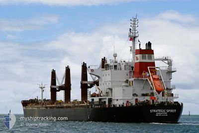
STRATEGIC SPIRIT
Bulk Carrier
Current Trip
| Trip Time | 18 days |
|---|---|
| Trip Distance | 4181.19 морская миля |
| AVG Speed | 7.8 Узлы |
| MAX Speed | 13.3 Узлы |
| Осадка | 9.1 м |
| AVG Wind | 18.2 knots |
| MAX Wind | 40.6 knots |
| MIN Temp | -3.5°C / 25.7°F |
| MAX Temp | 20.5°C / 68.9°F |
| Позиция Получена | 5 m тому назад |
Current Position
| Долгота | -71.02310° |
|---|---|
| Широта | 42.34468° |
| Статус | Moored |
| Скорость | |
| Курс | 268° |
| Район | North Atlantic Ocean |
| Станция | T-AIS |
| Позиция Получена | 5 m тому назад |
Info
Information
The current position of STRATEGIC SPIRIT is in North Atlantic Ocean with coordinates 42.34468° / -71.02310° as reported on 2025-02-14 16:22 by AIS to our vessel tracker app. The vessel's current speed is 0 Узлы and is currently inside the port of BOSTON.
The vessel STRATEGIC SPIRIT (IMO: 9626388, MMSI: 563049700) is a Bulk Carrier that was built in 2012 ( 13 лет ). It's sailing under the flag of [SG] Singapore.
In this page you can find informations about the vessels current position, last detected port calls, and current voyage information. If the vessels is not in coverage by AIS you will find the latest position.
The current position of STRATEGIC SPIRIT is detected by our AIS receivers and we are not responsible for the reliability of the data. The last position was recorded while the vessel was in Coverage by the Ais receivers of our vessel tracking app.
The current draught of STRATEGIC SPIRIT as reported by AIS is 9.1 meters
Weather
| Temperature | -2.3°C / 27.86°F |
|---|---|
| Wind Speed | 14 knots |
| Direction | 295° WNW |
| Pressure | 1028.7 hPa |
| Humidity | 53.7 % |
| Cloud Coverage | --- |
Featured Company
Last Port Calls
| Port | Arrival | Departure | Time In Port |
|---|---|---|---|
| 2025-02-11 20:45 | |||
| 2025-01-21 12:58 | 2025-01-24 20:37 | 3 d | |
| 2025-01-14 10:24 | 2025-01-16 17:13 | 2 d | |
| 2024-12-25 05:54 | 2024-12-29 08:28 | 4 d | |
| 2024-12-14 14:52 | 2024-12-19 11:49 | 4 d |
Most Visited Ports (Last year)
| Port | Arrivals | |
|---|---|---|
| 2 | ||
| 2 | ||
| 2 | ||
| 2 | ||
| 1 | ||
| 1 |
Last Trips
| Origin | Departure | Destination | Arrival | Distance | |
|---|---|---|---|---|---|
| 2025-01-24 20:37 | 2025-02-11 20:45 | 4181.19 морская миля | |||
| 2025-01-16 17:13 | 2025-01-21 12:58 | 1370.84 морская миля | |||
| 2024-12-29 08:28 | 2025-01-14 10:24 | 1414.18 морская миля | |||
| 2024-12-19 11:49 | 2024-12-25 05:54 | 383.97 морская миля | |||
| 2024-11-21 18:33 | 2024-12-14 14:52 | 5391.80 морская миля |
Events
| Время | Событие | Детали | Позиция / Направление | Информация |
|---|---|---|---|---|
| 2025-02-12 02:40 | Статус изменился | Moored Under way using engine |
42.34470 / -71.02279
[US] BOSTON
|
Скорость: Курс: 268° |
| 2025-02-12 02:06 | Окончание движения |
42.34489 / -71.02191
[US] BOSTON
|
Скорость: 0.3 kn Курс: 267° |
|
| 2025-02-12 01:45 | Порт |
|
42.34043 / -71.00830
[US] BOSTON
|
Скорость: 4.3 kn Курс: 306° |
| 2025-02-12 00:20 | Начало движения | 8.36 nm, East of WINTHROP |
42.41152 / -70.79428
US BOS
|
Скорость: 3.1 kn Курс: 234° |
| 2025-02-11 23:49 | Статус изменился | Under way using engine At anchor |
42.41911 / -70.78405
US BOS
|
Скорость: 0.1 kn Курс: 205° |
| 2025-02-11 23:21 | Статус изменился | At anchor Default |
42.41971 / -70.78225
US BOS
|
Скорость: 0.1 kn Курс: 224° |
| 2025-02-11 23:15 | Статус изменился | Default At anchor |
42.41959 / -70.78236
US BOS
|
Скорость: 0.3 kn Курс: 220° |
| 2025-02-11 22:33 | Статус изменился | At anchor Default |
42.41976 / -70.78247
US BOS
|
Скорость: 0.1 kn Курс: 220° |
| 2025-02-11 22:21 | Статус изменился | Default At anchor |
42.41952 / -70.78207
US BOS
|
Скорость: Курс: 231° |
| 2025-02-11 21:51 | Статус изменился | At anchor Default |
42.41942 / -70.78201
US BOS
|
Скорость: 0.1 kn Курс: 233° |