
ALBAYRAK-TR
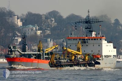
Trailing Suction Hopper Dredger
Current Trip
| Trip Time | 1 h, 20 mins |
|---|---|
| Trip Distance | 3.36 nm |
| AVG Speed | 4.6 Knop |
| MAX Speed | 6.5 Knop |
| Djupgående | 5.3 m |
| AVG Wind | 8.8 knots |
| MAX Wind | 10 knots |
| MIN Temp | 24.6°C / 76.28°F |
| MAX Temp | 24.7°C / 76.46°F |
| Position mottagen | 2024-04-28 15:19 |
Current Position
| Longitud | -13.70985° |
|---|---|
| Latitude | 9.52499° |
| Status | Restricted manoeuverability |
| Fart | |
| Kurs | 123° |
| Område | North Atlantic Ocean |
| Station | T-AIS |
| Position mottagen | 2024-04-28 15:19 |
Info
Information
The current position of ALBAYRAK-TR is in North Atlantic Ocean with coordinates 9.52499° / -13.70985° as reported on 2024-04-28 15:19 by AIS to our vessel tracker app. The vessel's current speed is 0 Knop and is currently inside the port of POINTE NOIRE.
The vessel ALBAYRAK-TR (IMO: 7726847, MMSI: 271049675) is a Trailing Suction Hopper Dredger that was built in 1978 ( 47 År gammal ). It's sailing under the flag of [TR] Turkey.
In this page you can find informations about the vessels current position, last detected port calls, and current voyage information. If the vessels is not in coverage by AIS you will find the latest position.
The current position of ALBAYRAK-TR is detected by our AIS receivers and we are not responsible for the reliability of the data. The last position was recorded while the vessel was in Coverage by the Ais receivers of our vessel tracking app.
The current draught of ALBAYRAK-TR as reported by AIS is 5.3 meters
Weather
| Temperature | 24.8°C / 76.64°F |
|---|---|
| Wind Speed | 10 knots |
| Direction | 51° NE |
| Pressure | 1012.1 hPa |
| Humidity | 84.4 % |
| Cloud Coverage | 100 % |
Featured Company
Last Port Calls
| Port | Arrival | Departure | Time In Port |
|---|---|---|---|
| 2025-02-07 07:12 | |||
| 2025-02-07 02:00 | 2025-02-07 05:52 | 3 h | |
| 2025-02-06 20:16 | 2025-02-07 00:56 | 4 h | |
| 2025-02-06 14:32 | 2025-02-06 19:16 | 4 h | |
| 2025-02-06 09:48 | 2025-02-06 13:40 | 3 h | |
| 2025-02-06 05:12 | 2025-02-06 09:08 | 3 h | |
| 2025-02-06 01:48 | 2025-02-06 04:12 | 2 h | |
| 2025-02-05 22:16 | 2025-02-06 01:04 | 2 h | |
| 2025-02-05 18:16 | 2025-02-05 21:24 | 3 h | |
| 2025-02-05 10:12 | 2025-02-05 17:20 | 7 h |
Most Visited Ports (Last year)
| Port | Arrivals | |
|---|---|---|
| 825 | ||
| 215 |
Last Trips
| Origin | Departure | Destination | Arrival | Distance | |
|---|---|---|---|---|---|
| 2025-02-07 06:52 | 2025-02-07 08:12 | 3.36 nm | |||
| 2025-02-07 01:56 | 2025-02-07 03:00 | 3.98 nm | |||
| 2025-02-06 20:16 | 2025-02-06 21:16 | 2.99 nm | |||
| 2025-02-06 14:40 | 2025-02-06 15:32 | 2.55 nm | |||
| 2025-02-06 10:08 | 2025-02-06 10:48 | 2.38 nm | |||
| 2025-02-06 05:12 | 2025-02-06 06:12 | 4.11 nm | |||
| 2025-02-06 02:04 | 2025-02-06 02:48 | 2.77 nm | |||
| 2025-02-05 22:24 | 2025-02-05 23:16 | 2.68 nm | |||
| 2025-02-05 18:20 | 2025-02-05 19:16 | 2.45 nm | |||
| 2025-02-05 10:24 | 2025-02-05 11:12 | 3.22 nm |
Events
| Tid | Event | Detaljer | Position / Dest | Information |
|---|---|---|---|---|
| 2025-02-07 07:28 | STOPPAR förflyttning |
-4.78475 / 11.82665
[CG] POINTE NOIRE
|
Fart: 0.1 kn Kurs: 140° |
|
| 2025-02-07 07:16 | STARTAR förflyttning |
-4.77891 / 11.83319
[CG] POINTE NOIRE
|
Fart: 4.6 kn Kurs: 214° |
|
| 2025-02-07 07:12 | ANLÄNDER HAMN |
|
-4.77411 / 11.83438
[CG] POINTE NOIRE
|
Fart: 0.1 kn Kurs: 180° |
| 2025-02-07 07:00 | STOPPAR förflyttning | 0.39 nm, North of POINTE NOIRE |
-4.77290 / 11.83489
GN CKY ETA:3107 0730
|
Fart: 0.2 kn Kurs: 180° |
| 2025-02-07 06:36 | STARTAR förflyttning | 2.05 nm, North West of POINTE NOIRE |
-4.75540 / 11.81070
GN CKY ETA:3107 0730
|
Fart: 4.7 kn Kurs: 151° |
| 2025-02-07 06:16 | STOPPAR förflyttning | 2.08 nm, North West of POINTE NOIRE |
-4.75284 / 11.81262
GN CKY ETA:3107 0730
|
Fart: 0.3 kn Kurs: 198° |
| 2025-02-07 05:52 | AVGÅTT HAMN |
|
-4.76644 / 11.82656
GN CKY ETA:3107 0730
|
Fart: 6.5 kn Kurs: 326° |
| 2025-02-07 05:40 | STARTAR förflyttning |
-4.78284 / 11.82957
[CG] POINTE NOIRE
|
Fart: 5.4 kn Kurs: 34° |
|
| 2025-02-07 02:20 | STOPPAR förflyttning |
-4.78475 / 11.82667
[CG] POINTE NOIRE
|
Fart: 0.1 kn Kurs: 116° |
|
| 2025-02-07 02:00 | ANLÄNDER HAMN |
|
-4.77621 / 11.83332
[CG] POINTE NOIRE
|
Fart: 4.3 kn Kurs: 148° |