
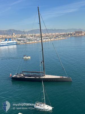
ALEA
Pleasure Craft
Current Trip
| Trip Time | 19 days |
|---|---|
| Trip Distance | 347.35 nm |
| AVG Speed | 8.8 Knop |
| MAX Speed | 14.3 Knop |
| Djupgående | 6.9 m |
| AVG Wind | 15.8 knots |
| MAX Wind | 23 knots |
| MIN Temp | 25°C / 77°F |
| MAX Temp | 26.2°C / 79.16°F |
| Position mottagen | 1 m sen |
Current Position
| Longitud | -63.09164° |
|---|---|
| Latitude | 18.03705° |
| Status | Moored |
| Fart | |
| Kurs | 329° |
| Område | Caribbean Sea |
| Station | T-AIS |
| Position mottagen | 1 m sen |
Info
Information
The current position of ALEA is in Caribbean Sea with coordinates 18.03705° / -63.09164° as reported on 2025-03-07 08:20 by AIS to our vessel tracker app. The vessel's current speed is 0 Knop and is currently inside the port of ST MAARTEN.
The vessel ALEA (IMO: 9957165, MMSI: 319241300) is a Pleasure Craft It's sailing under the flag of [KY] Cayman Is.
In this page you can find informations about the vessels current position, last detected port calls, and current voyage information. If the vessels is not in coverage by AIS you will find the latest position.
The current position of ALEA is detected by our AIS receivers and we are not responsible for the reliability of the data. The last position was recorded while the vessel was in Coverage by the Ais receivers of our vessel tracking app.
The current draught of ALEA as reported by AIS is 6.9 meters
Weather
| Temperature | 25.8°C / 78.44°F |
|---|---|
| Wind Speed | 9 knots |
| Direction | 136° SE |
| Pressure | 1014.7 hPa |
| Humidity | 74.7 % |
| Cloud Coverage | 49 % |
Featured Company
Last Port Calls
| Port | Arrival | Departure | Time In Port |
|---|---|---|---|
| 2025-03-06 13:33 | |||
| 2025-01-07 13:47 | 2025-02-14 20:08 |
Most Visited Ports (Last year)
| Port | Arrivals | |
|---|---|---|
| 8 | ||
| 2 | ||
| 2 | ||
| 1 | ||
| 1 | ||
| 1 |
Last Trips
| Origin | Departure | Destination | Arrival | Distance | |
|---|---|---|---|---|---|
| 2025-02-14 16:08 | 2025-03-06 09:33 | 347.35 nm | |||
| 2024-12-26 13:00 | 2025-01-07 09:47 | 371.00 nm |
Events
| Tid | Event | Detaljer | Position / Dest | Information |
|---|---|---|---|---|
| 2025-03-06 14:08 | Status ändrad | Moored Under way using engine |
18.03704 / -63.09161
[SX] ST MAARTEN
|
Fart: Kurs: 330° |
| 2025-03-06 13:33 | ANLÄNDER HAMN |
|
18.03562 / -63.09445
[SX] ST MAARTEN
|
Fart: 2.1 kn Kurs: 63° |
| 2025-03-06 13:22 | STOPPAR förflyttning | 0.32 nm, South West of ST MAARTEN |
18.03455 / -63.09695
ST MAARTEN
|
Fart: 0.3 kn Kurs: 81° |
| 2025-03-06 13:14 | STARTAR förflyttning | 0.65 nm, South West of ST MAARTEN |
18.03290 / -63.10260
ST MAARTEN
|
Fart: 3.6 kn Kurs: 70° |
| 2025-03-06 13:02 | STOPPAR förflyttning | 0.79 nm, South West of ST MAARTEN |
18.03259 / -63.10516
ST MAARTEN
|
Fart: 0.1 kn Kurs: 342° |
| 2025-03-06 12:38 | Byter havsområde | Sint-Maarten part of the Caribbean Sea Saint-Martin part of the Caribbean Sea |
18.04000 / -63.14629
Caribbean Sea
|
Fart: 11 kn Kurs: 130.5° |
| 2025-03-06 11:59 | STARTAR förflyttning | 0.97 nm, North West of MARIGOT |
18.07748 / -63.09576
ST MAARTEN
|
Fart: 8.3 kn Kurs: 293.4° |
| 2025-03-05 23:08 | STOPPAR förflyttning | 0.86 nm, North of MARIGOT |
18.07625 / -63.09363
ST MAARTEN
|
Fart: 0.2 kn Kurs: 123° |
| 2025-03-05 22:56 | STARTAR förflyttning | 1.48 nm, North West of MARIGOT |
18.08529 / -63.09915
ST MAARTEN
|
Fart: 6.5 kn Kurs: 165.9° |
| 2025-03-05 20:04 | STOPPAR förflyttning | 1.61 nm, North of MARIGOT |
18.08785 / -63.09897
ST MAARTEN
|
Fart: 0.2 kn Kurs: 134° |