
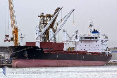
ALITHIA
Bulk Carrier
Current Trip
| Trip Time | 2 days |
|---|---|
| Trip Distance | 600.32 nm |
| AVG Speed | 11.2 Knop |
| MAX Speed | 13.9 Knop |
| Djupgående | 8.6 m |
| AVG Wind | 9.9 knots |
| MAX Wind | 16.1 knots |
| MIN Temp | 19.6°C / 67.28°F |
| MAX Temp | 28.3°C / 82.94°F |
| Position mottagen | 2 d sen |
Current Position
| Longitud | -96.95422° |
|---|---|
| Latitude | 26.90451° |
| Status | Under way using engine |
| Fart | 11.8 Knop |
| Kurs | 181.8° |
| Område | Gulf of Mexico |
| Station | T-AIS |
| Position mottagen | 2 d sen |
Info
Information
The current position of ALITHIA is in Gulf of Mexico with coordinates 26.90451° / -96.95422° as reported on 2025-02-11 17:21 by AIS to our vessel tracker app. The vessel's current speed is 11.8 Knop and is currently inside the port of BROWNSVILLE.
The vessel ALITHIA (IMO: 9595840, MMSI: 256682000) is a Bulk Carrier that was built in 2012 ( 13 År gammal ). It's sailing under the flag of [MT] Malta.
In this page you can find informations about the vessels current position, last detected port calls, and current voyage information. If the vessels is not in coverage by AIS you will find the latest position.
The current position of ALITHIA is detected by our AIS receivers and we are not responsible for the reliability of the data. The last position was recorded while the vessel was in Coverage by the Ais receivers of our vessel tracking app.
The current draught of ALITHIA as reported by AIS is 8.6 meters
Weather
| Temperature | 10.7°C / 51.26°F |
|---|---|
| Wind Speed | 15 knots |
| Direction | 357° N |
| Pressure | 1025.2 hPa |
| Humidity | 68.4 % |
| Cloud Coverage | 100 % |
Featured Company
Last Port Calls
| Port | Arrival | Departure | Time In Port |
|---|---|---|---|
| 2025-02-12 06:07 | |||
| 2025-02-05 22:37 | 2025-02-09 18:55 | 3 d | |
| 2025-02-02 07:49 | 2025-02-02 08:01 | 11 m | |
| 2025-02-01 18:06 | |||
| 2025-02-01 17:33 | 2025-02-01 17:47 | 14 m | |
| 2025-01-07 02:52 | 2025-01-08 09:55 | 1 d | |
| 2024-12-24 18:32 | 2025-01-03 19:32 | 10 d | |
| 2024-12-03 12:43 | 2024-12-07 23:00 | 4 d |
Most Visited Ports (Last year)
| Port | Arrivals | |
|---|---|---|
| 3 | ||
| 2 | ||
| 2 | ||
| 2 | ||
| 2 | ||
| 1 |
Last Trips
| Origin | Departure | Destination | Arrival | Distance | |
|---|---|---|---|---|---|
| 2025-02-09 12:55 | 2025-02-12 00:07 | 600.32 nm | |||
| 2025-02-02 03:01 | 2025-02-05 16:37 | 861.95 nm | |||
| 2025-02-01 12:47 | 2025-02-02 02:49 | 1.98 nm | |||
| 2025-02-01 12:47 | 2025-02-01 13:06 | 0.90 nm | |||
| 2025-01-08 11:55 | 2025-02-01 12:33 | 6774.01 nm | |||
| 2025-01-03 21:32 | 2025-01-07 04:52 | 904.66 nm | |||
| 2024-12-08 02:00 | 2024-12-24 20:32 | 1639.88 nm | |||
| 2024-11-23 02:47 | 2024-12-03 15:43 | 2215.52 nm |
Events
| Tid | Event | Detaljer | Position / Dest | Information |
|---|---|---|---|---|
| 2025-02-12 07:23 | STOPPAR förflyttning |
25.95873 / -97.37758
[US] BROWNSVILLE
|
Fart: Kurs: 68° |
|
| 2025-02-12 06:07 | ANLÄNDER HAMN |
|
25.97319 / -97.33862
[US] BROWNSVILLE
|
Fart: 6.3 kn Kurs: 249° |
| 2025-02-12 03:51 | STARTAR förflyttning | 19.3 nm, North East of BROWNSVILLE |
26.08537 / -97.03975
BROWNSVILLE
|
Fart: 5.8 kn Kurs: 219° |
| 2025-02-11 22:31 | STOPPAR förflyttning | 19.71 nm, North East of BROWNSVILLE |
26.09431 / -97.03561
BROWNSVILLE
|
Fart: 0.1 kn Kurs: 144° |
| 2025-02-11 17:27 | Status ändrad | Default Under way using engine |
26.88671 / -96.95473
BROWNSVILLE
|
Fart: 11.8 kn Kurs: 181.8° |
| 2025-02-11 17:21 | Byter havsområde | United States part of the Gulf of Mexico Bahamas part of the North Atlantic Ocean |
26.90451 / -96.95422
Gulf of Mexico
BROWNSVILLE
|
Fart: 11.8 kn Kurs: 181.8° |
| 2025-02-11 17:21 | UTANFÖR täckningsområde |
26.90451 / -96.95422
Gulf of Mexico
BROWNSVILLE
|
Fart: 11.8 kn Kurs: 181.8° |
|
| 2025-02-11 17:21 | Status ändrad | Under way using engine Default |
26.90565 / -96.95417
BROWNSVILLE
|
Fart: 11.8 kn Kurs: 178° |
| 2025-02-11 17:19 | I täckningsområde |
26.90451 / -96.95422
Gulf of Mexico
BROWNSVILLE
|
Fart: 11.8 kn Kurs: 181.8° |
|
| 2025-02-09 18:43 | UTANFÖR täckningsområde |
29.79661 / -90.00835
North Atlantic Ocean
BROWNSVILLE
|
Fart: 13.6 kn Kurs: 206.9° |