
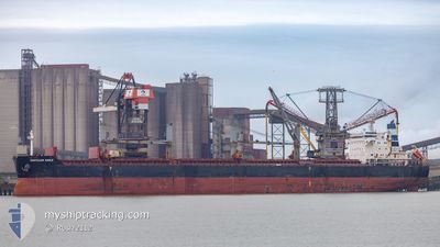
ANATOLIAN EAGLE
Bulk Carrier
Current Trip
| Time Travelled | 5 days |
|---|---|
| Remaining Time | --- |
| Distance Travelled | 844.79 nm |
| Remaining Distance | 192.17 nm |
| AVG Speed | 9.2 Knop |
| MAX Speed | 12.9 Knop |
| AVG Wind | 19.3 knots |
| MAX Wind | 32.3 knots |
| MIN Temp | -2.4°C / 27.68°F |
| MAX Temp | 12.9°C / 55.22°F |
| Djupgående | 6.7 m |
| Position mottagen | 2 m sen |
Current Position
| Longitud | 28.84434° |
|---|---|
| Latitude | 40.93254° |
| Status | At anchor |
| Fart | 0.3 Knop |
| Kurs | 73° |
| Område | Sea of Marmara |
| Station | T-AIS |
| Position mottagen | 2 m sen |
Info
Information
The current position of ANATOLIAN EAGLE is in Sea of Marmara with coordinates 40.93254° / 28.84434° as reported on 2025-02-11 16:23 by AIS to our vessel tracker app. The vessel's current speed is 0.3 Knop and is heading at the port of CONSTANTA. The estimated time of arrival as calculated by MyShipTracking vessel tracking app is 2025-02-11 12:00 LT
The vessel ANATOLIAN EAGLE (IMO: 9490820, MMSI: 538006935) is a Bulk Carrier that was built in 2011 ( 14 År gammal ). It's sailing under the flag of [MH] Marshall Is.
In this page you can find informations about the vessels current position, last detected port calls, and current voyage information. If the vessels is not in coverage by AIS you will find the latest position.
The current position of ANATOLIAN EAGLE is detected by our AIS receivers and we are not responsible for the reliability of the data. The last position was recorded while the vessel was in Coverage by the Ais receivers of our vessel tracking app.
The current draught of ANATOLIAN EAGLE as reported by AIS is 6.7 meters
Weather
| Temperature | 3.4°C / 38.12°F |
|---|---|
| Wind Speed | 13 knots |
| Direction | 10° N |
| Pressure | 1029.1 hPa |
| Humidity | 86.6 % |
| Cloud Coverage | 86 % |
Featured Company
Last Port Calls
| Port | Arrival | Departure | Time In Port |
|---|---|---|---|
| 2025-01-29 07:25 | 2025-02-06 07:57 | 8 d | |
| 2025-01-06 14:36 | 2025-01-11 09:22 | 4 d | |
| 2024-12-16 12:41 | 2024-12-24 16:27 | 8 d |
Most Visited Ports (Last year)
| Port | Arrivals | |
|---|---|---|
| 3 | ||
| 3 | ||
| 2 | ||
| 1 | ||
| 1 | ||
| 1 |
Last Trips
| Origin | Departure | Destination | Arrival | Distance | |
|---|---|---|---|---|---|
| 2025-01-11 09:22 | 2025-01-29 07:25 | 4505.14 nm | |||
| 2024-12-24 16:27 | 2025-01-06 14:36 | 1077.82 nm | |||
| 2024-11-04 10:24 | 2024-12-16 12:41 | 4806.18 nm |
Events
| Tid | Event | Detaljer | Position / Dest | Information |
|---|---|---|---|---|
| 2025-02-10 02:38 | Status ändrad | At anchor Default |
40.93315 / 28.84455
ROCND
|
Fart: Kurs: 54° |
| 2025-02-10 02:35 | Status ändrad | Default At anchor |
40.93320 / 28.84452
ROCND
|
Fart: 0.1 kn Kurs: 57° |
| 2025-02-09 14:14 | Status ändrad | At anchor Default |
40.93245 / 28.84493
ROCND
|
Fart: 0.5 kn Kurs: 6° |
| 2025-02-09 14:11 | Status ändrad | Default At anchor |
40.93242 / 28.84523
ROCND
|
Fart: 0.6 kn Kurs: 342° |
| 2025-02-09 13:59 | Status ändrad | At anchor Under way using engine |
40.93341 / 28.84683
ROCND
|
Fart: 0.2 kn Kurs: 3° |
| 2025-02-09 13:59 | STOPPAR förflyttning | 1.64 nm, South East of YESILKOY |
40.93336 / 28.84690
ROCND
|
Fart: 0.3 kn Kurs: 4° |
| 2025-02-09 05:46 | Status ändrad | Under way using engine Default |
40.58401 / 27.22408
ROCND
|
Fart: 10.1 kn Kurs: 66° |
| 2025-02-09 05:38 | Status ändrad | Default Under way using engine |
40.57535 / 27.19667
ROCND
|
Fart: 10.7 kn Kurs: 67.3° |
| 2025-02-09 05:18 | Status ändrad | Under way using engine Default |
40.55112 / 27.12348
ROCND
|
Fart: 9.5 kn Kurs: 67° |
| 2025-02-09 05:18 | I täckningsområde |
40.55289 / 27.12792
Sea of Marmara
ROCND
|
Fart: 10.4 kn Kurs: 61.9° |