
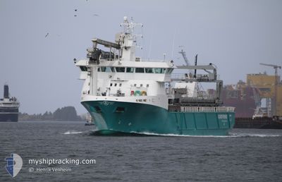
AQUA FJELL
General Cargo
Current Trip
FISHFARMS
| Time Travelled | 5 days |
|---|---|
| Remaining Time | --- |
| Distance Travelled | 813.38 nm |
| Remaining Distance | --- |
| AVG Speed | 10.9 Knop |
| MAX Speed | 12.7 Knop |
| AVG Wind | 11.6 knots |
| MAX Wind | 27 knots |
| MIN Temp | -7.7°C / 18.14°F |
| MAX Temp | 6.1°C / 42.98°F |
| Djupgående | 6 m |
| Position mottagen | 2 m sen |
Current Position
| Longitud | 12.09974° |
|---|---|
| Latitude | 65.18757° |
| Status | Under way using engine |
| Fart | 10.6 Knop |
| Kurs | 197.4° |
| Område | Norwegian Sea |
| Station | T-AIS |
| Position mottagen | 2 m sen |
Information
The current position of AQUA FJELL is in Norwegian Sea with coordinates 65.18757° / 12.09974° as reported on 2025-02-23 22:04 by AIS to our vessel tracker app. The vessel's current speed is 10.6 Knop
The vessel AQUA FJELL (IMO: 9688960, MMSI: 257659800) is a General Cargo that was built in 2014 ( 11 År gammal ). It's sailing under the flag of [NO] Norway.
In this page you can find informations about the vessels current position, last detected port calls, and current voyage information. If the vessels is not in coverage by AIS you will find the latest position.
The current position of AQUA FJELL is detected by our AIS receivers and we are not responsible for the reliability of the data. The last position was recorded while the vessel was in Coverage by the Ais receivers of our vessel tracking app.
The current draught of AQUA FJELL as reported by AIS is 6 meters
Weather
| Temperature | 4.2°C / 39.56°F |
|---|---|
| Wind Speed | 19 knots |
| Direction | 119° ESE |
| Pressure | 1003.2 hPa |
| Humidity | 83.2 % |
| Cloud Coverage | 100 % |
Featured Company
Last Port Calls
| Port | Arrival | Departure | Time In Port |
|---|---|---|---|
| 2025-02-18 21:13 | 2025-02-18 22:04 | 50 m | |
| 2025-02-18 12:27 | 2025-02-18 20:26 | 7 h | |
| 2025-02-17 09:02 | 2025-02-18 12:02 | 1 d | |
| 2025-02-14 16:00 | 2025-02-15 12:47 | 20 h | |
| 2025-02-12 16:47 | 2025-02-12 17:10 | 23 m | |
| 2025-02-08 15:26 | 2025-02-10 16:35 | 2 d | |
| 2025-02-02 18:26 | 2025-02-08 11:57 | 5 d | |
| 2025-02-01 07:11 | 2025-02-02 14:46 | 1 d | |
| 2025-01-31 23:05 | 2025-01-31 23:15 | 10 m | |
| 2025-01-31 16:01 | 2025-01-31 16:14 | 12 m |
Last Trips
| Origin | Departure | Destination | Arrival | Distance | |
|---|---|---|---|---|---|
| 2025-02-18 21:26 | 2025-02-18 22:13 | 8.60 nm | |||
| 2025-02-18 13:02 | 2025-02-18 13:27 | 3.76 nm | |||
| 2025-02-15 13:47 | 2025-02-17 10:02 | 230.83 nm | |||
| 2025-02-12 18:10 | 2025-02-14 17:00 | 366.86 nm | |||
| 2025-02-10 17:35 | 2025-02-12 17:47 | 231.37 nm | |||
| 2025-02-08 12:57 | 2025-02-08 16:26 | 40.59 nm | |||
| 2025-02-02 15:46 | 2025-02-02 19:26 | 40.38 nm | |||
| 2025-02-01 00:15 | 2025-02-01 08:11 | 88.15 nm | |||
| 2025-01-31 17:14 | 2025-02-01 00:05 | 79.38 nm | |||
| 2025-01-31 11:00 | 2025-01-31 17:01 | 66.35 nm |
Events
| Tid | Event | Detaljer | Position / Dest | Information |
|---|---|---|---|---|
| 2025-02-23 20:02 | STARTAR förflyttning | 19.51 nm, East of VENNESUND |
65.24573 / 12.81011
FISHFARMS
|
Fart: 8 kn Kurs: 243.8° |
| 2025-02-23 19:17 | STOPPAR förflyttning | 19.73 nm, East of VENNESUND |
65.24811 / 12.81832
FISHFARMS
|
Fart: 0.1 kn Kurs: 216° |
| 2025-02-23 17:59 | STARTAR förflyttning | 11.89 nm, South East of VENNESUND |
65.10588 / 12.43224
FISHFARMS
|
Fart: 8.4 kn Kurs: 265.8° |
| 2025-02-23 16:31 | STOPPAR förflyttning | 12.03 nm, South East of VENNESUND |
65.10742 / 12.44126
FISHFARMS
|
Fart: Kurs: 236° |
| 2025-02-23 15:56 | STARTAR förflyttning | 8.37 nm, South East of VENNESUND |
65.13693 / 12.31440
FISHFARMS
|
Fart: 7.9 kn Kurs: 261.9° |
| 2025-02-23 15:08 | STOPPAR förflyttning | 8.49 nm, South East of VENNESUND |
65.13854 / 12.32268
FISHFARMS
|
Fart: 0.1 kn Kurs: 232° |
| 2025-02-23 14:35 | STARTAR förflyttning | 5.3 nm, East of VENNESUND |
65.20913 / 12.25007
FISHFARMS
|
Fart: 7.8 kn Kurs: 80.1° |
| 2025-02-23 13:22 | STOPPAR förflyttning | 5.14 nm, East of VENNESUND |
65.20960 / 12.24401
FISHFARMS
|
Fart: 0.3 kn Kurs: 353° |
| 2025-02-23 05:53 | STARTAR förflyttning | 12.78 nm, West of SANDNESSJOEN |
66.09254 / 12.14621
FISHFARMS
|
Fart: 9 kn Kurs: 209.5° |
| 2025-02-23 03:53 | STOPPAR förflyttning | 12.74 nm, West of SANDNESSJOEN |
66.09800 / 12.15255
FISHFARMS
|
Fart: 0.1 kn Kurs: 14° |