
ARIEL
Tanker
Current Trip
DUINKERKEN NORD FRA
| Time Travelled | 7 h, 2 mins |
|---|---|
| Remaining Time | --- |
| Distance Travelled | --- |
| Remaining Distance | --- |
| AVG Speed | --- |
| MAX Speed | --- |
| AVG Wind | --- |
| MAX Wind | --- |
| MIN Temp | --- |
| MAX Temp | --- |
| Djupgående | 2.4 m |
| Position mottagen | 7 h, 1 m sen |
Current Position
| Longitud | 3.50353° |
|---|---|
| Latitude | 50.97642° |
| Status | Under way using engine |
| Fart | 5 Knop |
| Kurs | 235° |
| Område | North Sea |
| Station | T-AIS |
| Position mottagen | 7 h, 1 m sen |
Info
Information
The current position of ARIEL is in North Sea with coordinates 50.97642° / 3.50353° as reported on 2026-01-10 10:36 by AIS to our vessel tracker app. The vessel's current speed is 5 Knop
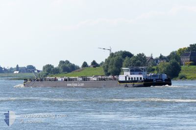
The vessel ARIEL (MMSI: 244375515) is a Tanker It's sailing under the flag of [NL] Netherlands.
In this page you can find informations about the vessels current position, last detected port calls, and current voyage information. If the vessels is not in coverage by AIS you will find the latest position.
The current position of ARIEL is detected by our AIS receivers and we are not responsible for the reliability of the data. The last position was recorded while the vessel was in Coverage by the Ais receivers of our vessel tracking app.
The current draught of ARIEL as reported by AIS is 2.4 meters
Weather
| Temperature | -0.3°C / 31.46°F |
|---|---|
| Wind Speed | 7 knots |
| Direction | 16° NNE |
| Pressure | 1016.6 hPa |
| Humidity | 93.7 % |
| Cloud Coverage | 97 % |
Featured Company
Last Port Calls
| Port | Arrival | Departure | Time In Port |
|---|---|---|---|
| 2026-01-10 11:27 | 2026-01-10 11:36 | 9 m | |
| 2026-01-10 07:17 | 2026-01-10 09:18 | 2 h | |
| 2026-01-09 19:30 | 2026-01-10 06:15 | 10 h | |
| 2026-01-09 17:05 | 2026-01-09 17:26 | 21 m | |
| 2026-01-05 14:30 | 2026-01-09 09:56 | 3 d | |
| 2026-01-04 23:31 | 2026-01-05 13:11 | 13 h | |
| 2026-01-04 12:14 | 2026-01-04 15:44 | 3 h | |
| 2025-12-30 12:18 | 2025-12-30 12:37 | 19 m | |
| 2025-12-25 11:57 | 2025-12-30 11:16 | 4 d | |
| 2025-12-23 14:38 | 2025-12-24 08:17 | 17 h |
Most Visited Ports (Last year)
| Port | Arrivals | |
|---|---|---|
| 33 | ||
| 19 | ||
| 18 | ||
| 15 | ||
| 14 | ||
| 14 |
Last Trips
| Origin | Departure | Destination | Arrival | Distance | |
|---|---|---|---|---|---|
| 2026-01-10 09:18 | 2026-01-10 11:27 | 8.48 nm | |||
| 2026-01-10 06:15 | 2026-01-10 07:17 | 7.97 nm | |||
| 2026-01-09 17:26 | 2026-01-09 19:30 | 11.91 nm | |||
| 2026-01-09 09:56 | 2026-01-09 17:05 | 53.76 nm | |||
| 2026-01-05 13:11 | 2026-01-05 14:30 | 10.16 nm | |||
| 2026-01-04 15:44 | 2026-01-04 23:31 | 55.08 nm | |||
| 2025-12-30 12:37 | 2026-01-04 12:14 | 210.00 nm | |||
| 2025-12-30 11:16 | 2025-12-30 12:18 | 8.88 nm | |||
| 2025-12-24 08:17 | 2025-12-25 11:57 | 23.12 nm | |||
| 2025-12-22 17:01 | 2025-12-23 14:38 | 41.17 nm |
Events
| Tid | Event | Detaljer | Position / Dest | Information |
|---|---|---|---|---|
| 2026-01-10 14:30 | STARTAR förflyttning | 1.19 nm, North East of KORTRIJK |
50.84500 / 3.28833
DUINKERKEN NORD FRA
|
Fart: 4 kn Kurs: -1° |
| 2026-01-10 14:06 | STOPPAR förflyttning | 2.06 nm, North East of KORTRIJK |
50.85500 / 3.30500
DUINKERKEN NORD FRA
|
Fart: Kurs: -1° |
| 2026-01-10 12:12 | STARTAR förflyttning | 6.68 nm, South West of DEINZE |
50.90667 / 3.40167
DUINKERKEN NORD FRA
|
Fart: 5 kn Kurs: 232° |
| 2026-01-10 10:36 | UTANFÖR täckningsområde |
50.97642 / 3.50353
North Sea
DUINKERKEN NORD FRA
|
Fart: 5 kn Kurs: 234.1° |
|
| 2026-01-10 10:36 | Status ändrad | Under way using engine Default |
50.97642 / 3.50353
DUINKERKEN NORD FRA
|
Fart: Kurs: -1° |
| 2026-01-10 10:36 | STARTAR förflyttning | 0.98 nm, South West of DEINZE |
50.97642 / 3.50353
DUINKERKEN NORD FRA
|
Fart: 5 kn Kurs: 235° |
| 2026-01-10 10:36 | AVGÅTT HAMN |
|
50.97642 / 3.50353
DUINKERKEN NORD FRA
|
Fart: Kurs: -1° |
| 2026-01-10 10:27 | STOPPAR förflyttning |
50.98333 / 3.51667
[BE] DEINZE
|
Fart: Kurs: -1° |
|
| 2026-01-10 10:27 | I täckningsområde |
50.97642 / 3.50353
North Sea
DUINKERKEN NORD FRA
|
Fart: 5 kn Kurs: 234.1° |
|
| 2026-01-10 10:27 | ANLÄNDER HAMN |
|
50.98333 / 3.51667
[BE] DEINZE
|
Fart: 2.6 kn Kurs: 219° |