
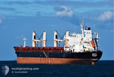
BETTY
Bulk Carrier
Current Trip
| Trip Time | 3 days |
|---|---|
| Trip Distance | 187.78 nm |
| AVG Speed | 8.8 Knop |
| MAX Speed | 13.2 Knop |
| Djupgående | 7.6 m |
| AVG Wind | 6.4 knots |
| MAX Wind | 15 knots |
| MIN Temp | 22.7°C / 72.86°F |
| MAX Temp | 28.9°C / 84.02°F |
| Position mottagen | 3 d sen |
Current Position
| Longitud | -47.01038° |
|---|---|
| Latitude | -24.90801° |
| Status | Under way using engine |
| Fart | 12.3 Knop |
| Kurs | 229.5° |
| Område | South Atlantic Ocean |
| Station | T-AIS |
| Position mottagen | 3 d sen |
Info
Information
The current position of BETTY is in South Atlantic Ocean with coordinates -24.90801° / -47.01038° as reported on 2025-03-02 23:24 by AIS to our vessel tracker app. The vessel's current speed is 12.3 Knop and is currently inside the port of PARANAGUA.
The vessel BETTY (IMO: 9522881, MMSI: 538009422) is a Bulk Carrier that was built in 2011 ( 14 År gammal ). It's sailing under the flag of [MH] Marshall Is.
In this page you can find informations about the vessels current position, last detected port calls, and current voyage information. If the vessels is not in coverage by AIS you will find the latest position.
The current position of BETTY is detected by our AIS receivers and we are not responsible for the reliability of the data. The last position was recorded while the vessel was in Coverage by the Ais receivers of our vessel tracking app.
The current draught of BETTY as reported by AIS is 7.6 meters
Weather
| Temperature | 24.3°C / 75.74°F |
|---|---|
| Wind Speed | 2 knots |
| Direction | 64° ENE |
| Pressure | 1018 hPa |
| Humidity | 75.1 % |
| Cloud Coverage | 100 % |
Featured Company
Most Visited Ports (Last year)
| Port | Arrivals | |
|---|---|---|
| 1 | ||
| 1 | ||
| 1 | ||
| 1 | ||
| 1 | ||
| 1 |
Events
| Tid | Event | Detaljer | Position / Dest | Information |
|---|---|---|---|---|
| 2025-03-03 08:56 | STOPPAR förflyttning |
-25.50211 / -48.51900
[BR] PARANAGUA
|
Fart: 0.3 kn Kurs: 91° |
|
| 2025-03-03 08:44 | ANLÄNDER HAMN |
|
-25.49877 / -48.51878
[BR] PARANAGUA
|
Fart: 5.1 kn Kurs: 259° |
| 2025-03-02 23:29 | Status ändrad | Default Under way using engine |
-24.91919 / -47.02395
BRSSZ>BRPNG
|
Fart: 12.3 kn Kurs: 229.5° |
| 2025-03-02 23:24 | UTANFÖR täckningsområde |
-24.90801 / -47.01038
South Atlantic Ocean
BRSSZ>BRPNG
|
Fart: 12.3 kn Kurs: 229.5° |
|
| 2025-03-02 22:04 | Status ändrad | Under way using engine Default |
-24.73174 / -46.78356
BRSSZ>BRPNG
|
Fart: 11.6 kn Kurs: 229° |
| 2025-03-02 21:56 | Status ändrad | Default Under way using engine |
-24.71547 / -46.76273
BRSSZ>BRPNG
|
Fart: 11.6 kn Kurs: 229.1° |
| 2025-03-02 21:54 | Status ändrad | Under way using engine Default |
-24.70991 / -46.75546
BRSSZ>BRPNG
|
Fart: 11.5 kn Kurs: 229° |
| 2025-03-02 21:38 | I täckningsområde |
-24.70991 / -46.75546
South Atlantic Ocean
BRSSZ>BRPNG
|
Fart: 11.6 kn Kurs: 229.1° |
|
| 2025-03-02 17:38 | Status ändrad | Default Under way using engine |
-24.01393 / -46.34250
BRSSZ>BRPNG
|
Fart: 8.8 kn Kurs: 230.9° |
| 2025-03-02 17:31 | UTANFÖR täckningsområde |
-23.99617 / -46.33079
South Atlantic Ocean
BRSSZ>BRPNG
|
Fart: 8.8 kn Kurs: 230.9° |