
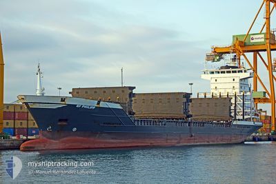
BF PHILIPP
Container Ship
Current Trip
| Time Travelled | 11 h, 21 mins |
|---|---|
| Remaining Time | 1 day |
| Distance Travelled | 135.27 nm |
| Remaining Distance | 346.31 nm |
| AVG Speed | 13.3 Knop |
| MAX Speed | 15.3 Knop |
| AVG Wind | 10.6 knots |
| MAX Wind | 12.8 knots |
| MIN Temp | 5.3°C / 41.54°F |
| MAX Temp | 6.2°C / 43.16°F |
| Djupgående | 6.3 m |
| Position mottagen | 1 h, 20 m sen |
Current Position
| Longitud | 5.02867° |
|---|---|
| Latitude | 53.93967° |
| Status | Under way using engine |
| Fart | 13.4 Knop |
| Kurs | 21° |
| Område | North Sea |
| Station | T-AIS |
| Position mottagen | 1 h, 20 m sen |
Info
Information
The current position of BF PHILIPP is in North Sea with coordinates 53.93967° / 5.02867° as reported on 2025-02-08 23:08 by AIS to our vessel tracker app. The vessel's current speed is 13.4 Knop and is heading at the port of GOTEBORG. The estimated time of arrival as calculated by MyShipTracking vessel tracking app is 2025-02-10 00:59 LT
The vessel BF PHILIPP (IMO: 9123324, MMSI: 304688000) is a Container Ship that was built in 1996 ( 29 År gammal ). It's sailing under the flag of [AG] Antigua Barbuda.
In this page you can find informations about the vessels current position, last detected port calls, and current voyage information. If the vessels is not in coverage by AIS you will find the latest position.
The current position of BF PHILIPP is detected by our AIS receivers and we are not responsible for the reliability of the data. The last position was recorded while the vessel was in Coverage by the Ais receivers of our vessel tracking app.
The current draught of BF PHILIPP as reported by AIS is 6.3 meters
Weather
| Temperature | 5.8°C / 42.44°F |
|---|---|
| Wind Speed | 10 knots |
| Direction | 85° E |
| Pressure | 1027.5 hPa |
| Humidity | 80.8 % |
| Cloud Coverage | 100 % |
Featured Company
Last Port Calls
| Port | Arrival | Departure | Time In Port |
|---|---|---|---|
| 2025-02-08 06:39 | 2025-02-08 13:08 | 6 h | |
| 2025-02-05 18:10 | 2025-02-07 15:42 | 1 d | |
| 2025-02-02 09:21 | 2025-02-02 19:15 | 9 h | |
| 2025-01-29 22:17 | 2025-01-31 16:35 | 1 d | |
| 2025-01-27 08:36 | 2025-01-27 23:47 | 15 h | |
| 2025-01-22 20:25 | 2025-01-25 13:25 | 2 d | |
| 2025-01-19 22:13 | 2025-01-20 14:29 | 16 h | |
| 2025-01-17 02:02 | 2025-01-17 16:17 | 14 h | |
| 2025-01-14 16:17 | 2025-01-15 01:29 | 9 h | |
| 2025-01-11 08:02 | 2025-01-12 03:21 | 19 h |
Last Trips
| Origin | Departure | Destination | Arrival | Distance | |
|---|---|---|---|---|---|
| 2025-02-07 16:42 | 2025-02-08 07:39 | 98.33 nm | |||
| 2025-02-02 20:15 | 2025-02-05 19:10 | 568.61 nm | |||
| 2025-01-31 17:35 | 2025-02-02 10:21 | 561.37 nm | |||
| 2025-01-28 00:47 | 2025-01-29 23:17 | 565.75 nm | |||
| 2025-01-25 14:25 | 2025-01-27 09:36 | 561.45 nm | |||
| 2025-01-20 15:29 | 2025-01-22 21:25 | 566.16 nm | |||
| 2025-01-17 17:17 | 2025-01-19 23:13 | 562.89 nm | |||
| 2025-01-15 02:29 | 2025-01-17 03:02 | 566.06 nm | |||
| 2025-01-12 04:21 | 2025-01-14 17:17 | 628.47 nm | |||
| 2025-01-09 05:16 | 2025-01-11 09:02 | 570.54 nm |
Events
| Tid | Event | Detaljer | Position / Dest | Information |
|---|---|---|---|---|
| 2025-02-08 23:15 | Status ändrad | Default Under way using engine |
53.96600 / 5.04433
SEGOT
|
Fart: 13.4 kn Kurs: 21° |
| 2025-02-08 23:08 | UTANFÖR täckningsområde |
53.93967 / 5.02867
North Sea
SEGOT
|
Fart: 13.4 kn Kurs: 21° |
|
| 2025-02-08 22:49 | Status ändrad | Under way using engine Default |
53.87400 / 4.98467
SEGOT
|
Fart: 13.5 kn Kurs: 21° |
| 2025-02-08 22:39 | I täckningsområde |
53.87400 / 4.98467
North Sea
SEGOT
|
Fart: 13.6 kn Kurs: 22° |
|
| 2025-02-08 21:49 | Status ändrad | Default Under way using engine |
53.66117 / 4.85400
SEGOT
|
Fart: 13.5 kn Kurs: 18° |
| 2025-02-08 21:41 | UTANFÖR täckningsområde |
53.63250 / 4.83833
North Sea
SEGOT
|
Fart: 13.5 kn Kurs: 18° |
|
| 2025-02-08 17:03 | Status ändrad | Under way using engine Default |
52.72117 / 4.12167
SEGOT
|
Fart: 13.3 kn Kurs: 34° |
| 2025-02-08 17:00 | Status ändrad | Default Under way using engine |
52.71350 / 4.11300
SEGOT
|
Fart: 13.3 kn Kurs: 36° |
| 2025-02-08 13:08 | AVGÅTT HAMN |
|
51.96200 / 4.08200
SEGOT
|
Fart: 10.7 kn Kurs: 64° |
| 2025-02-08 12:37 | STARTAR förflyttning |
51.95183 / 3.99217
[NL] MAASVLAKTE - ROTTERDAM
|
Fart: 4.3 kn Kurs: 60° |