
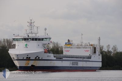
BORE WAY
Cargo
Current Trip
| Time Travelled | 3 days |
|---|---|
| Remaining Time | 15 h, 51 mins |
| Distance Travelled | 958.68 nm |
| Remaining Distance | 277.02 nm |
| AVG Speed | 13.3 Knop |
| MAX Speed | 16.4 Knop |
| AVG Wind | 17 knots |
| MAX Wind | 23 knots |
| MIN Temp | 0.1°C / 32.18°F |
| MAX Temp | 3.7°C / 38.66°F |
| Djupgående | 6.7 m |
| Position mottagen | 6 h, 7 m sen |
Current Position
| Longitud | 7.14378° |
|---|---|
| Latitude | 56.16085° |
| Status | Under way using engine |
| Fart | 12.8 Knop |
| Kurs | 211.2° |
| Område | North Sea |
| Station | T-AIS |
| Position mottagen | 6 h, 7 m sen |
Info
Information
The current position of BORE WAY is in North Sea with coordinates 56.16085° / 7.14378° as reported on 2025-02-09 04:27 by AIS to our vessel tracker app. The vessel's current speed is 12.8 Knop and is heading at the port of AMSTERDAM. The estimated time of arrival as calculated by MyShipTracking vessel tracking app is 2025-02-10 02:25 LT
The vessel BORE WAY (IMO: 9892884, MMSI: 230696000) is a Cargo It's sailing under the flag of [FI] Finland.
In this page you can find informations about the vessels current position, last detected port calls, and current voyage information. If the vessels is not in coverage by AIS you will find the latest position.
The current position of BORE WAY is detected by our AIS receivers and we are not responsible for the reliability of the data. The last position was recorded while the vessel was in Coverage by the Ais receivers of our vessel tracking app.
The current draught of BORE WAY as reported by AIS is 6.7 meters
Weather
| Temperature | 4.2°C / 39.56°F |
|---|---|
| Wind Speed | 19 knots |
| Direction | 76° ENE |
| Pressure | 1034.6 hPa |
| Humidity | 79 % |
| Cloud Coverage | 100 % |
Featured Company
Last Port Calls
| Port | Arrival | Departure | Time In Port |
|---|---|---|---|
| 2025-02-05 03:14 | 2025-02-06 09:44 | 1 d | |
| 2025-02-01 06:37 | 2025-02-03 18:54 | 2 d | |
| 2025-01-29 06:53 | 2025-01-31 16:25 | 2 d | |
| 2025-01-21 05:09 | 2025-01-22 13:25 | 1 d | |
| 2025-01-17 17:22 | 2025-01-18 19:59 | 1 d | |
| 2025-01-16 05:20 | 2025-01-16 19:57 | 14 h | |
| 2025-01-13 13:50 | 2025-01-13 14:50 | 59 m | |
| 2025-01-12 21:00 | 2025-01-13 12:41 | 15 h | |
| 2025-01-12 19:40 | 2025-01-12 20:05 | 24 m | |
| 2025-01-05 20:34 | 2025-01-08 15:29 | 2 d |
Last Trips
| Origin | Departure | Destination | Arrival | Distance | |
|---|---|---|---|---|---|
| 2025-02-03 20:54 | 2025-02-05 05:14 | 373.70 nm | |||
| 2025-01-31 17:25 | 2025-02-01 08:37 | 128.31 nm | |||
| 2025-01-22 14:25 | 2025-01-29 07:53 | 1817.02 nm | |||
| 2025-01-18 20:59 | 2025-01-21 06:09 | 643.29 nm | |||
| 2025-01-16 20:57 | 2025-01-17 18:22 | 226.03 nm | |||
| 2025-01-13 15:50 | 2025-01-16 06:20 | 807.83 nm | |||
| 2025-01-13 13:41 | 2025-01-13 14:50 | 4.58 nm | |||
| 2025-01-12 21:05 | 2025-01-12 22:00 | 7.13 nm | |||
| 2025-01-08 17:29 | 2025-01-12 20:40 | 1198.53 nm | |||
| 2025-01-04 10:07 | 2025-01-05 22:34 | 372.81 nm |
Events
| Tid | Event | Detaljer | Position / Dest | Information |
|---|---|---|---|---|
| 2025-02-09 05:03 | Status ändrad | Default Under way using engine |
56.04884 / 7.02675
NLAMS
|
Fart: 12.8 kn Kurs: 211.2° |
| 2025-02-09 04:27 | UTANFÖR täckningsområde |
56.16085 / 7.14378
North Sea
NLAMS
|
Fart: 12.8 kn Kurs: 211.2° |
|
| 2025-02-08 22:25 | Byter havsområde | Danish part of the North Sea Danish part of the Skaggerak |
57.20552 / 8.45188
North Sea
NLAMS
|
Fart: 13.3 kn Kurs: 229.9° |
| 2025-02-08 15:44 | Byter havsområde | Danish part of the Skaggerak Danish part of the Kattegat |
57.80231 / 10.92232
Skaggerak
NLAMS
|
Fart: 14.1 kn Kurs: 315.4° |
| 2025-02-08 14:41 | Upptäckt i hav | Danish part of the Kattegat |
57.62712 / 11.22599
Kattegat
NLAMS
|
Fart: 13.2 kn Kurs: 318.1° |
| 2025-02-08 07:10 | Byter havsområde | Swedish part of the Kattegat Danish part of the Kattegat |
56.13095 / 12.52192
Kattegat
NLAMS
|
Fart: 16.3 kn Kurs: 315.3° |
| 2025-02-08 07:02 | Byter havsområde | Danish part of the Kattegat Swedish part of the Kattegat |
56.10475 / 12.56796
Kattegat
NLAMS
|
Fart: 16.3 kn Kurs: 315.1° |
| 2025-02-08 05:41 | Byter havsområde | Swedish part of the Kattegat Danish part of the Kattegat |
55.81768 / 12.73073
Kattegat
NLAMS
|
Fart: 12.5 kn Kurs: 18.3° |
| 2025-02-08 03:59 | Byter havsområde | Danish part of the Kattegat Swedish part of the Kattegat |
55.50218 / 12.71873
Kattegat
NLAMS
|
Fart: 12.4 kn Kurs: 5.9° |
| 2025-02-08 03:14 | Byter havsområde | Swedish part of the Kattegat Swedish part of the Baltic Sea |
55.34411 / 12.67542
Kattegat
NLAMS
|
Fart: 12.2 kn Kurs: 4.9° |