

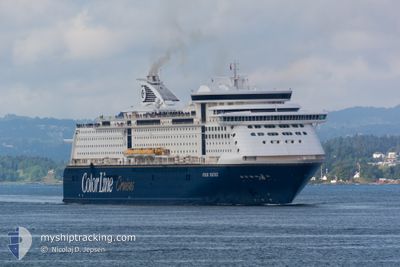
COLOR FANTASY
Ro-Ro/Passenger Ship

Current Trip
| Time Travelled | 13 h, 37 mins |
|---|---|
| Remaining Time | 5 h, 16 mins |
| Distance Travelled | 266.55 nm |
| Remaining Distance | 99.53 nm |
| AVG Speed | 19.7 Knop |
| MAX Speed | 22.5 Knop |
| AVG Wind | 13.2 knots |
| MAX Wind | 30 knots |
| MIN Temp | 12°C / 53.6°F |
| MAX Temp | 17.6°C / 63.68°F |
| Djupgående | 6.9 m |
| Position mottagen | 1 m sen |
Current Position
| Longitud | 10.80015° |
|---|---|
| Latitude | 55.73709° |
| Status | Under way using engine |
| Fart | 19 Knop |
| Kurs | 187.1° |
| Område | Kattegat |
| Station | T-AIS |
| Position mottagen | 1 m sen |
Information
The current position of COLOR FANTASY is in Kattegat with coordinates 55.73709° / 10.80015° as reported on 2025-06-10 01:38 by AIS to our vessel tracker app. The vessel's current speed is 19 Knop and is heading at the port of KIEL. The estimated time of arrival as calculated by MyShipTracking vessel tracking app is 2025-06-10 06:55 LT
The vessel COLOR FANTASY (IMO: 9278234, MMSI: 257182000) is a Ro-Ro/Passenger Ship that was built in 2004 ( 21 År gammal ). It's sailing under the flag of [NO] Norway.
In this page you can find informations about the vessels current position, last detected port calls, and current voyage information. If the vessels is not in coverage by AIS you will find the latest position.
The current position of COLOR FANTASY is detected by our AIS receivers and we are not responsible for the reliability of the data. The last position was recorded while the vessel was in Coverage by the Ais receivers of our vessel tracking app.
The current draught of COLOR FANTASY as reported by AIS is 6.9 meters
Weather
| Temperature | 12.6°C / 54.68°F |
|---|---|
| Wind Speed | 13 knots |
| Direction | 229° SW |
| Pressure | 1015.3 hPa |
| Humidity | 82.9 % |
| Cloud Coverage | 100 % |


Featured Company
Last Port Calls
| Port | Arrival | Departure | Time In Port |
|---|---|---|---|
| 2025-06-09 07:44 | 2025-06-09 12:02 | 4 h | |
| 2025-06-08 07:19 | 2025-06-08 12:16 | 4 h | |
| 2025-06-07 07:42 | 2025-06-07 12:05 | 4 h | |
| 2025-06-06 07:24 | 2025-06-06 12:29 | 5 h | |
| 2025-06-05 07:37 | 2025-06-05 12:24 | 4 h | |
| 2025-06-04 07:22 | 2025-06-04 12:22 | 4 h | |
| 2025-06-03 07:39 | 2025-06-03 12:06 | 4 h | |
| 2025-06-02 07:19 | 2025-06-02 12:25 | 5 h | |
| 2025-06-01 07:49 | 2025-06-01 12:07 | 4 h | |
| 2025-05-31 07:28 | 2025-05-31 12:15 | 4 h |
Last Trips
| Origin | Departure | Destination | Arrival | Distance | |
|---|---|---|---|---|---|
| 2025-06-08 14:16 | 2025-06-09 09:44 | 366.85 nm | |||
| 2025-06-07 14:05 | 2025-06-08 09:19 | 365.22 nm | |||
| 2025-06-06 14:29 | 2025-06-07 09:42 | 366.94 nm | |||
| 2025-06-05 14:24 | 2025-06-06 09:24 | 368.71 nm | |||
| 2025-06-04 14:22 | 2025-06-05 09:37 | 365.92 nm | |||
| 2025-06-03 14:06 | 2025-06-04 09:22 | 367.00 nm | |||
| 2025-06-02 14:25 | 2025-06-03 09:39 | 366.58 nm | |||
| 2025-06-01 14:07 | 2025-06-02 09:19 | 366.10 nm | |||
| 2025-05-31 14:15 | 2025-06-01 09:49 | 366.54 nm | |||
| 2025-05-30 14:04 | 2025-05-31 09:28 | 370.11 nm |
Events
| Tid | Event | Detaljer | Position / Dest | Information |
|---|---|---|---|---|
| 2025-06-10 00:27 | Status ändrad | Under way using engine Default |
56.05266 / 11.09675
DEKEL<>NOOSL
|
Fart: 18.8 kn Kurs: 209° |
| 2025-06-10 00:27 | I täckningsområde |
56.04533 / 11.08954
Kattegat
DEKEL<>NOOSL
|
Fart: 18.9 kn Kurs: 208.9° |
|
| 2025-06-09 21:15 | Status ändrad | Default Under way using engine |
56.96689 / 11.73297
DEKEL<>NOOSL
|
Fart: 19.8 kn Kurs: 161.1° |
| 2025-06-09 21:08 | UTANFÖR täckningsområde |
57.00213 / 11.71014
Kattegat
DEKEL<>NOOSL
|
Fart: 19.8 kn Kurs: 161.1° |
|
| 2025-06-09 20:17 | Byter havsområde | Danish part of the Kattegat Swedish part of the Kattegat |
57.27389 / 11.53568
Kattegat
DEKEL<>NOOSL
|
Fart: 20.6 kn Kurs: 165.2° |
| 2025-06-09 18:31 | Byter havsområde | Swedish part of the Kattegat Swedish part of the Skaggerak |
57.84191 / 11.15134
Kattegat
DEKEL<>NOOSL
|
Fart: 20.1 kn Kurs: 164.5° |
| 2025-06-09 16:44 | Status ändrad | Under way using engine Default |
58.40114 / 10.81549
DEKEL<>NOOSL
|
Fart: 19.9 kn Kurs: 159° |
| 2025-06-09 16:43 | Status ändrad | Default Under way using engine |
58.40823 / 10.81024
DEKEL<>NOOSL
|
Fart: 19.7 kn Kurs: 158.9° |
| 2025-06-09 16:42 | Status ändrad | Under way using engine Default |
58.41181 / 10.80764
DEKEL<>NOOSL
|
Fart: 19.6 kn Kurs: 158° |
| 2025-06-09 16:39 | Status ändrad | Default Under way using engine |
58.42809 / 10.79524
DEKEL<>NOOSL
|
Fart: 19.6 kn Kurs: 158.5° |