
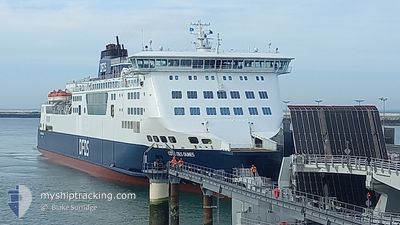
COTE DES DUNES
Ro-Ro/Passenger Ship
Current Trip
| Time Travelled | 4 h, 2 mins |
|---|---|
| Remaining Time | 30 mins |
| Distance Travelled | 40.75 nm |
| Remaining Distance | 13.47 nm |
| AVG Speed | 13.2 Knop |
| MAX Speed | 16 Knop |
| AVG Wind | 9.2 knots |
| MAX Wind | 10 knots |
| MIN Temp | 7.9°C / 46.22°F |
| MAX Temp | 8.6°C / 47.48°F |
| Djupgående | 6 m |
| Position mottagen | 1 m sen |
Current Position
| Longitud | 1.45330° |
|---|---|
| Latitude | 51.11567° |
| Status | Under way using engine |
| Fart | 14.3 Knop |
| Kurs | 294.5° |
| Område | North Sea |
| Station | T-AIS |
| Position mottagen | 1 m sen |
Information
The current position of COTE DES DUNES is in North Sea with coordinates 51.11567° / 1.45330° as reported on 2025-03-31 12:07 by AIS to our vessel tracker app. The vessel's current speed is 14.3 Knop and is heading at the port of CALAIS. The estimated time of arrival as calculated by MyShipTracking vessel tracking app is 2025-03-31 12:39 LT
The vessel COTE DES DUNES (IMO: 9232527, MMSI: 227022800) is a Ro-Ro/Passenger Ship that was built in 2001 ( 24 År gammal ). It's sailing under the flag of [FR] France.
In this page you can find informations about the vessels current position, last detected port calls, and current voyage information. If the vessels is not in coverage by AIS you will find the latest position.
The current position of COTE DES DUNES is detected by our AIS receivers and we are not responsible for the reliability of the data. The last position was recorded while the vessel was in Coverage by the Ais receivers of our vessel tracking app.
The current draught of COTE DES DUNES as reported by AIS is 6 meters
Weather
| Temperature | 8.4°C / 47.12°F |
|---|---|
| Wind Speed | 10 knots |
| Direction | 45° NE |
| Pressure | 1029.1 hPa |
| Humidity | 80.9 % |
| Cloud Coverage | 11 % |
Featured Company
Last Port Calls
| Port | Arrival | Departure | Time In Port |
|---|---|---|---|
| 2025-03-31 07:09 | 2025-03-31 08:07 | 58 m | |
| 2025-03-30 20:18 | 2025-03-31 05:48 | 9 h | |
| 2025-03-30 17:36 | 2025-03-30 18:37 | 1 h | |
| 2025-03-30 12:27 | 2025-03-30 13:20 | 52 m | |
| 2025-03-30 07:17 | 2025-03-30 08:07 | 49 m | |
| 2025-03-29 23:40 | 2025-03-30 00:41 | 1 h | |
| 2025-03-29 18:39 | 2025-03-29 19:35 | 56 m | |
| 2025-03-29 13:26 | 2025-03-29 14:26 | 1 h | |
| 2025-03-29 08:09 | 2025-03-29 09:16 | 1 h | |
| 2025-03-28 18:37 | 2025-03-28 19:42 | 1 h |
Last Trips
| Origin | Departure | Destination | Arrival | Distance | |
|---|---|---|---|---|---|
| 2025-03-31 07:48 | 2025-03-31 08:09 | 21.72 nm | |||
| 2025-03-30 19:37 | 2025-03-30 22:18 | 22.01 nm | |||
| 2025-03-30 14:20 | 2025-03-30 18:36 | 45.84 nm | |||
| 2025-03-30 09:07 | 2025-03-30 13:27 | 46.05 nm | |||
| 2025-03-30 00:41 | 2025-03-30 08:17 | 46.24 nm | |||
| 2025-03-29 19:35 | 2025-03-29 23:40 | 45.54 nm | |||
| 2025-03-29 14:26 | 2025-03-29 18:39 | 45.98 nm | |||
| 2025-03-29 09:16 | 2025-03-29 13:26 | 46.46 nm | |||
| 2025-03-28 19:42 | 2025-03-29 08:09 | 46.82 nm | |||
| 2025-03-28 14:29 | 2025-03-28 18:37 | 45.80 nm |
Events
| Tid | Event | Detaljer | Position / Dest | Information |
|---|---|---|---|---|
| 2025-03-31 11:43 | Byter havsområde | United Kingdom part of the North Sea French part of the North Sea |
51.05618 / 1.58140
North Sea
|
Fart: 15.2 kn Kurs: 316.5° |
| 2025-03-31 10:49 | STARTAR förflyttning | 0.86 nm, North East of CALAIS |
50.97778 / 1.86800
CALAIS<-->DOVER
|
Fart: 6.7 kn Kurs: 297.5° |
| 2025-03-31 09:48 | STOPPAR förflyttning | 0.91 nm, North East of CALAIS |
50.97652 / 1.87112
CALAIS<-->DOVER
|
Fart: 0.2 kn Kurs: 101° |
| 2025-03-31 09:05 | Byter havsområde | French part of the North Sea French part of the English Channel |
50.98643 / 1.63875
North Sea
|
Fart: 14 kn Kurs: 118.6° |
| 2025-03-31 08:46 | Byter havsområde | French part of the English Channel United Kingdom part of the English Channel |
51.02430 / 1.53508
English Channel
|
Fart: 14.6 kn Kurs: 120.4° |
| 2025-03-31 08:07 | AVGÅTT HAMN |
|
51.11962 / 1.34698
CALAIS<-->DOVER
|
Fart: 10 kn Kurs: 111° |
| 2025-03-31 08:06 | Status ändrad | Under way using engine Default |
51.12208 / 1.33915
[GB] DOVER
|
Fart: Kurs: 138° |
| 2025-03-31 08:06 | STARTAR förflyttning |
51.12208 / 1.33915
[GB] DOVER
|
Fart: 9 kn Kurs: 114° |
|
| 2025-03-31 07:26 | Status ändrad | Default Under way using engine |
51.12402 / 1.33542
[GB] DOVER
|
Fart: Kurs: 138° |
| 2025-03-31 07:20 | STOPPAR förflyttning |
51.12402 / 1.33542
[GB] DOVER
|
Fart: Kurs: 138° |