
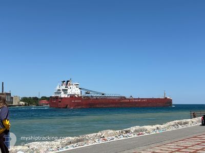
CSL ASSINIBOINE
Self Discharging Bulk Carrier
Current Trip
| Time Travelled | 3 days |
|---|---|
| Remaining Time | --- |
| Distance Travelled | 222.53 nm |
| Remaining Distance | --- |
| AVG Speed | 10.7 Knop |
| MAX Speed | 12.4 Knop |
| AVG Wind | 11.9 knots |
| MAX Wind | 35 knots |
| MIN Temp | -16.4°C / 2.48°F |
| MAX Temp | -1.2°C / 29.84°F |
| Djupgående | 7.4 m |
| Position mottagen | 2 d sen |
Current Position
| Longitud | -75.90195° |
|---|---|
| Latitude | 44.36036° |
| Status | Under way using engine |
| Fart | 10.7 Knop |
| Kurs | 36.3° |
| Område | Gulf of St-Lawrence |
| Station | T-AIS |
| Position mottagen | 2 d sen |
Info
Information
The current position of CSL ASSINIBOINE is in Gulf of St-Lawrence with coordinates 44.36036° / -75.90195° as reported on 2026-01-01 14:49 by AIS to our vessel tracker app. The vessel's current speed is 10.7 Knop and is heading at the port of BECANCOUR. The estimated time of arrival as calculated by MyShipTracking vessel tracking app is 2026-01-03 07:00 LT
The vessel CSL ASSINIBOINE (IMO: 7413218, MMSI: 316001633) is a Self Discharging Bulk Carrier that was built in 1977 ( 49 År gammal ). It's sailing under the flag of [CA] Canada.
In this page you can find informations about the vessels current position, last detected port calls, and current voyage information. If the vessels is not in coverage by AIS you will find the latest position.
The current position of CSL ASSINIBOINE is detected by our AIS receivers and we are not responsible for the reliability of the data. The last position was recorded while the vessel was in Coverage by the Ais receivers of our vessel tracking app.
The current draught of CSL ASSINIBOINE as reported by AIS is 7.4 meters
Weather
| Temperature | -15.5°C / 4.1°F |
|---|---|
| Wind Speed | 1 knots |
| Direction | 222° SW |
| Pressure | 1016.6 hPa |
| Humidity | 93.9 % |
| Cloud Coverage | 100 % |
Featured Company
Last Port Calls
| Port | Arrival | Departure | Time In Port |
|---|---|---|---|
| 2025-12-31 18:04 | 2025-12-31 19:11 | 1 h | |
| 2025-12-27 21:54 | 2025-12-28 00:20 | 2 h | |
| 2025-12-24 23:43 | 2025-12-26 23:47 | 2 d | |
| 2025-12-23 08:47 | 2025-12-23 09:35 | 48 m | |
| 2025-12-22 08:27 | 2025-12-22 10:32 | 2 h | |
| 2025-12-20 10:05 | 2025-12-20 11:23 | 1 h | |
| 2025-12-17 06:23 | 2025-12-17 23:59 | 17 h | |
| 2025-12-15 14:23 | 2025-12-15 14:39 | 16 m | |
| 2025-12-15 04:58 | 2025-12-15 08:02 | 3 h | |
| 2025-12-12 00:48 | 2025-12-13 09:24 | 1 d |
Most Visited Ports (Last year)
| Port | Arrivals | |
|---|---|---|
| 33 | ||
| 32 | ||
| 30 | ||
| 18 | ||
| 13 | ||
| 7 |
Last Trips
| Origin | Departure | Destination | Arrival | Distance | |
|---|---|---|---|---|---|
| 2025-12-28 00:20 | 2025-12-31 18:04 | 533.83 nm | |||
| 2025-12-26 23:47 | 2025-12-27 21:54 | 235.67 nm | |||
| 2025-12-23 09:35 | 2025-12-24 23:43 | 251.94 nm | |||
| 2025-12-22 10:32 | 2025-12-23 08:47 | 236.95 nm | |||
| 2025-12-20 11:23 | 2025-12-22 08:27 | 291.56 nm | |||
| 2025-12-17 23:59 | 2025-12-20 10:05 | 158.93 nm | |||
| 2025-12-15 14:39 | 2025-12-17 06:23 | 310.15 nm | |||
| 2025-12-15 08:02 | 2025-12-15 14:23 | 6.74 nm | |||
| 2025-12-13 09:24 | 2025-12-15 04:58 | 135.44 nm | |||
| 2025-12-12 00:02 | 2025-12-12 00:48 | 3.09 nm |
Events
| Tid | Event | Detaljer | Position / Dest | Information |
|---|---|---|---|---|
| 2026-01-04 01:52 | STOPPAR förflyttning | 14.34 nm, West of CORNWALL |
44.94333 / -75.03167
BECANCOUR
|
Fart: Kurs: -1° |
| 2026-01-03 22:16 | STARTAR förflyttning | 1.76 nm, South West of PRESCOTT |
44.68333 / -75.53833
BECANCOUR
|
Fart: 8 kn Kurs: 44° |
| 2026-01-01 17:44 | STOPPAR förflyttning | 2.09 nm, South West of PRESCOTT |
44.67717 / -75.53929
BECANCOUR
|
Fart: 0.1 kn Kurs: 225° |
| 2026-01-01 14:55 | Status ändrad | Default Under way using engine |
44.37333 / -75.88834
BECANCOUR
|
Fart: 10.7 kn Kurs: 36.3° |
| 2026-01-01 14:49 | UTANFÖR täckningsområde |
44.36036 / -75.90195
Gulf of St-Lawrence
BECANCOUR
|
Fart: 10.7 kn Kurs: 36.3° |
|
| 2026-01-01 12:21 | Status ändrad | Under way using engine Default |
44.10978 / -76.38900
BECANCOUR
|
Fart: 11 kn Kurs: 39° |
| 2026-01-01 12:21 | I täckningsområde |
44.11296 / -76.38425
Gulf of St-Lawrence
BECANCOUR
|
Fart: 11.1 kn Kurs: 50.5° |
|
| 2026-01-01 02:06 | Status ändrad | Default Under way using engine |
43.39668 / -78.78768
BECANCOUR
|
Fart: 12 kn Kurs: 72.7° |
| 2026-01-01 01:59 | UTANFÖR täckningsområde |
43.39115 / -78.81503
Gulf of St-Lawrence
BECANCOUR
|
Fart: 12 kn Kurs: 72.7° |
|
| 2026-01-01 01:35 | Status ändrad | Under way using engine Default |
43.36831 / -78.92401
BECANCOUR
|
Fart: 12.2 kn Kurs: 73° |