
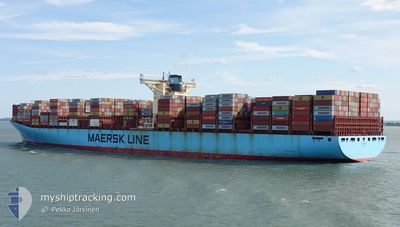
ELLY MAERSK
Container Ship
Current Trip
| Time Travelled | 4 days |
|---|---|
| Remaining Time | --- |
| Distance Travelled | 1960.88 nm |
| Remaining Distance | --- |
| AVG Speed | 19.6 Knop |
| MAX Speed | 21.1 Knop |
| AVG Wind | 13.7 knots |
| MAX Wind | 28.3 knots |
| MIN Temp | 14.1°C / 57.38°F |
| MAX Temp | 26.9°C / 80.42°F |
| Djupgående | 15.2 m |
| Position mottagen | 2 d sen |
Current Position
| Longitud | -14.98607° |
|---|---|
| Latitude | 26.58713° |
| Status | Under way using engine |
| Fart | 20.1 Knop |
| Kurs | 216.8° |
| Område | North Atlantic Ocean |
| Station | T-AIS |
| Position mottagen | 2 d sen |
Info
Information
The current position of ELLY MAERSK is in North Atlantic Ocean with coordinates 26.58713° / -14.98607° as reported on 2025-02-07 06:11 by AIS to our vessel tracker app. The vessel's current speed is 20.1 Knop and is heading at the port of ABU DHABI. The estimated time of arrival as calculated by MyShipTracking vessel tracking app is 2025-02-27 17:00 LT
The vessel ELLY MAERSK (IMO: 9321536, MMSI: 220499000) is a Container Ship that was built in 2007 ( 18 År gammal ). It's sailing under the flag of [DK] Denmark.
In this page you can find informations about the vessels current position, last detected port calls, and current voyage information. If the vessels is not in coverage by AIS you will find the latest position.
The current position of ELLY MAERSK is detected by our AIS receivers and we are not responsible for the reliability of the data. The last position was recorded while the vessel was in Coverage by the Ais receivers of our vessel tracking app.
The current draught of ELLY MAERSK as reported by AIS is 15.2 meters
Weather
| Temperature | 26.9°C / 80.42°F |
|---|---|
| Wind Speed | 3 knots |
| Direction | 288° WNW |
| Pressure | 1008.4 hPa |
| Humidity | 70.4 % |
| Cloud Coverage | 28 % |
Featured Company
Last Port Calls
| Port | Arrival | Departure | Time In Port |
|---|---|---|---|
| 2025-02-05 02:19 | 2025-02-05 17:26 | 15 h | |
| 2025-01-31 00:15 | 2025-02-01 12:32 | 1 d | |
| 2025-01-25 15:37 | 2025-01-30 01:09 | 4 d | |
| 2025-01-20 07:36 | 2025-01-23 14:24 | 3 d | |
| 2025-01-17 05:02 | 2025-01-18 21:32 | 1 d | |
| 2024-12-22 00:59 | 2024-12-23 00:55 | 23 h | |
| 2024-12-14 06:15 | 2024-12-15 04:09 | 21 h | |
| 2024-12-09 03:08 | 2024-12-10 11:44 | 1 d | |
| 2024-12-06 04:36 | 2024-12-06 23:50 | 19 h | |
| 2024-12-04 09:20 | 2024-12-05 15:21 | 1 d |
Most Visited Ports (Last year)
| Port | Arrivals | |
|---|---|---|
| 4 | ||
| 4 | ||
| 4 | ||
| 4 | ||
| 4 | ||
| 3 |
Last Trips
| Origin | Departure | Destination | Arrival | Distance | |
|---|---|---|---|---|---|
| 2025-02-01 12:32 | 2025-02-05 02:19 | 1405.75 nm | |||
| 2025-01-30 01:09 | 2025-01-31 00:15 | 189.19 nm | |||
| 2025-01-23 14:24 | 2025-01-25 15:37 | 451.14 nm | |||
| 2025-01-18 21:32 | 2025-01-20 07:36 | 403.20 nm | |||
| 2024-12-23 00:55 | 2025-01-17 05:02 | 10843.08 nm | |||
| 2024-12-15 04:09 | 2024-12-22 00:59 | 1638.07 nm | |||
| 2024-12-10 11:44 | 2024-12-14 06:15 | 1482.63 nm | |||
| 2024-12-06 23:50 | 2024-12-09 03:08 | 170.35 nm | |||
| 2024-12-05 15:21 | 2024-12-06 04:36 | 136.73 nm | |||
| 2024-11-21 11:19 | 2024-12-04 09:20 | 5012.27 nm |
Events
| Tid | Event | Detaljer | Position / Dest | Information |
|---|---|---|---|---|
| 2025-02-07 06:14 | Status ändrad | Default Under way using engine |
26.57078 / -14.99953
MAPTM-AEAUH
|
Fart: 20.1 kn Kurs: 216.8° |
| 2025-02-07 06:11 | UTANFÖR täckningsområde |
26.58713 / -14.98607
North Atlantic Ocean
MAPTM-AEAUH
|
Fart: 20.1 kn Kurs: 216.8° |
|
| 2025-02-07 05:48 | Status ändrad | Under way using engine Default |
26.68868 / -14.90274
MAPTM-AEAUH
|
Fart: 20.1 kn Kurs: 217° |
| 2025-02-07 05:47 | Status ändrad | Default Under way using engine |
26.69319 / -14.89898
MAPTM-AEAUH
|
Fart: 20.1 kn Kurs: 216.9° |
| 2025-02-07 05:37 | Status ändrad | Under way using engine Default |
26.73907 / -14.85990
MAPTM-AEAUH
|
Fart: 20.1 kn Kurs: 216° |
| 2025-02-07 05:31 | Status ändrad | Default Under way using engine |
26.76439 / -14.83893
MAPTM-AEAUH
|
Fart: 20.2 kn Kurs: 216.9° |
| 2025-02-07 03:53 | Byter havsområde | Western Saharan part of the North Atlantic Ocean Spanish (Canary Islands) part of the North Atlantic Ocean |
27.20894 / -14.47086
North Atlantic Ocean
MAPTM-AEAUH
|
Fart: 20.5 kn Kurs: 219.6° |
| 2025-02-07 03:15 | Status ändrad | Under way using engine Default |
27.38239 / -14.32392
MAPTM-AEAUH
|
Fart: 20.5 kn Kurs: 217° |
| 2025-02-07 03:07 | Status ändrad | Default Under way using engine |
27.41682 / -14.29494
MAPTM-AEAUH
|
Fart: 20.6 kn Kurs: 216.7° |
| 2025-02-07 00:13 | Status ändrad | Under way using engine Default |
28.22106 / -13.62152
MAPTM-AEAUH
|
Fart: 20.6 kn Kurs: 218° |