

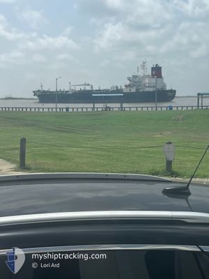
EVERGREEN STATE
Oil/Chemical Tanker

Current Trip
MILITARY OPS
| Time Travelled | 4 days |
|---|---|
| Remaining Time | --- |
| Distance Travelled | 789.47 nm |
| Remaining Distance | --- |
| AVG Speed | 10.1 Knop |
| MAX Speed | 14.5 Knop |
| AVG Wind | 9.8 knots |
| MAX Wind | 17 knots |
| MIN Temp | 16.7°C / 62.06°F |
| MAX Temp | 25.1°C / 77.18°F |
| Djupgående | 9.9 m |
| Position mottagen | 2 d sen |
Current Position
| Longitud | -81.25682° |
|---|---|
| Latitude | 30.39381° |
| Status | Under way using engine |
| Fart | 9.7 Knop |
| Kurs | 107° |
| Område | North Atlantic Ocean |
| Station | T-AIS |
| Position mottagen | 2 d sen |
Information
The current position of EVERGREEN STATE is in North Atlantic Ocean with coordinates 30.39381° / -81.25682° as reported on 2025-03-30 20:43 by AIS to our vessel tracker app. The vessel's current speed is 9.7 Knop
The vessel EVERGREEN STATE (IMO: 9408138, MMSI: 367353070) is a Oil/Chemical Tanker that was built in 2010 ( 15 År gammal ). It's sailing under the flag of [US] USA.
In this page you can find informations about the vessels current position, last detected port calls, and current voyage information. If the vessels is not in coverage by AIS you will find the latest position.
The current position of EVERGREEN STATE is detected by our AIS receivers and we are not responsible for the reliability of the data. The last position was recorded while the vessel was in Coverage by the Ais receivers of our vessel tracking app.
The current draught of EVERGREEN STATE as reported by AIS is 9.9 meters
Weather
| Temperature | 25.1°C / 77.18°F |
|---|---|
| Wind Speed | 13 knots |
| Direction | 93° E |
| Pressure | 1019.2 hPa |
| Humidity | 84.3 % |
| Cloud Coverage | 100 % |


Featured Company
Last Port Calls
| Port | Arrival | Departure | Time In Port |
|---|---|---|---|
| 2025-03-27 07:38 | 2025-03-28 11:55 | 1 d | |
| 2025-03-20 23:54 | 2025-03-22 15:56 | 1 d | |
| 2025-03-14 23:03 | 2025-03-15 23:37 | 1 d | |
| 2025-03-06 07:28 | 2025-03-07 15:23 | 1 d | |
| 2025-02-28 00:11 | 2025-02-28 18:23 | 18 h | |
| 2025-02-14 03:14 | 2025-02-23 16:34 | 9 d | |
| 2025-02-10 16:25 | 2025-02-12 22:28 | 2 d | |
| 2025-02-02 11:22 | 2025-02-04 17:34 | 2 d |
Most Visited Ports (Last year)
| Port | Arrivals | |
|---|---|---|
| 14 | ||
| 9 | ||
| 6 | ||
| 4 | ||
| 4 | ||
| 4 |
Last Trips
| Origin | Departure | Destination | Arrival | Distance | |
|---|---|---|---|---|---|
| 2025-03-22 15:56 | 2025-03-27 07:38 | 1364.65 nm | |||
| 2025-03-15 23:37 | 2025-03-20 23:54 | 700.40 nm | |||
| 2025-03-07 15:23 | 2025-03-14 23:03 | 1067.31 nm | |||
| 2025-02-28 18:23 | 2025-03-06 07:28 | 1230.00 nm | |||
| 2025-02-23 16:34 | 2025-02-28 00:11 | 1394.75 nm | |||
| 2025-02-12 22:28 | 2025-02-14 03:14 | 215.48 nm | |||
| 2025-02-04 17:34 | 2025-02-10 16:25 | 372.23 nm | |||
| 2025-01-27 19:06 | 2025-02-02 11:22 | 156.52 nm |
Events
| Tid | Event | Detaljer | Position / Dest | Information |
|---|---|---|---|---|
| 2025-03-30 20:48 | Status ändrad | Default Under way using engine |
30.38972 / -81.24188
MILITARY OPS
|
Fart: 9.7 kn Kurs: 107° |
| 2025-03-30 20:43 | UTANFÖR täckningsområde |
30.39381 / -81.25682
North Atlantic Ocean
|
Fart: 9.7 kn Kurs: 107° |
|
| 2025-03-30 20:21 | Status ändrad | Under way using engine Default |
30.41130 / -81.31920
MILITARY OPS
|
Fart: 7.5 kn Kurs: 74° |
| 2025-03-30 20:20 | Status ändrad | Default Under way using engine |
30.41133 / -81.32080
MILITARY OPS
|
Fart: 8.2 kn Kurs: 52° |
| 2025-03-30 18:41 | Status ändrad | Under way using engine Default |
30.40648 / -81.60393
MILITARY OPS
|
Fart: 6.4 kn Kurs: 57° |
| 2025-03-30 18:40 | Status ändrad | Default Under way using engine |
30.40585 / -81.60505
MILITARY OPS
|
Fart: 6.5 kn Kurs: 58° |
| 2025-03-30 18:32 | STARTAR förflyttning | 3.86 nm, North of JACKSONVILLE |
30.39905 / -81.61880
MILITARY OPS
|
Fart: 3.7 kn Kurs: 62° |
| 2025-03-30 18:14 | Status ändrad | Under way using engine Default |
30.39938 / -81.62145
MILITARY OPS
|
Fart: Kurs: 240° |
| 2025-03-30 18:12 | Status ändrad | Default Under way using engine |
30.39937 / -81.62144
MILITARY OPS
|
Fart: Kurs: 240° |
| 2025-03-30 17:57 | Status ändrad | Under way using engine Default |
30.39938 / -81.62143
MILITARY OPS
|
Fart: 0.1 kn Kurs: 240° |